ALPINE NATIONAL PARK
(www.northeastvictoria.online)
The Alpine National Park was created in December 1989, combining what was then Bogong National Park and Wonnangatta - Moroka National Park.
This is the largest national park in Victoria, covering about 6460 square kilometres of high country, stretching along the Great Dividing Range through to the New South Wales High Country. Here it links up with Kosciuszko National Park, and then Namadgi National Park.
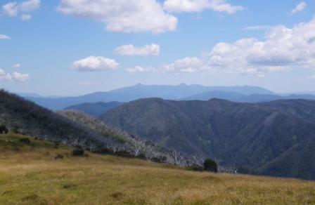
Much of the Alpine National Park is above the snowline, with blue tinged peaks, high plains areas and deep river valleys.
The ubiquitous snowgum is found at most localities in the park and where conditions are too severe for trees to survive, there are extensive heathlands, grasslands and bogs.
The high plains areas are also renowned for their summer wildflower displays, usually at their best in January.
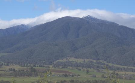
Mount Bogong, at 1986m, is one of the highlights of the Alpine National Park, and has the distinction of being the highest point in Victoria; it attracts a lot of attention from keen walkers and peak baggers.
The best times of year for visiting the Park are late spring, summer and early autumn (winter weather includes blizzards and thick fog, making walking conditions extremely unfavourable).
In any case bad weather can occur at all times of the year, so take some warm clothing, a wind-proof outer garment and some ‘emergency’ supplies.
The Parks Victoria website (see below) has some handy PDF files, with maps, and further information on the Park.
Mount Bogong [AWTGS-4]
As previously mentioned, Mount Bogong is Victoria’s highest peak (1986m) and deserves respect; the walk described here involves steep terrain, and a fair amount of time in an alpine environment that has claimed several lives in the not-too-distant past.
Walkers on this route should be well equipped, and reasonably experienced in alpine walking conditions. Navigation wise, you will need a waterproof GPS (such as a Magellan Triton) and a copy of Spatial Vision’s map Bogong Alpine Area.
If this is to be a day trip for you, then you should allow a very full day, with an early start to allow for any unforseen delays, and/or the opportunity to linger in the summit area.
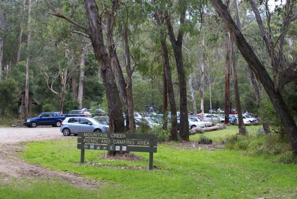
The walk starts at the gateway to the Alpine National Park, at Mountain Creek Picnic/Camping Area. Access is from Mountain Creek Lane, which leads off the Kiewa Valley Highway, adjacent to the former Bogong View Hotel in Tawonga South.
Mountain Creek Lane is sealed for much of the distance to the start of the walk, but the last few kilometres are gravel. As this road is extensively used by walkers and cyclists, it is best to keep your vehicle speed down. Except in peak periods, there is ample parking space for cars at the Mountain Creek Picnic/Camping Area.
The walk to the summit begins from the track at Mountain Creek car park, and don’t forget to fill in the intentions book before setting off!
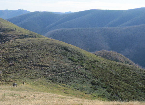
The track crosses Mountain Creek several times, and passes the base of the Staircase Spur track (after about two kilometres) which forms part of the return route, but which can also be used as an up-down route in its own right. Camp Creek Gap is the next landmark, where a turn to the south (right) is required to pick up the Eskdale Spur Track.
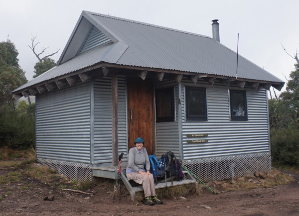
A change in vegetation confirms the messages from your thighs that you are now on the way up in life. Continue up the slope, cross a stream (actually slightly off the track) and up to Michell Hut.
Once at the Hut you are at about 1600m, and the climb continues relentlessly, following a snow pole route up the tree line (about 1700m) near the top of a spur.
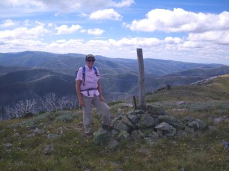
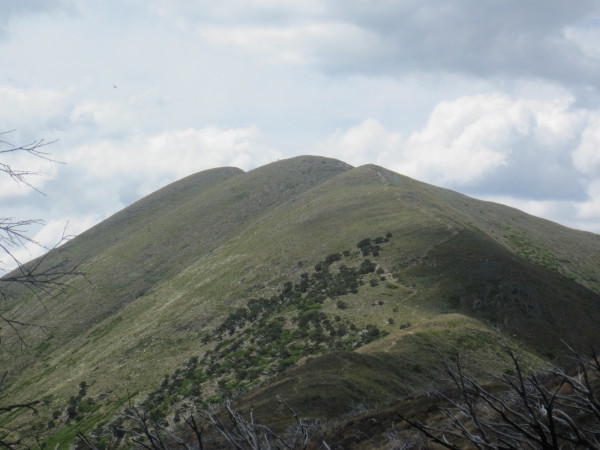
Turning right here leads through alpine meadows, following the ridge track for about 500m (past the top of Staircase Spur - return route) to the rock cairn that marks the highest point in Victoria. There is no single best vantage point here so it is a good idea to wander around the summit area and get a few good viewpoints. On a clear day there are many excellent views of the surrounding high country, and the river valleys below.
When the pylons for the Dartmouth hydro-electric power station were being installed (in the early 1980s) there was concern about the visual impact of power pylons in pristine bushland (particularly from the top of Mount Bogong), as well as the initial impact of huge swathes of land being cleared to facilitate vehicular access for cable laying.
The visual impact of the power pylons was minimised by their careful placement, and by painting them green. Getting the cables installed was far more ingenious. Instead of clearing land between all of the pylons to lay the cables (normal practice), model aircraft were employed in many locations to fly very fine fibres between some pylons; these were then used to drag progressively larger fibres across the void, followed by ropes and then stronger ropes. Eventually, the ropes were used to pull the power cables into position.
If you are on a day trip, walk back towards Eskdale Spur, and veer left down the Staircase Spur. This leads past the site of the derelict Summit Hut, and a memorial cairn to a party of skiers (Georgine Gadsden, John McCrae and Edward Welch) who died near here in August 1943. The trio were trying to reach Cleve Cole Hut (see below) in blizzard conditions, and were found several days later; the memorial obelisk was erected in 1945.
Soon after the memorial, the tree line is reached, and then the Bivouac Hut ruins, and its nearby replacement.
The descent continues, steep in places, finally reaching familiar territory at Mountain Creek. Turn left here, and walk the final two kilometres back to the Mountain Creek picnic area.
Cleve Cole Hut [AWTGS-5]
If you have more time (that is, you are camping on the mountain) you may want to follow the snow poles down the ridge, past Hells Gap, and then south-east to the Cleve Cole Memorial Hut (about four kilometres in total) - taking care to return via the same route - see the recommended map for more details.
The Cleve Cole Hut commemorates the work of a pioneer skier of the high country who died in August 1936. Cleve Cole, and other members of his party, were caught out in bad weather on the southern slopes of Mount Bogong, and eventually had to be rescued by another party, after having endured several days of appalling alpine conditions.
Cleve was taken to the Omeo Hospital but died there, having been treated for all of the effects of frostbite and hypothermia.
The Memorial Hut was erected by volunteer labour during the summer of 1937-1938, and is still maintained by local volunteers. The Hut was given a Victorian Heritage Listing in 1988, and is recognised as being one of the most substantial of the high country huts (it is constructed of local stone).
See Harry Stephenson’s masterpiece Ski-ing the High Plains for more details of both of the tragedies mentioned. Janis Lloyd’s Ski-ing into History also covers these events. Both books have been out of print for a long time, but many libraries still have a treasured copy of both titles.
Cleve Cole Hut is a good place to make camp for the night (a reasonable amount of shelter) and if this is your chosen site it is worthwhile taking the short trip to Howmans Falls about 1.5km away. The Falls can be reached by following the Alpine Walking Track east for about a kilometre, and then turning right (south) at Camp Creek. Return home via the reverse route and the Staircase Spur.
Mount Feathertop [AWTGS-4]
Mount Feathertop, at 1922m, is the second highest peak in Victoria and the second highest in the Alpine National Park. The feathery wind-driven plumes of powder-snow that often drift from its abrupt peak gave the mountain its name, and although sounding quite nice and innocent this mountain, like any other, deserves respect.
Access is via the Mount Hotham Road (the Great Alpine Road) out of Bright, and the walk described here is a 38km loop (13km on day one, leaving 25km for day two) with a tough ascent/descent. However the walk can be trimmed back to about 20km (see Razorback Ridge route description below). In either case this is a long walk in alpine/sub-alpine conditions and it is best to start early in the morning.
Snow is not unknown in any month of the year, however November to April usually offer "safe" conditions (that is, little likelihood of snow) but even so, be prepared for a change in the weather. Old-timers of the high country still talk about the big falls of December 1939, which gave perfect skiing on Christmas Day of that year.
The start of the walk is reached by taking the Mount Hotham Road from Bright, turning left just before the Ovens River Bridge in Harrietville. Drive for about one kilometre (across old gold diggings) to the car park at the start of Bungalow Spur Track. Recommended maps include Spatial Vision Bogong Alpine Area and the VicMap 1:50 000 sheet Falls Creek.
After signing the walk register, take the Bungalow Spur track up to Wombat Gap and then snowgum country where the ruins of Bungalow Hut and (the old) Feathertop Hut are encountered (this is about eight kilometres from the start). Another kilometre and the tree line and the present day Federation Hut (built in 1968) are reached. The environs of the hut are a good place to make camp for the night and a good base for exploring and peak bagging.
The final climb to the summit (still two kilometres away) continues along the track for 500m to a memorial cross (origin unknown) where Razorback Ridge Track joins from the right. With the peak of Mount Feathertop now in view, follow the track north-east to the summit (the track off to the left leads to the igloo-shaped Melbourne University Mountaineering Club Hut). Once at the summit there are (as expected) great views of the Victorian High Country and of course the Ovens River Valley far below.
The descent (on the following day) can either be by retracing your steps downhill (hard on the thigh muscles) or by heading south along Razorback Ridge, a narrow spine which links Mount Feathertop to Mount Hotham 10km away. If you choose the latter option, you will need some road transport to get back to your vehicle at Harrietville. See the next section for more details of this route.
Razorback Ridge [AWTGS-4]
Razorback Ridge offers the easiest access to Feathertop, being shorter (about 26km, all up) and involving less vertical height gain (only about 200m) and for this reason is a more popular route than the direct approach from Harrietville.
To get to the summit via The Razorback, drive to Diamantina Hut on the Great Alpine Road (see the Main Menu), park the hardware, and then walk northwards to the Bon Accord Spur. This in turn leads down to the Big Dipper, a saddle where there are impressive areas of snowgum woodlands, and some great walking country.
The track now climbs over the Twin Knobs, and skirts High Knob, eventually coming across the Molly Hill Memorial Cairn just before the Bungalow Spur Track (Molly Hill was a skier who lost her life here in 1932).
See the description of the Great Alpine Road for more details of this popular (albeit hard) walk.
Falls Creek - Mount Hotham Alpine Crossing [AWTGS-4]
The Falls Creek to Hotham Alpine Crossing, also known as Falls - Hotham Alpine Crossing (FHAC), is a 38.5km, one way hike, and takes about three days to complete.
There are two campsites; Cope Hut campsite, set amongst snowgums on the Bogong High Plains, 14km from the trailhead and usually the first night’s campsite; Dibbins Hut campsite, on a snow plain in the headwaters of the Cobungra River, about 30km from Falls Creek (that is, about nine kilometres from the Mount Loch car park, a few kilometres north of Mount Hotham).
Each campsite has five sites, four of which have a formal tent platform that is designed to fit a 2-3 person hiking tent, and a larger platform for small groups/larger tent.
At Falls Creek the trail starts from the Heathy Spur carpark, on the eastern side of the Rocky Valley Dam Wall. This is about three kilometres from the Falls Creek Information Centre by road, or you can walk from the village bowl, mostly via formal off-road tracks.
At Mount Hotham, the trail finishes at the Mt Loch carpark, just off the Great Alpine Road, a few kilometres north of Mount Hotham.
Some data : Total distance: 38.5km; highest point 1832m; lowest point 1351m; total ascent 1400m; total descent 1190m.
There are several websites that cover the walk in more detail than than given here, and most of these offer a downloadable GPX file with all of the crucial GPS waypoints.
See below for the official website to this walk.
See also the Touring Routes descriptions on the HomePage; many of these include walk descriptions within the National Park, for example
Great Alpine Road
King Valley
Lake Cobbler
Mount Beauty - Omeo
Omeo - Mitta Mitta
As well, there are many great other walking tracks within the National Park, and for definitive descriptions of many of these walks, see Bushwalks in the Victorian Alps by Glen van der Knijff (details at www.osp.com.au). Click here for this website
The page, More Bushwalks on the Bogong High Plains - accessible via the above mentioned Mount Beauty - Omeo Tour, also has detailed walks descriptions.
The Australian Alpine Walking Track (AAWT) covers 765km of spectacular High Country terrain and extends from Walhalla (in Victoria) to Canberra, making a complete traverse of the National Park, with many opportunities for peak bagging along the way. The AAWT (which has an overall grading of AWTGS-4) dates from the late 1960s, and is one of the best long distance trails in Australia.
However, If you have the time, it is worthwhile stepping out for an hour along a short section of the Track at one of the intermediate points. Features of the AAWT can be found in the publication Australian Alpine Walking Track by John Siseman; see www.john.chapman.name for more details. Click here for this website
Intro Screen on a fresh browser page
COPYRIGHT © 1995-2025, Chris McLaughlin.