BIKE PATHS, RAIL TRAILS and CYCLE ROUTES
(www.northeastvictoria.online)
WANGARATTA TO ELDORADO
This ride makes use of the early section of The Murray to the Mountains Rail Trail that runs from Wangaratta to Bright, and some of the description of that Rail Trail is repeated here for convenience.
Given that much of this ride is on a gravel surface, this ride is not recommended for road bikes; mountain bikes are best, with hybrids being a good second choice, given that they have good quality tyres (and tubes) fitted.
The Rail Trail section surface is mostly gravel, set in bitumen, and provides a good ride in most places. There are many bridges to traverse, and the surface of these varies from steel, to timber to concrete to gravel; slow down for the timber ones, as their surface is not the best.
The Trail also crosses the Great Alpine Road (GAR), and this requires great care, as traffic on the GAR may be travelling quite fast.
Weather watching should form a part of your trip planning, with hot weather and wet weather being times to avoid. Dehydration will be a major problem on days of 30+, and wet weather creates miserable cycling conditions. The cooler months of the year often provide ideal cycling conditions, with a nice sunny day in autumn or winter being hard to beat.
If there is a flood warning (of any kind) for the Ovens River at Wangaratta, then some of the early sections of the Trail will have water over them. Sections most affected by floodwaters are Apex Park (the start of the Trail), the section from Apex Park to the Vine Hotel, and the Hume Freeway underpass.
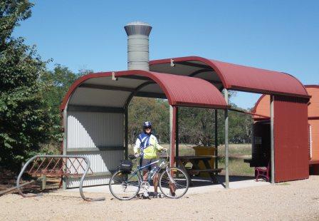
Mobile coverage along the Trail is almost 100%, with Telstra currently providing the best outcome. As well, there are several emergency phones en route, and these can be used if you have a major problem.
Many riders take a small repair kit with them, including a spare inner tube, and the necessary tools to fix simple problems. As well, don’t forget to take some nibbles in case you get peckish, and about one litre of water per person.
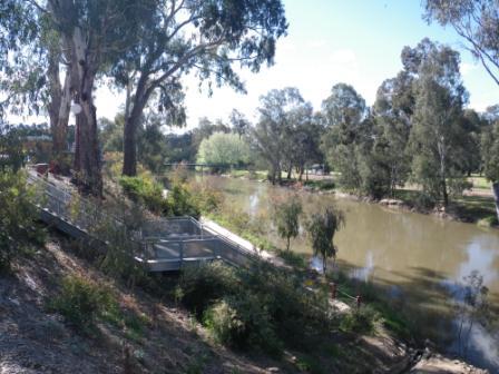
The Rail Trail officially starts at Apex Park, just over the Ovens River Bridge, which itself is just north of the CBD. There is plenty of room for parking, and unloading here, as well as picnic amenities and a toilet block.
Getting to Apex Park from the CBD either involves mixing with traffic in Murphy Street, and then taking the main Ovens River Bridge (which is quite narrow); or taking the slightly quieter Ovens Street, and then taking the Bickerton Street suspension bridge over the Ovens (the suspension bridge carries pedestrian and bike traffic only).
Starting off from around Merriwa Park is slightly easier, as you can just follow the flood levee through to Chisholm Street, then swing into Faithfull Street, cross over the Mitchell Bridge (over the Ovens River) and then pick up the Rail Trail on the north side of the Bridge.
If you are starting your journey from Wangaratta’s railway station, then the Rail Trail is quite clearly signposted, and these will guide you from the Station to the suspension bridge. Just opposite the station, Cafe Derailleur can provide some nice refreshments to kick off your adventure.
Once at Apex Park, the Trail leads off through an underpass of the Ovens River Bridge, and then swings left at the Ovens River / King River confluence, before getting up to speed along one of Wangaratta’s many flood levees.
The Trail then crosses the Great Alpine Road (GAR, take care) and heads north, basically following the old Hume Highway, and then the original Hume Highway, before emerging at the Vine Hotel. This is one of Wangaratta's oldest pubs, and was a haunt of the Kelly Gang in the bushranger era. In the modern era it serves a great meal.
From the Vine, the official Trail veers left, and continues to follow the old Hume Highway northwards to Bowser Station (about seven kilometres north of town, 152m altitude). This was a major signalling station in the old days, but was dismantled when the Bright and Beechworth Railways were discontinued. From Bowser the Rail Trail finally swings to the east, and you then need to negotiate a short (but dark) tunnel under the Hume Freeway. Once out in the daylight, you are on track for Eldorado.
[An alternative route (that avoids the Freeway tunnel, and is slightly shorter than the official route) involves using some short sections of rural roads (take care!). This short detour involves swinging right at the Vine Hotel, and then left onto the Eldorado Road. After crossing over (not under) the Freeway, you can then swing left to pick up the Byawatha Road; this then intersects the Rail Trail a few kilometres east of that dark tunnel.]
Just beyond the intersection of the Rail Trail and Byawatha Road, there is a small road going off to the right (Bowser - Londrigan Lane) which should be ignored, and a further 500m (or so) leads to a right turn onto another minor road - Clear Creek Road. Note that the Bowser - Londrigan Lane is not shown on all maps.
Swing right at Clear Creek Road, and settle back for a 10km bumpy ride to the environs of Eldorado.
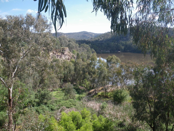
Clear Creek Road is mostly unsealed, but is an all-weather pathway, having quite a heavy metalled surface, which does not provide the most comfortable of rides. However, there is plenty of interest on the ride, with the roadway having been built on a geological feature known as a ’swing terrace’ (a system of long-since abandoned waterway banks; abandoned since the waterway has since eroded its way down into the alluvial soils to a much lower level).
Being on the swing terraces gives you a height advantage, and there are many excellent views of the Creek’s floodplain down below, as well as good views of the swing terrace on the opposite side of the Creek’s floodplain.
The route (which is mostly tree-lined) intersects some bitumen at an off-set cross-roads, and you need to basically keep straight-ahead at this point. This then leads to a y-junction where you need to keep right (taking Powerhouse Lane) and keep on pedalling until you come to a t-junction.
Veer right here, and follow the roadway down to a low level crossing of Reedy Creek, with the road access to Cocks Dredge being on your left, just after the Creek (the Dredge is described in the Wangaratta - Beechworth (via Eldorado) description).
Having pedalled past the Dredge access road, the bitumen of the Wangaratta - Eldorado Road is quickly encountered, and here you need to make a sharp left, remembering to be aware that this can be quite a busy stretch of road.
The township of Eldorado is now about 1.5km away, with details of this interesting township being available in the Wangaratta - Beechworth (via Eldorado) description).
If you want to rejoin the Murray to Mountains Rail Trail, you can either retrace your steps to the Byawatha Road, or take the bitumen of the Eldorado - Tarrawingee Road. This latter option leads towards the main Tarrawingee - Beechworth Road, with the Murray to Mountains Rail Trail being intersected about 1200m prior to the bitumen.
[An alternative route from the Murray to Mountains Rail Trail to Eldorado involves turning off the Trail at Londrigan, and taking the main Wangaratta - Eldorado Road through to Eldorado. This is a quicker route than the one described above, however this is quite a busy road, and is nowhere near as scenic as our preferred route.]
Intro Screen on a fresh browser page
COPYRIGHT © 1995-2020, Chris McLaughlin.