BURROWA - PINE MOUNTAIN NATIONAL PARK
(www.northeastvictoria.online)
This fascinating National Park is based on two mountainous blocks of land, linked by a narrow corridor, and covers an area of about 18 000 hectares. The southern part of the Park is dominated by Mount Burrowa (1300m), whilst the highest point of the northern block is Pine Mountain (1062m) from which spectacular views of the Murray Valley, and the high country, can be obtained.
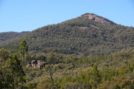
Pine Mountain has the distinction of being the largest monolith in Australia, bigger than Uluru apparently. Unlike Uluru, Pine Mountain is covered in vegetation so the size of this monolith is not as obvious as the big red one.
Attractions of the National Park include walking tracks to Bluff Falls, Campbells Lookout, Ross Lookout and Pine Mountain, all of which are described here.
The first two walks have reasonably well defined (and popular) walking tracks; the last two require some bushwalking experience, as the tracks are not well defined, the terrain is much trickier, and the time taken is much longer.
The Rooftop Map Upper Murray Adventure Map shows the general locality of the four walks, and the VicMap 1:50 000 sheet is Corryong (available in print, and digital format). The Parks Victoria website (see below) also has some handy PDF downloads, with maps and further information on the Park.
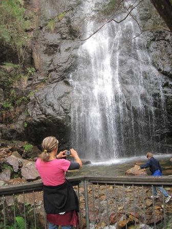
Bluff Falls [AWTGS-2]
Bluff Falls are a scenic cascade that plunge off the side of Bluff Mountain; some maps refer to them as Cudgewa Bluff Falls, but by any name they are well worth seeing. Initial (vehicular) access is from the south (the Corryong area) or Walwa to the north.
Noted waterfall painter, Dacre Smyth nick-named the Falls Titans Stairway because of the stepped nature of the overall cascade.
From Corryong, take Parish Lane from the western side of town (signposted to the National Park). Not far out of town, Parish Lane becomes the Briggs Gap Road, and provides a scenic start to the day, with the bitumen leading over the range from Corryong to the Cudgewa Creek Valley.
Follow Briggs Gap Road through to the C548 (the Cudgewa - Tintaldra Road, about 12km from town) and turn right, following the valley floor route through to the Cudgewa North Road, going off to the left. This is signposted to the National Park, and leads through cleared farmland to another signposted turn-off (also to the left) indicating that Cudgewa Bluff Falls are about six kilometres away.
Alternative access to this point is via the C547 (Guys Forest / Shelley Road) out of Walwa. This leads south for a few kilometres to where the Sandy Creek Road (shown as the Cudgewa Bluff Road and/or the Cudgewa North - Walwa Road on some maps) heads south at the point where the C547 veers to the right.
Keep right at the junction of Sandy Creek Road and Cudgewa Bluff Road, taking the latter named roadway. This now cuts through the heart of the National Park for about 15km, mostly on an unsealed road, and meets up with a signposted turn-off (to the right) indicating that Cudgewa Bluff Falls are about six kilometres away.
Regardless of whether you set off from Corryong or Walwa, an unsealed roadway leads to Bluff Creek camping (and day visitor) area, about four kilometres away. This is the larger of the two camping areas servicing the Falls, and has picnic facilities, as well as toilets. The access track is of sufficient width for camper trailers, and small motorhomes, but caravans would be a bit risky.
The picnic area here is the start of the Bluff Creek Nature Trail, a 45 minute ramble through some excellent bushland, emerging at the base of Bluff Falls. The Trail is documented, with information boards along the way, and has some steep sections as you approach the Falls.
Some walkers initiate their Campbells Lookout (and/or) Ross Lookout adventure via this Nature Trail, others drive to the upper car park near the base of the Falls (see below).
If you are driving to the base of the Falls, then you need to continue along the access track (past the Bluff Creek area), following this winding track for about 2.5km, past the Blue Gums camping area (much smaller than the Bluff Creek area, with a creek to cross before gaining access) to the small car park about 200m from the Falls.
Note that the camping area at Blue Gums, and the car park referred to here, are not suitable for caravans or large motorhomes (there is inadequate space to turn around).
From the car park, it is a short (200m) stroll to the end of the vehicular track, with the walking track from Bluff Creek picnic area coming in from the right. A short walkway leads down to the base of the Falls, and from here there are some quite good views of the cascade.
The cascade actually starts much higher up, and the view available here is only a part of the overall spectacle; this means that it is time to put on the walking boots, or some other substantial footwear.
Campbells and Ross Lookout [AWTGS-3]
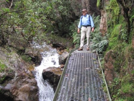
The walking track to Campbells and Ross Lookout leads off from near Bluff Falls, and is signposted Campbells Lookout 700m, Ross Lookout 3.0km; both sound tantalisingly close, but it is hard work getting to both. Terrain on the way includes some steep pinches, slippery rocks and an 18-rung steel ladder. The upward toil reveals another large cascade, as well as some interesting mini-canyons that have been carved by Bluff Creek over the millennia.
The walking track to both lookouts shares a common 30-35 minutes of travel, leading to a signpost, with Campbells being straight-ahead, and Ross Lookout being to the right.
Campbells is the more popular of the two lookouts, and has a steel safety barrier marking the end of the track.
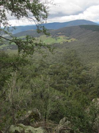
Ross Lookout is for the tough, being a relentless climb up into the high country; take plenty of water and some food on this section as it is quite tiring. As with the lower sections, there are some steep pinches on the way, as well as some slippery rocks to negotiate. On the ascent, it pays to keep stopping to admire the views behind you, and to take a breather.
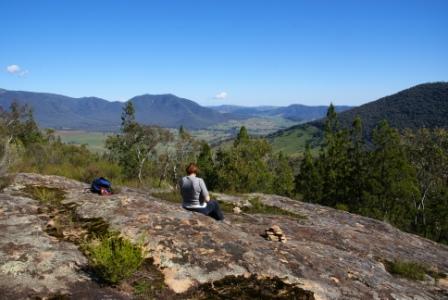
Having arrived at the Lookout, there are several places to admire the view from, with the highest of these producing a neat valley panorama, showing Corryong to the hard left.
Vehicle Access to Ross Lookout
If you want to admire the view from Ross Lookout, without expending all of the energy normally required; it is feasible to drive to within a hundred metres of the Lookout.
All that is required is a good map, and a four-wheel drive vehicle that is not towing a trailer or caravan (not only is there a shortage of space to turn around on this route, but the roadway makes an alpine style ascent/descent, with several very tight hairpin bends).
Setting off from the Corryong area, take the Murray Valley Highway west for about 30km, and then swing right (north) onto Jeffcott and Jewels Road (there are a few variations on the spelling of this).
Veer right at an unsignposted y-junction (two kilometres from the Highway), and then veer right at a y-junction signposted National Park. From here the roadway looks rather un-used, and quite grassy, however this is the correct route, and the roadway should be followed as it disappears into the forest.
Ignore all of the side tracks leading off the main gravel, and continue through to a y-junction at about the 14km mark (GPS 36.08.249s : 148.42.556e). Veer right here (ignoring Black Mountain Track) and follow this through to a small car parking area. Here there is a signpost indicating that Ross Lookout is a short uphill stroll away.
Vehicle Access to Black Mountain
The access route to Ross Lookout can also be used to get to the Black Mountain area, and Hinces Saddle Walking Track.
Follow the Ross Lookout access until you reach the y-junction at about the 14km mark (GPS 36.08.249s : 148.42.556e). Veer left here, and follow this narrow, and little used, track to a small vehicle turnaround at 1220m.
From here Hinces Saddle Walking Track heads off to the north, reaching the Saddle after about 2.5km. This is a nice flat-ish area, and is a popular stop-over for those hardened bushwalkers who trek from the Bluff Falls camping area, through to the Hinces Creek camping area, a walk usually taken over two days.
From Hinces Saddle it is a six kilometre descent down to the Hinces Creek camping area, following Hinces Creek quite closely. The camping area at the bottom is quite small, and will only accommodate a few campers before it loses its ambience.
Road access to this area is by taking the initial route towards Bluff Falls, ignoring the sign-posted left turn to the Falls, and continuing towards Walwa for another 3.5km to a sign-posted left turn to Hinces Creek. This leads to the small camping area previously mentioned, immediately prior to a significant water crossing.
Hinces Saddle can also be used to gain access to the little used Mount Burrowa Walking Track, a venue for expert bushwalkers only.
Pine Mountain [AWTGS-3]
As mentioned above, Pine Mountain has the distinction of being Australia’s largest monolith, and offers some rugged bushwalking, with some nice rewards in the shape of fascinating vegetation cover and amazing views. Access is from the Corryong or Walwa areas.
The Rooftop Map Upper Murray Adventure Map shows the general locality of Pine Mountain, and the VicMap 1:50 000 sheet is Corryong (available in print, and digital format). The Parks Victoria website (www.parks.vic.gov.au) also has some handy PDF downloads, with maps and further information on the area.
From Corryong, take Parish Lane from the western side of town (signposted to Burrowa Pine Mountain National Park). Not far out of town, Parish Lane becomes the Briggs Gap Road, and provides a scenic start to the day, with the bitumen leading over the range from Corryong to the Cudgewa Creek Valley.
Follow Briggs Gap Road through to the C548 (the Cudgewa - Tintaldra Road, about 12km from town) and turn right, following the valley floor route through to the Cudgewa North Road, going off to the left.
This is signposted to the National Park, and leads through cleared farmland, and then a section of the Park, emerging again amongst cleared farmland, with Sandy Creek Road coming in from the right.
Alternative access to this point is via the C547 (Guys Forest / Shelley Road) out of Walwa. This leads south for a few kilometres to where the Sandy Creek Road (shown as the Cudgewa Bluff Road and/or the Cudgewa North - Walwa Road on some maps) heads south at the point where the C547 veers to the right. Keep left at the junction of Sandy Creek Road and Cudgewa Bluff Road, taking the former named roadway.
Follow Sandy Creek Road for about seven kilometres, turning left onto Pine Mountain Track. The signage here says that this is a dry weather only route; to be fair, the words 4wd only should be added to this warning.
Five kilometres of gravel and earthen surfaced track now leads to a farm gate, where there is a small amount of vehicle parking space. Some walkers use this area as a base camp so that they can get an early start to the Pine Mountain walk.
Whilst this venue has forest on three sides, the fourth side is cleared pastoral land, and you may get cattle coming over to check you out. Fortunately, they will be on the other side of a fence, so they will not get too personal.
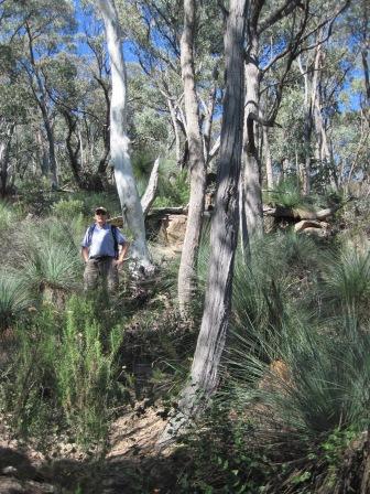
There are several ways of tackling the Pine Mountain area, as there is no need to go all the way to Pine Mountain. Things to consider before setting off include the fact that the route basically follows the spine of the monolith, and has more ups and downs than there are days in the week. This means that you should take a generous allowance of food and water with you, as well as giving the walk a generous allowance of time.
The route is marked out (but not consistently) with the usual red triangles, as well as a number of stone cairns, however you should take a copy of the VicMap 1:50 000 sheet Corryong (in print or digital format) with you, and log waypoints on your GPS as you go. This will help you to monitor your progress, and to recover your sense of place if you get confused.
Setting off from the car parking area there are a number of false trails to choose from; make sure that you follow the red triangles, and do not depend on following what might appear to be a well used footpad.
The closest feature to aim for is Rocky Knob; this takes about 30 minutes to reach, being about 1.5km from the start. Depending on where you stand on Rocky Knob, you will have reached an altitude of about 640m at Rocky Knob, with some good views in several directions.
Continuing on from here leads to what many walkers refer to as Little Pine Mountain. This takes a further 60 minutes to reach, with more ups and downs on the way, as well as several rocky outcrops to ascend, and then descend.
However, the effort is well worth it, as Little Pine Mountain is a fascinating place, with a jumble of huge pink granite boulders to wander through. This is at an altitude of about 920m, with correspondingly great views; if you wander around the boulder field sufficiently you will have almost got the 360 degree coverage.
If you are tackling Pine Mountain itself, the walking track now continues for a further six kilometres, taking up to two hours to reach.
Overall, this is a strenuous venue, but one of the best ridgeline walks in Victoria.
Intro Screen on a fresh browser page
COPYRIGHT © 1995-2020, Chris McLaughlin.