BIKE PATHS, RAIL TRAILS and CYCLE ROUTES
(www.northeastvictoria.online)
MOUNT BEAUTY TOWN LOOPS
Mount Beauty (population about 2300) is located on the Kiewa River, and is set in a beautiful valley, with excellent views of Mount Bogong.
The township has a good array of shops and services, centred around Hollands Street, as well as motels and some small restaurants. The township, like many others in and around the high country was purpose built as part of a hydro-electric scheme, the Kiewa Scheme in the case of Mount Beauty.
There are two local rides described here; the first loops around the Regulating Pondage, and the second takes you out to the village of Tawonga, just north of Mount Beauty.
The Pondage
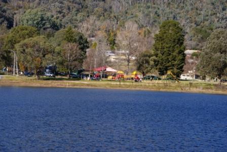
The Mount Beauty Pondage is adjacent to the town of Mount Beauty and is used to regulate outfall from the Kiewa Hydro-electric Scheme into the Kiewa River. For pedestrians it provides the perfect setting for an enjoyable 50 minute walk; for cyclists an enjoyable 15 minute ride.
Leave your vehicle at the small picnic/barbeque area (Bicentennial Park) off Lakeside Drive, Mount Beauty. The ride starts (when standing and facing the water) by heading off to the right; the track goes behind the Shire Offices and then the lakeshore can be followed all the way round the lake.
The walking/cycle track initially follows the embankment that forms the lake and this leads to the outlet gates (spillway) of the lake. There are several benches at strategic intervals along the embankment so there is plenty of opportunity to sit and admire the view.
A short diversion is necessary at the outlet gates, down the embankment, across the outlet gates plume, and then back up onto the embankment. This leads to a grassy area and from here head over towards the fence of the Hydro Works Area.
Turn left at the fence to pick up the walking track once more. The track turns left after about 100m, where it meets the Tail Race Channel of Kiewa Power Station No 4, crossing the Tail Race via a pedestrian bridge. Once over the bridge, turn right and then left to pass behind Mount Beauty High School.
The track meanders past the school and then the tennis courts. The cricket ground is next, and then the track moves left and crosses a short section of park, leading back to Bicentennial Park.
Total distance is about four kilometres (15-20 minutes), making this a nice warm-up ride for something bigger.
Mount Beauty - Tawonga
This 20km ride (60 minutes / 10km each way) follows a dedicated walk/cycle path alongside the Kiewa Valley Highway, and is a very enjoyable half-day outing, with many great views of the surrounding high country. Great care is required at each of the points where the pathway crosses over the Highway.
Starting off from just near the bridge over the West Kiewa River, the pathway is initially on the right side of the bitumen, and crosses over to the left side just after the last group of shops.
The ride now starts to involve a little bit of elevation gain, and soon emerges alongside the Tawonga South residential area. This is also accompanied by some nice views of Mount Bogong (to the right).
As you approach the turn-off to Bright (the C536) the pathway crosses back over to the right side of the Highway, and remains on this side all the way to Tawonga.
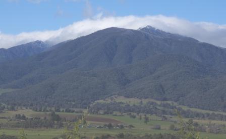
A viewpoint of Mount Bogong is passed (a good place to stop for a quick drink) and from here it is an undulating ride to the Ryders Lane turn-off (to the right).
If you want to go down to the Kiewa River at this point (or the Tawonga Caravan Park), the Kiewa River is about 1.2km from the Highway, along a designated walk/cycle path on the left-hand side of the bitumen. The bridge over the Kiewa is adjacent to the Tawonga Caravan Park (to the left as you cross the bridge) and there is a nice picnic area to the right of the bridge.
Continuing towards Tawonga from the Ryders Lane turn-off, it is a further three kilometres to the village, where the Tawonga General Store serves a welcoming tea or coffee.
Intro Screen on a fresh browser page
COPYRIGHT © 1995-2020, Chris McLaughlin.