
BIKE PATHS, RAIL TRAILS and CYCLE ROUTES
(www.northeastvictoria.online)
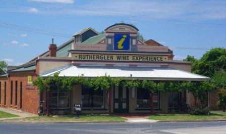
WANGARATTA to RUTHERGLEN
There is currently no dedicated cycling route from Wangaratta to Rutherglen, so the choice of route to take is largely a matter of balancing personal choice and safety considerations.
The original railway cut across to Rutherglen from the Melbourne - Sydney Line at Springhurst, and most of the tracks are still in view from parts of the Springhurst - Rutherglen Road (the C376). So it is technically possible to closely follow the old rail route (details at the end of this section); however, a safer option is to take a short part of the Murray to the Mountains Rail Trail, and then swing to the north at Bowser, taking some nice back country roads to Rutherglen.
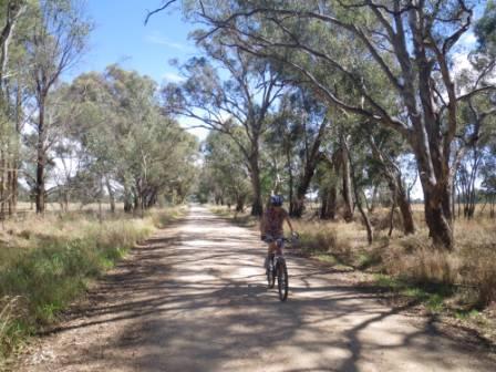
Given that much of this ride is on a gravel surface, this ride is not recommended for road bikes; mountain bikes are best, with hybrids being a good second choice, given that they have good quality tyres (and tubes) fitted. As well, the road signage in this part of the North-east is not the best, so we have included some benchmark distances, and some GPS readings, to prevent you getting confused out there.
We used Rooftop Maps Beechworth - Albury - Wangaratta Adventure Map to find our way around, and other than some road classification anomalies, did not find any errors in this map. The GPS readings are quoted in degrees and minutes (to three decimal places).
So as to make this description easy, we have included some of the text of the Murray to the Mountains Rail Trail description at this point.
The Murray to the Mountains Rail Trail officially starts at Apex Park, just over the Ovens River Bridge, which itself is just north of the CBD. There is plenty of room for parking, and unloading here, as well as picnic amenities and a toilet block. Getting to Apex Park from the CBD either involves mixing with traffic in Murphy Street, and then taking the main Ovens River Bridge (which is quite narrow); or taking the slightly quieter Ovens Street, and then taking the Bickerton Street suspension bridge over the Ovens (the suspension bridge carries pedestrian and bike traffic only).
Starting off from around Merriwa Park involves following the flood levee through to Chisholm Street, then swinging into Faithfull Street, crossing the Mitchell Bridge (over the Ovens River) and then picking up the Rail Trail on the north side of the Bridge.
If you are starting your journey from Wangaratta’s railway station, then the Rail Trail is quite clearly signposted, and these will guide you from the Station to the suspension bridge. Just opposite the station, Cafe Derailleur can provide some nice refreshments to kick off your adventure.
Once at Apex Park, the Trail leads off through an underpass of the Ovens River Bridge, and then swings left at the Ovens River / King River confluence, before getting up to speed along one of Wangaratta’s many flood levees.
The Trail then crosses the Great Alpine Road (GAR, take care) and heads north, basically following the old Hume Highway, and then the original Hume Highway, before emerging at the Vine Hotel. This is one of Wangaratta’s oldest pubs, and was a haunt of the Kelly Gang in the bushranger era. In the modern era it serves a great meal.
From the Vine, the Trail veers left, and continues to follow the old Hume Highway northwards to Bowser Station (this is about seven kilometres north of town). This was a major signalling station in the old days, but was dismantled when the Bright and Beechworth Railways were discontinued (it was known as Beechworth Junction until 1922).
Turn left at Bowser, carefully crossing the Old Hume Highway, and taking the C375 turn-off (signposted to Corowa, and designated ’Federation Way’). Once over the Highway, take care at the Melbourne - Sydney rail line, as there are no gates here.
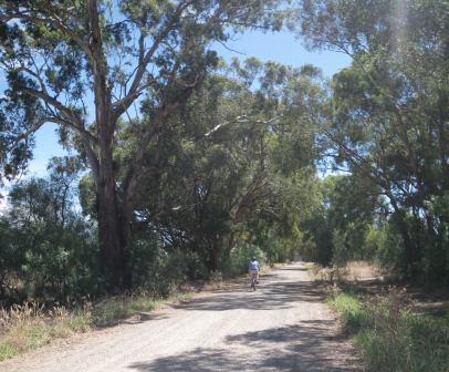
A very short run along Federation Way leads to a left turn onto the gravel of Back Estcourt Road, and a nice rural run of a little over five kilometres to an off-set cross-roads.
The straight-over option at these cross-roads looks like a farm gateway, but it isn’t. Turn left at the cross-roads, and then almost immediately turn right, a manouevre that keeps you on Back Estcourt Road. This is another scenic section of roadway, with some nice views of the Warby Ranges to the left.
Swing right onto O’Keefe Road at the eight kilometre mark (GPS: 36.15.233S 146.19.110E), ready for another great section of tree lined country road. Keep straight-ahead at the Bolland Road cross-roads (10.4km), with the roadway now starting to slope down into the catchments of Daddah Daddah and Diddah Diddah Creek.
There are several wetland sections to be traversed along this stretch, however, except in very wet conditions, there will be no water over the roadway along here, just plenty of waterbirds to look out for.
Keep straight-ahead at an off-set cross-roads (at about 15km) and continue through the Boorhaman - Springhurst Road at about 16km (GPS: 36.10.710S 146.19.985E) where the route for today swings to the right.
This puts you on slightly wider roadway than before, but the scenery is still good, with many ancient redgums lining the route as you basically follow Daddah Daddah Creek upstream. There are also some nice distant views of Mount Buffalo (to the right) at several points along here.
Federation Way is crossed over at about 21km (take care), with the route continuing to follow the Boorhaman - Springhurst Road for another three kilometres to a cross-roads at the Booralma - Rutherglen Road (shown on some maps as Sheridans Bridge Road). The route swings to the north at this intersection, so a left turn is required here, ready for some more great rural cycling.
The said Sheridans Bridge is encountered at about the 31km mark, with the Noorong Road cross-roads being at about 32km. Rutherglen is getting close, and you need to turn right at this intersection, the last but one major change of direction on this ride, the GPS at this point being 36.06.536S 146.26.262E.
Continue along Noorong Road, and take the left turn at a minor cross-roads at about the 35km mark (GPS 36.06.733S 146.27.883E). A useful landmark at this point is that having turned left here, you should be able to see a radio tower on the distant diagonal left, and a large food processing works to your immediate right.
You are now on Slaughterhouse Road, and at about 37km there is a five-way intersection, where you need to keep straight-ahead, and brace yourself for some hillwork on the final approach to Rutherglen.
Scion Winery is passed at about 38km, and soon after this the bitumen is encountered, followed by some more slopes before meeting up with Sheridans Bridge Road once more. At this point the route becomes High Street, and this is now followed through to the centre of town, only a few hundred metres away.
Total distance from Bowser is about 42km, with travel time being about three hours (add about eight kilometres, and 30 minutes if you are setting out from the centre of Wangaratta).
See the separate description of the Rutherglen - Wahgunyah Rail Trail for an extension of this ride to the Murray River.
Following the original railway tracks
The railway from Springhurst to Rutherglen and Wahgunyah opened in 1879, and was finally closed in 1978. If you want to follow the original route of the line, then you need to cross over the old Hume Highway at Bowser (take care), as well as the Melbourne - Sydney rail line (take care at the crossing, there are no gates here).
Immediately after crossing over the railway tracks, turn right onto the unsealed Railway Road, an aptly named roadway that follows the rail tracks all the way to Springhurst.
Railway Road stays fairly close to the rail tracks, crossing over various side roads in the process; take care at each of these cross-roads, not all of them have Give-way or Stop signs.
Once within the environs of Springhurst (18km from Bowser), keep straight-ahead where Railway Road dives off to the right to pass under the railway tracks, and follow the bitumen through to the main part of Springhurst township (note that there are no shops or services in Springhurst).
Just opposite where Railway Road heads off to the right, take a few moments to admire the ornates lines of the former Springhurst Butter Factory - now a private residence.
The C376 (the Rutherglen Road) is encountered on the other side of the township area, and all that remains to be done now is to swing left at this point, and follow this busy-ish stretch of bitumen through to Rutherglen. This is not a particularly safe part of the route, and you should be equipped with a brightly coloured safety jacket, as well as a rear vision mirror. Also, be prepared to pull off the bitumen (onto the gravel shoulder) as the need arises.
Finally, as you get close to Rutherglen, the disused railway tracks are visible to the right; hopefully this strip of land will soon host a busy bike trail.
Intro Screen on a fresh browser page
COPYRIGHT © 1995-2020, Chris McLaughlin.