BIKE PATHS, RAIL TRAILS and CYCLE ROUTES
(www.northeastvictoria.online)
WANGARATTA to OXLEY and MILAWA
There is now a dedicated cycling route from Wangaratta to Oxley, and on to Milawa, with a gravel pathway under your wheels all the way. The route starts in the south-west corner of the Wangaratta urban area, and basically follows the tracks of the now defunct Wangaratta - Whitfield Railway to Oxley, and then swings north on its way to Milawa.
The initial run follows Murdoch Road (which becomes the C521, the Wangaratta - Whitfield Road), however the designated bike route is actually in the service road, not on the main stretch of bitumen. This soon morphs into the bike path proper at Cribbes Road.
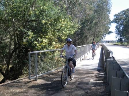
[Many riders use Wangaratta’s One Mile Creek Bike Path (see separate description) to access the start of this great ride. Having reached the end of the One Mile Creek Bike Path (at Cribbes Road), turn left, and follow this suburban street through to the C521. Turning right at the C521 puts you on the tracks of the now defunct Wangaratta - Whitfield Railway, with the designated (and segregated) bike path being on the west side of the roadway at this point.
Alternatively, cross over the creek bridge on Cribbes Road, then take an-unsignposted right turn that leads (for about 400m) through to the base of Wenhams Lane (a no-through road). You can then follow Wenhams Lane for about 100m, and pick up a gravel pathway that runs parallel to the bitumen of Wenhams Lane.
Then take the gravel pathway to the right, and follow this through to a y-junction, with gravel to the right, and a single file sealed pathway straight-ahead.
Follow the sealed pathway through to an open stormwater drain. Swing left here, and follow this designated walkway through to the environs of the Sports Complex adjoining Cathedral College, taking care in crossing the two roadways on the way.
This brings you out to Murdoch Road, where a right turn is required, and from here the bike path stays on the west side of the roadway for a about 1.5km, before crossing over to the other side in preparation for passing under the Hume Freeway.
Having crossed over the bitumen, the bike path continues to follow the C521 for about a kilometre, and then swings abruptly to the left just before the environs of the Hume Freeway. The path then gradually drops down, ready to swing right under the Freeway, joining up with a segment of the King River on the other side of the underpass.
A short climb then brings you back to the C521, and a few hundred metres later there is yet another change of side, with the bike path now being back on the west side. This continues until the route meets up with the Snow Road (the C522) at the Oxley Cross Roads.
Cross over the Snow Road, and follow the bike path for a short distance where it makes its final crossing of the C521.
A short distance down the Snow Road, Sam Miranda Wines are on the left, and as well as an excellent vintage, has a popular cafe, with an alfresco dining area. Details in the Winery Listing.
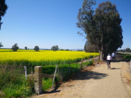
Continuing on, the C522 crosses a section of the King River where there are numerous flood channels and billabongs to admire. A small rest area near the River (on the right just before the main bridge) is a popular picnic venue, and is named after Oxley local, Stan Allan.
The small township of Oxley (11km) is also just beyond the King River Bridge, and is supposedly the second oldest place name in inland Victoria (after Mount Buffalo). Explorer Hamilton Hume named Mount Buffalo a day before he came upon and named the Oxley Plains. He chose the names because Mount Buffalo does in fact look like a buffalo from certain angles, and the Oxley Plains were named after surveyor-general John Oxley, this was on 26th November 1824.
In the modern era, Oxley is home to the excellent King River Cafe, well known for its extensive menu and good service.
Click here for more details about King River Cafe.
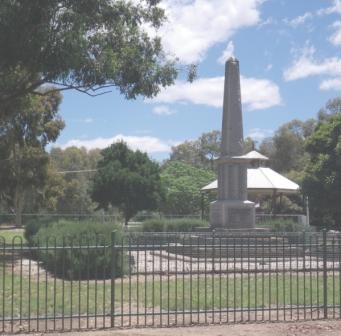
If you are self-catering whilst on the bike trail, Oxley has a nice picnic area, centred on the War Memorial Gardens.
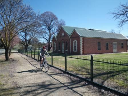
Oxley also has an interesting collection of historic buildings. The Shire Hall, for example, was built in 1875 and, now classified by the National Trust, is one of the oldest buildings in the Shire. Land was set aside for a hall in 1868, and the building was commissioned in 1873. Another old building, the Oxley Flour Mill was built about 1868; at 106 years old it has the same National Trust classification as the Shire Hall. Other buildings of historical interest include the Methodist Church (1885) and the Baptist Church (1890).
Continuing on from Oxley, the next town en-route is Milawa, where the cross-roads are always busy, with many interesting gourmet food possibilities at hand.
On the left corner as you approach the cross-roads, the Milawa Hotel has an excellent menu, and is well known as a good place for lunch and dinner. The adjoining caravan park is quite small, but with a great position.
On the right corner, the excellent Ava Restaurant occupies the former Bank of New South Wales building, and is a popular venue for dinner. On the left, a former Cobb & Co Depot is now home to Henley's Restaurant, a popular place for lunch.
Just beyond this, there is a pharmacy, followed by the Milawa Bakery and The Olive Shop, showcasing olives from many of southern Australia's wine growing areas.
Total distance to the cross-roads from Wangaratta is about 20km, depending on which part of the CBD you set out from.
Turning right at the cross-roads leads to the well known Brown Brothers Winery; well worth a visit at any time of the year, and always popular for its fine wines, and collection of historic buildings. The restaurant at Browns serves up one of the best meals in Victoria, with great ambience; contact details are in the Winery Listing on the HomePage.
If you have the time, turning left at the Milawa Cross-roads leads (on a continuation of the bike path) for about two kilometres to the Milawa Cheese Factory, a very popular destination that serves up morning tea, and light lunches. A wide range of local produce (including all those tempting cheeses) is also on offer in the retail section.
Getting to the Bike Path from Wangaratta Railway Station
If you are starting your journey from Wangaratta’s railway station, then Cafe Deraillieur is diagonally opposite the station, and serves a nice morning tea/lunch.
However, to get to the Bike Path, you need to turn left from the station forecourt, and head towards a water tower, about 200m away. Swing around to the left alongside this historic structure, and take the foot bridge that leads over the railway lines.
This leads to the northern part of Docker Street, which you can then follow through to Swan Street, about 400m away.
Take care as you cross over Green Street, as the adjoining hospital, and other medical facilities in this area, generate quite a bit of traffic (a busy area by Wangaratta standards).
Turn left at Swan Street, and make your way a very short distance to a bridge over the Creek.
Take the slip track down to the left, and you are now on Wangaratta’s One Mile Creek Bike Path which can now be followed through to Cribbes Road. See the separate description of this pathway for more details.
Intro Screen on a fresh browser page
COPYRIGHT © 1995-2024, Chris McLaughlin.