BIKE PATHS, RAIL TRAILS and CYCLE ROUTES
(www.northeastvictoria.online)
HIGH COUNTRY RAIL TRAIL
The High Country Rail Trail currently runs from Wodonga to Tallangatta and Shelley, albeit with a gap before getting to Shelley. An informative brochure on the Rail Trail is available from Visitor Information Centres in the North-east; see also the official website for the Trail (details below)
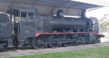
The Wodonga - Cudgewa Railway ran through some of Victoria’s best scenery and operated, in one form or another, from 1887 to 1978. The first passenger service on this line ran from Wodonga to Huon, a branch line that linked some small farming communities along the Upper Murray River, long before the days of Lake Hume. Huon is now a lakeside village, and its train service dated back to 1887.
Soon after reaching Huon, work was started on extending the line to Tallangatta (this was the old township of Tallangatta, not the new one created in the mid-1930s), with the new section of line being commissioned in 1891. This new section included an impressive trestle bridge over the Mitta Mitta River (now the Mitta Mitta inlet of Lake Hume), and the first train rolled into Tallangatta on June 1st 1891.
There was now a hiatus in extending the line any further east, as there was some unfriendly topography in the way. However, work on the Cudgewa extension began in 1914, with Shelley Station being completed in 1916, and Cudgewa in 1921. Shelley Station then had the honour of being the highest railway station in Australia, an impressive 780m. The locomotives at this time were steam driven, and these held sway over the diesel-electric motor until the late 1960s. Passenger services ceased in the early 1960s, and the freight service ceased in 1978.
The line serviced the communities of Bandiana, Bonegilla, Ebden, Huon, Bolga, Tatonga, Tallangatta, Bullioh, Darbyshire, Koetong, Shelley, Beetoomba, Wabba and Cudgewa; it was a major employer in the area, particularly during the Great Depression. Several significant modifications were required to the line during its 80 year life span; for example, a new bridge over Sandy Creek was required when Lake Hume was built (mid 1930s), and several stations had to be re-sited for the same reason (notably Tallangatta station). The Sandy Creek Bridge was later modified, this time because the dam wall of Lake Hume was raised, and the Lake’s waters were lapping at the sleepers.
Parts of the old railway have now been converted into the High Country Rail Trail, and starting out from Wodonga, the Rail Trail officially begins at Bandiana, on the Murray Valley Highway, just east of the main urban area of town.
Some brochures say that the Trail starts at the Kiewa River, but in either case, several of the bike routes in Wodonga link up with the Rail Trail; the Wodonga Urban Rides section has the details.
Wodonga has an altitude of about 155m, whilst Bandiana is at about 175m, and the Kiewa River is at 160m, and this sets the scene for the rest of the Rail Trail - nearly as many ups as there are downs, but given that this is the former route of a slow train, all of the gradients are quite gentle, and there is nothing too strenuous out there.
Setting out from Anzac Parade, just east of the Brockley Street intersection, there is a short run of bike lane to traverse, and this is then followed by the Rail Trail proper, a nice bitumen sheeted run of about seven kilometres alongside (but separated from) the Murray Valley Highway. The surface then changes to gravel as the Rail Trail swings to the right at Whyte Street and meanders over the flood plain of the Kiewa River.
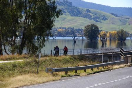
Bonegilla (and Lake Hume) come into view after this, and from here (Bonegilla) there is an excellent 11km run along the lake foreshore, all the way through to Sandy Creek Inlet. The picnic/barbeque areas at Ebden, Ludlows Reserve and Huon provide some easy access-egress points if you just want to complete some short sections of the Rail Trail.
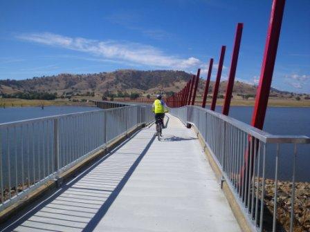
The Cudgewa trains used to pass straight over the Sandy Creek Inlet Bridge, and a new bridge has now been constructed over the Inlet, and this is one of the highlights of the ride.
Once at the eastern side of the Inlet, it is about eight kilometres to the lakeside township of Tallangatta, with the Rail Trail passing immediately to the south of the urban area.
If required, getting into town is easy, with a signposted turn-off leading to Banool Street, and the main shopping strip.
There is a good range of shops, services and accommodation on offer if you want to linger a while. Along the waterside at Tallangatta, Queen Elizabeth Drive is a designated bike route, and offers a nice easy ride with great views.
Continuing east from Tallangatta, it is about six kilometres to Tatonga Inlet (where the Mitta Mitta River enters Lake Hume), and a further two kilometres to Old Tallangatta, and another gap in the Rail Trail. This is where the old steam locomotives used to earn their keep, taking passengers and goods on a long ascent up into the high country around Shelley.
As mentioned above, Shelley had the honour of being Victoria’s highest railway station, and is substantially higher than any other part of the Rail Trail. For this reason it is best to treat the Shelley Station section as a downhill run, preferably with someone to shuttle the vehicles around so that you don’t have to go back uphill. As well, given the nature of the trail in this area, the preferred mode of transport is a mountain bike, or a hybrid with some good tyres and tubes.
Vehicle access to Shelley is by turning off the Murray Valley Highway onto Avondale Road; this is about three kilometres east of the C547 intersection (the C547 is the Shelley - Walwa Road). From the Highway it is a short run (on gravel) to where Station Street goes off to the right. This almost immediately splits, with Railway Terrace being the left part of a y-junction. Follow Railway Terrace for a few hundred metres, to a sharp right-hander, which then leads into what was formerly the Shelley Railway Station Yards.
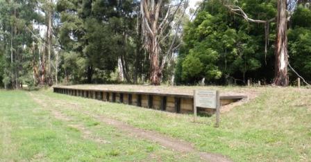
The Station here was opened in 1916, and closed in 1979. It was a hive of activity for many years, but all that remains today is the platform and the railway cuttings, where trains where shunted up and down the yards seven days a week.
Setting off from Shelley, it is time for some freewheeling, with the gradient providing most of the energy required for this section. However, you need to dismount for the three trestle bridges near Koetong (and walk around them) followed by a careful walk across the Murray Valley Highway near the historic Koetong Hotel.

To the west of the Hotel, it is necessary to ride along a short section of the Murray Valley Highway; this is to get around a stretch of Rail Trail that is untrafficable because of the Boggy Creek Trestle Bridge. The Bridge is accessible via a signposted detour (to the right when heading towards Tallangatta) and is very photogenic.
Continuing westwards, the slope is mostly downhill, and the site of the former Darbyshire Station is passed by, followed by some ’crossings’ of the Highway via underpasses.
Finally, the Trail finishes abruptly, at a small roadside cutting, where (hopefully) your transport is waiting for you.
HIGH COUNTRY RAIL TRAIL WEBSITE
Intro Screen on a fresh browser page
COPYRIGHT © 1995-2020, Chris McLaughlin.