LAKE COBBLER
(www.northeastvictoria.online)
TRAVELLING TIME: At least three hours (from Cheshunt or Myrtleford).
DISTANCE COVERED: 75km (from Cheshunt or Myrtleford).
OVERVIEW MAPS: Spatial Vision, Touring the Victorian Alps.
DETAILED MAPS: Rooftop Maps, Bright - Mansfield Adventure Map. The VicMap 1:50 000 topographic maps for this tour are Buffalo, Buller, Selwyn and Whitfield; these are available in print, and GPS (digital), format.
SHOPS and SERVICES: Wangaratta and Myrtleford are the closest main commercial centres to the start of this tour, and both offer a good range of shopping and services. Once in the King Valley, there is a general store, a hotel, cafes and a fuel outlet at Whitfield, and a cafe at Cheshunt.
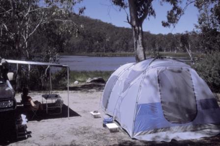
ACCOMMODATION: Commercial camping areas (and a range of other accommodation options) at Wangaratta and Myrtleford. Commercial caravan parks (and motel units) at Whitfield. Excellent bush camping at Lake Cobbler.
WHEN TO GO: Avoid any sustained wet weather, and any super-hot days.
ROADWAY DETAILS: Generally good bush roads, although quite narrow. No problems in the dry for any vehicle; the route is not recommended for caravans; camper-trailers should be 4wd rated. Note that maps of this area show several alternative routes to/from the Lake; all of these alternative routes require a 4wd vehicle with high ground clearance and low range gears - the route described is the only one suited to non-4wd vehicles.
OTHER INFO: A great part of Victoria, with plenty to see and do. Distances quoted may vary by several kilometres from one vehicle to another.
Lake Cobbler is a small, artificial lake nestled in the High Country; it was created in the 1960s by damming a swamp area in the headwaters of the Dandongadale River. After leaving Lake Cobbler the Dandongadale River plunges over a precipice, creating the longest drop waterfall in Victoria (a heady 255m).
It then joins the Rose River, which flows into the Buffalo River, before settling down to a quiet life in the backwaters of Lake Buffalo. The Lake is a popular touring destination, as well as a good base camp for lazy days, and/or walking to nearby Mount Cobbler.
Cheshunt Access
From the King Valley, access to Lake Cobbler is via the Rose River Valley (Dandongadale) Road east from Cheshunt, the turn-off to the Lake being about 14km from Cheshunt.
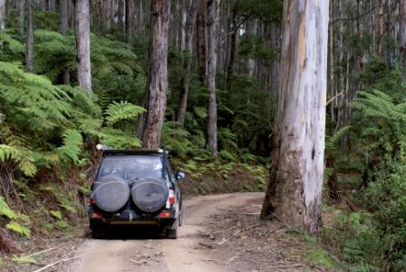
The final access road is known as the Upper Rose River Road, Cobbler Lake Road and Lake Cobbler Road depending on whose map you are using. The turn-off is on the right, and is not very clearly marked. From the turn-off it is a two hour trip in, and a two hour trip out, with a total distance of about 60km.
On the way to the turn-off the route passes the access to Paradise Falls, about two kilometres out of Cheshunt. These are very pretty and are worthy of the short drive to get to them (see additional text at the end of the main description).
See the King Valley Tour for initial access to Cheshunt.
Myrtleford Access
Coming from Myrtleford, access is via the Buffalo River Road. This follows the Buffalo River for a while, crosses the Lake Buffalo Spillway and then heads to the backwaters of the Lake before swinging west onto the Rose River Valley (Dandongadale) Road; the turn-off being about 49km from Myrtleford.
The final access road is known as the Upper Rose River Road, Cobbler Lake Road and Lake Cobbler Road depending on which map you are using. The turn-off is on the left and is not very clearly marked. From the turn-off it is a two hour trip in, and a two hour trip out, with a total distance of about 60km.
Upper Rose River Road
Having turned onto the Upper Rose River Road (which leads to the Lake) this bush track initially passes through partially cleared grazing country, including the historic property of Bennies (10km).
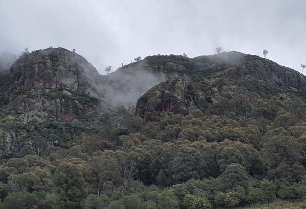
The fascinating and distinctive bee-hive outcrops of Mount Typo appear adjacent to Bennies and these make an interesting photograph. They are reminiscent of the Bungle Bungles in Western Australia, and the Grampians in western Victoria.
Mount Typo Station is run as a holiday, and support, camp for young people, and is a well known institution in the King Valley; details at www.acre.org.au.
The Bennies were a Whitfield farming family since the 1860s, and James Alan Bennie was born at Whitfield in 1895. He subsequently served with the Australian Army in France and Belgium, and in 1919 bought a large block of land adjoining Mount Typo, where he built his home Rivermount.
This became a landmark institution in the high country as the Bennies were renowned for their hospitality, and knowledge of the area; they provided transport and food supplies for many anglers and bushwalkers throughout the 1930s, 40s and 50s. Bennies wife died in 1962, and James Bennie passed away in 1968. Subsequently, vandals burnt the homestead to the ground.
There is a popular riverside camping area at the homestead site, as well as an enjoyable walking track for experienced bushwalkers. This 12km there-and-back walk [AWTGS-3] heads south from Bennies, leaving the Rose River, before joining it again a few kilometres later. The track then crosses the River several times before terminating at an old forestry hut (where Wild Horse Gap Track crosses the River). Allow 4-5 hours for the full walk (and a reasonable amount of effort), but it is not necessary to complete the full walk to have an enjoyable time.
Continuing on by vehicle, the access road takes an abrupt swing to the left just after Bennies (take care, this is easy to miss) and begins its relentless climb to the Lake.
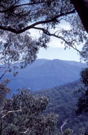
There are great views to be had on the climb, mostly for the benefit of passengers. As well, the Road is quite narrow and it is wise, given the popularity of this route, to be on the lookout for other vehicles.
Watch out for access to views of Dandongadale Falls as you drive up to the Lake, they appear on the right after crossing the Dandongadale River, about three kilometres before the Lake camping area is reached. Another marker is the Abbeyard Track turn-off, the viewpoint to the Falls being about 1.5km after this intersection.
There are three separate drops here, a mini twin falls on the left, and the main drop on the right, all very scenic (subject to water, of course).
Finally, after about 29km a small intersection is reached, signposted Speculation Road to the left, and Lake Cobbler to the right. The Lake is now in view (down to the right) and the Road skirts the lakeshore, crossing the miniscule (at this point) Dandongadale River before emerging at the main camping area.
There is plenty of flat ground on this side (the west side) of the Lake, so it is easy to spread out, and not be too close to any neighbours.
At the Lake
Entertainment at the Lake includes great camping; a walk to Mount Cobbler (about two hours each way); a walk to the upper rim of the waterfall (not recommended for children); lazing in the Lake, and lazing in the River above the Falls, where there are some neatly sculptured spa baths. As this is such a scenic location, with plenty to do and see, it is worthwhile planning to stay a few days.
The upper rim of Dandongadale Falls can be reached by basically following the River downstream, a poorly marked track will assist you. However, there are several false leads off to the left.
The walk to Mount Cobbler (1650m) is very rewarding with great views of the surrounding high country from the summit. In spring and early summer the wildflower display is impressive. Take plenty of water and some food as the walk is quite strenuous [AWTGS-4].
The start of the walking track leaves the camping area about 50m east of the Cobbler Hut, and a signpost advises that you allow one and a half hours each way for the walk; however, you may find that four hours for the return trip (a total of about 10km) is a better guide.
Once on the track, the route is quite well marked with the usual orange triangles on trees. About 20 minutes into the walk there is a single log bridge crossing the creek, and about ten metres downstream of the log there is a pleasant swimming-cooling off spot.
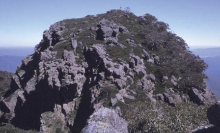
At the top of Mount Cobbler the views are magnificent; a full 360 degree view of the surrounding high country! As you approach the summit, note that you will not be accessing the rocky outcrop on which the trig is located (accessible only to rockclimbers!) but the one beside it.
Refer to Cattlemen and Huts of the High Plains (by Harry Stephenson) and the excellent book Huts in the Victorian Alps (by Klaus Heuneke) for more detail on the Cobbler Hut. Cattlemen and Huts of the High Plains has been out of print for many years, but many libraries still have a copy (when it was in print, it broke all records for sales of a self-published book in Australia).
After enjoying a stay at the Lake, you need to make a u-turn, and head back down into the King Valley, via your incoming route, with the option of a side trip to Paradise Falls.
Paradise Falls
Paradise Falls make an interesting side trip (a 22km loop) from the lower part of the access route to Lake Cobbler via Cheshunt. The Falls are a series of spectacular u-shaped waterfalls on Stony Creek, a tributary of the King River, and are clearly signposted on the Rose River Road out of Cheshunt (a right turn when heading out of Cheshunt).
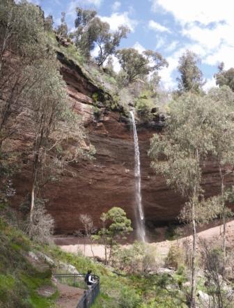
From the turn-off, the meandering access road leads to a car park and picnic area set in an area of dry, open forest, with no inkling of the moist, spray filled gully a short walk away. The access road is quite narrow in places, and subject to inundation; ironically, when the Falls are at their best, the access road is impassable.
At the end of the access road, the walking track to the Falls [AWTGS-2] is signposted from the car parking area, and winds its way through open forest, gradually descending off the plateau, to meet with Stony Creek and its secluded waterfalls.
There are two major falls here, both quite similar with each watercourse having cut a semi-circular arc through conglomerates and sandstones. This has created an extensive overhang in each case and it is quite easy to walk or sit under the waterfalls, and take a refreshing shower every few minutes. Little Falls have a straight drop of 17m, whilst Paradise Falls have a drop of 31m.
The return to the car park is via the same route, and after the walk it is pleasant to take advantage of the picnic-barbeque facilities near the car park (great views).
Intro Screen on a fresh browser page
COPYRIGHT © 1995-2020, Chris McLaughlin.