
MOUNT BEAUTY WALKS
(www.northeastvictoria.online)
Survey Track
Survey Track formed part of the original route to the Bogong High Plains in the early days of the Kiewa Hydro-electric Scheme. In the modern era, it provides an interesting 8.5km walk from Mount Beauty, and is rated AWTGS-3. As well as the great views, Survey Track is also noted for its springtime wildflowers.
There are several variations to this walk, the one described here is probably the most scenic.
A formal pair of walking shoes/boots are required, as well as a set of trekking poles.
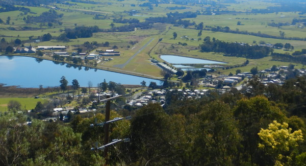
Starting out from the environs of the town centre, pick up Tawonga Crescent so as to head upslope to an informal car parking area, just beyond the Golf Club.
From here, the track initially parallels the Bogong High Plains Road, but then cuts loose to do it’s own thing as a beautiful single file track that leads around the valley slopes.
Take the left turn that lead down to the East Kiewa River rockpools at about 1.2km, and follow this footpad as it winds its way down to the valley floor.
Having reached a t-junction, near the River, turn right, and follow the sign-posted footpads that lead to Mermaid Beach, and The Rockpool - both of which are great places for morning tea.
Retrace your steps back to Survey Track, turn left, and follow this route again as it climbs, and descends, several times on it’s way to a hairpin bend on the High Plains Road called Cranky Charlie.
Also, on the way, you need to keep straight-ahead at all of the junctions with minor gravel roads (these are ‘Management Vehicles Only’ tracks); that is, stay with the main footpad.
After several kilometres of amazing views, there is a handy bench seat, with great vistas of Mount Bogong, that makes a handy rest stop, and from here Cranky Charlie is not too far away.
From Cranky Charlie, there are two options; either retrace your steps (ignoring the detour down to the East Kiewa), or continue towards the bitumen of the High Plains Road, so as to pick up the route known as Pole Track ; see below for more details.
The return via Survey Track is the most scenic option, and (as mentioned above) overall distance is about 8.5km, the time required being about four hours.
The route covered here is shown (in basic detail) in the walks brochure available from the Visitor Information Centre.
[If you want to complete a loop from Cranky Charlie, carefully cross the bitumen, and follow the West Kiewa Power Station Road (unsealed; be alert for the occasional vehicle) for about 700m to the sign-posted turn-off (to the right).
The signage at this point indicates that Mount Beauty is about 3.4km away, via Pole Track, and that you need to stay on this particular track (that is, do not take any of the mountain bike tracks, nor any other vehicular track).
The route now makes a slow descent (with a few undulations) back down to the environs of Mount Beauty, with many excellent views on the way.
At the end of this vehicular track there is a three-way intersection; the hard right leads to the Mountain Bike Park, the soft right leads down to the main area of the town, and the left turn leads down to the Visitor Information Centre.
Taking the soft right option leads past the boutique Svarmisk Accommodation, and then the Bogong High Plains Road, where a careful crossing of the bitumen leads to Park Street, and the town centre.]
COPYRIGHT © 1995-2020, Chris McLaughlin.