MOUNT BEAUTY WALKS
(www.northeastvictoria.online)
Mount Bogong [AWTGS-4]
As previously mentioned, Mount Bogong is Victoria’s highest peak (1986m) and deserves respect; the walk described here involves steep terrain, and a fair amount of time in an alpine environment that has claimed several lives in the not-too-distant past.
Walkers on this route should be well equipped, and reasonably experienced in alpine walking conditions; walking poles are highly recommended. Navigation wise, you will need a waterproof GPS (such as a Magellan Triton) and a copy of Spatial Vision’s map Bogong Alpine Area.
If this is to be a day trip for you, then you should allow a very full day, with an early start to allow for any unforeseen delays and/or the opportunity to linger in the summit area.
As with the previous walks, this adventure starts at the local gateway to the Alpine National Park, at the Mountain Creek Picnic/Camping Area. Access is from Mountain Creek Lane, which leads off the Kiewa Valley Highway, adjacent to the former Bogong View Hotel in Tawonga South.
The walk to the summit begins from the track at Mountain Creek car park, and except in peak periods, there is ample parking space for cars at this point. Don’t forget to fill in the intentions book before setting off!
The route described here uses the Eskdale Spur Track for the outgoing section, and The Staircase Spur for the return to the car park.
Many walkers prefer to use The Eskdale Spur for both, as this offers a gentler gradient, but for those who like to complete a loop . . .
The track crosses Mountain Creek several times, and passes the base of the Staircase Spur track (after about two kilometres) which forms part of the return route, but which can also be used as an up-down route in its own right. Camp Creek Gap is the next landmark. Much of the route to the Gap will have been on a minor vehicular track, but the last kilometre or so are on a separate walking track.
The walking track (and the vehicular track) meet up with each other at a small car parking area, and from here where a turn to the south (right) is required to pick up the signposted Eskdale Spur Track. See below for vehicular access to this point.
A change in vegetation confirms the messages from your thighs that you are now on the way up in life. Continue up the relentless slope (with a few flat sections), cross a stream, and then onwards, and upwards, to Michell Hut (destroyed by fire 2003, rebuilt 2004).

Once at the Hut you are at about 1600m, and the climb continues, following a snow pole route up the tree line (about 1700m) near the top of a spur.
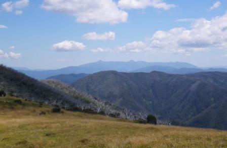
Turning right here leads through alpine meadows, following the ridge track for about 500m (past the top of Staircase Spur - return route) to the rock cairn that marks the highest point in Victoria. There is no single best vantage point here so it is a good idea to wander around the summit area and get a few good viewpoints. On a clear day there are many excellent views of the surrounding high country, and the river valleys below.
When the pylons for the Dartmouth hydro-electric power station were being installed (in the early 1980s) there was concern about the visual impact of power pylons in pristine bushland (particularly from the top of Mount Bogong), as well as the initial impact of huge swathes of land being cleared to facilitate vehicular access for cable laying.
The visual impact of the power pylons was minimised by their careful placement, and by painting them green. Getting the cables installed was far more ingenious. Instead of clearing land between all of the pylons to lay the cables (normal practice), model aircraft were employed in many locations to fly very fine fibres between some pylons; these were then used to drag progressively larger fibres across the void, followed by ropes and then stronger ropes. Eventually, the ropes were used to pull the power cables into position.
If you are on a day trip, walk back towards Eskdale Spur, and veer left down the Staircase Spur. This leads past the site of the derelict Summit Hut, and a memorial cairn to a party of skiers (Georgine Gadsden, John McCrae and Edward Welch) who died near here in August 1943. The trio were trying to reach Cleve Cole Hut (see below) in blizzard conditions, and were found several days later; the memorial obelisk was erected in 1945.
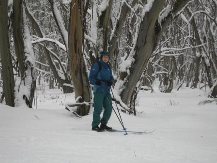
The Bogong area is still quite a popular cross-country ski venue, but the initial steep (pedestrian) access keeps numbers to a minimum.
Soon after the memorial, the tree line is reached, and then the Bivouac Hut ruins, and its nearby replacement.
The descent continues, steep in places, finally reaching familiar territory at Mountain Creek. Turn left here, and walk the final two kilometres back to the start.
Vehicular access to Camp Creek Gap
Driving direct to Camp Creek Gap will save a few kilometres of walking, as well as several hundred metres of elevation gain, and this is quite a popular optional starting point for the Mount Bogong area, particularly for those who are carrying all of their camping gear.
Continuing on by vehicle from the Mountain Creek area, take the signposted track to Mitta Mitta. This is Trappers Gap Road, but is also known as the Summer Road, and meanders around the hillsides for about seven kilometres, with amazing views of the Mount Bogong massif to the right. This short run leads to an open area where several roads/tracks meet up, with Trappers Gap Track (also known as Camp Creek Gap Track) being to the right (the signage at this intersection says ’4wd only’, however in dry conditions any well maintained vehicle should have no problems with this route).
Trappers Gap Track/Camp Creek Gap Track leads to a sweeping bend cum t-junction, where a side track (to the right) leads to a small cleared area with parking space for about 20 vehicles. From here, take the signposted Eskdale Spur Track as previously described.
Cleve Cole Hut [AWTGS-5]
If you have more time (that is, you are camping on the mountain) you may want to follow the snow poles down the ridge, past Hells Gap, and then south-east to the Cleve Cole Memorial Hut (about four kilometres in total) - taking care to return via the same route - see the recommended map for more details.
The Cleve Cole Hut commemorates the work of a pioneer skier of the high country who died in August 1936. Cleve Cole, and other members of his party, were caught out in bad weather on the southern slopes of Mount Bogong, and eventually had to be rescued by another party, after having endured several days of appalling alpine conditions.
Cleve was taken to the Omeo Hospital but died there, having been treated for all of the effects of frostbite and hypothermia.
The Memorial Hut was erected by volunteer labour during the summer of 1937-1938, and is still maintained by local volunteers. The Hut was given a Victorian Heritage Listing in 1988, and is recognised as being is one of the most substantial of the high country huts (it is constructed of local stone).
See Harry Stephenson’s masterpiece Ski-ing the High Plains for more details of both of the tragedies mentioned. Janis Lloyd’s Ski-ing into History also covers these events. Both books have been out of print for a long time, but many libraries still have a treasured copy of both titles.
Cleve Cole Hut is a good place to make camp for the night (a reasonable amount of shelter) and if this is your chosen site it is worthwhile taking the short trip to Howmans Falls about 1.5km away. The Falls can be reached by following the Alpine Walking Track east for about a kilometre, and then turning right (south) at Camp Creek. Return home via the reverse route, and the Staircase Spur.
COPYRIGHT © 1995-2020, Chris McLaughlin.