MOUNT BEAUTY WALKS
(www.northeastvictoria.online)
Tawonga Gap Ridge
This ridge walk leads north from the scenic Tawonga Gap, and is a ‘there-and-back’ route, or a 15km one-way route.
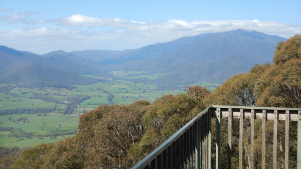
The action starts by taking the Tawonga Gap Road to the Lookout, where there is a large roadside reserve, and a plaque that commemorates the opening of this road in 1896.
If you have the choice, this starting point is best approached from Bright; coming from Mount Beauty, great care is required as you need to cross to the ’wrong’ side of the road, and visibility is restricted by sharp bends.
The short version of this walk is rated as AWTGS-2, the longer at AWTGS-3. In either case, the walk requires a formal set of walking shoes, as well as a copy of the Spatial Vision Map Bogong Alpine Area.
If you are tackling the 15km route, then you need to position a vehicle at the finish, at German Creek Track. This is a signposted turning off the bitumen, about four kilometres towards Bright from Tawonga Gap. There is plenty of car parking space here, well clear of the bitumen.
Starting out from the car parking area at the Gap, the pathway is quite wide, following a little used vehicular track to the north. This leads to an undulating ridge system, with lots of tall timber, and the occassional valley view.
The turn-around point for the short version can be anywhere along the ridge, but many walkers step it out to the first track junction (Running Creek Track) about six kilometres away. This gives a 12km outing, taking about four hours to complete.
However, for the 15km people, continue on from here for a short distance, to where German Creek Track heads off to the south. This track also follows a ridge system, but then begins a descent down to the said Creek.
The waterway here is about two metres wide, but is normally quite shallow, making for an easy crossing.
Climbing up the track from the Creek provides nice skyline views (hopefully blue ones), and not long before the bitumen, there are some intriguing glimpses of the high points of the Mount Buffalo Plateau, off to the right.
COPYRIGHT © 1995-2020, Chris McLaughlin.