MOUNT BEAUTY WALKS
(www.northeastvictoria.online)
Moncrieff’s Track
This 16km route leads from near the Mountain Creek Picnic/Camping Area, at the base of the Mount Bogong Staircase Walk, to the East Kiewa River, just out of Mount Beauty, or vice versa.
The walk is rated as AWTGS-3, with formal walking shoes/boots, a set of trekking poles, and the Spatial Vision Map Bogong Alpine Area being essential.
As this is a ‘one-way’ walk, a car shuttle is required, taking about 25 minutes in each direction.
Alternatively, if you are part of a larger group, it is feasible to have two groups of walkers starting from both ends of the walk, with a commitment to swap car keys at the mid-point.
Another option is to complete a ‘there-and-back’ walk to Moncrieffs Gap (935m) from either of the starting points.
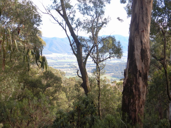
As predicted from a look at the map, this is a valley perimeter walk, and the winding track follows a terrace system that overlooks the floodplain of the beautiful Kiewa River.
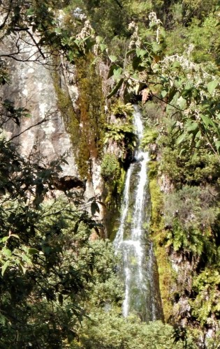
One of the highlights of the walk is a scenic alpine waterfall. This is about 3.8km from the Mountain Creek end of the walk, and is at GPS reading 36.43.130 : 147.15.094.
There are many great views to enjoy, and no shortage of places to have morning tea, and lunch.
In either direction, the overall time spent on this undulating walk will have been about six hours.
Mount Beauty From Mount Beauty, the adventure starts from Rock Pool Road, with access by taking Damms Road from the northern side of the township, and then swinging right onto Rockpool Road.
Starting out from the car parking area at the end of Rock Pool Road, the first objective is to cross over the East Kiewa River. There is no bridge here, just a vehicular ford (that you need to cross), and you may choose to have a spare pair of socks in your backpack.
If you have a reasonably high ground clearance 4wd, it is possible to cross the river, and park on the left side of the track. However, there is only enough room for two vehicles on the other side.
Once over the river, take Moncrieff’s Gap Track, ignoring the track going off to the right.
After a steep descent, the track finishes at a t-junction on the main access roadway for the Mount Bogong Walk, and you need to swing right at this point to get to the Mountain Creek picnic area, about 100m away.
Mountain Creek From the other end of the walk, the adventure starts at the local gateway to the Alpine National Park, close to the Mountain Creek Picnic/Camping Area. Access is from Mountain Creek Lane, which leads off the Kiewa Valley Highway, adjacent to the former Bogong View Hotel in Tawonga South.
As you approach the picnic area, Moncrieff’s Track goes off to the right. There is a small amount of car parking at the entrance to the track, but you might find it better to park at the picnic area, and walk the 100m to the start of the walk.
There are some steep pinches in the early part of the walk, but after that, undulations are the order of the day.
Alternative start/finish point An alternative start point for this walk is to take Survey Track (from near the Golf Course) and then swing left, down to the East Kiewa River, and follow this beautiful stream downstream to Rock Pool Road.
The alternative finish point for this walk is, having crossed the East Kiewa River, swing left onto the East Kiewa River Track, and follow this through to Survey Track, and then the environs of the Golf Club, and then the town centre.
Both of these options add about three kilometres (60 minutes) to the walk.
See the Survey Track, and East Kiewa Rock Pool walk descriptions for more details.
COPYRIGHT © 1995-2023, Chris McLaughlin.