MOUNT BUFFALO NATIONAL PARK
(www.northeastvictoria.online)
Mount Buffalo was first documented by explorers Hamilton Hume and William Hovell in 1824 (see Biographies on the Homepage) and is a prominent landmark from the Ovens, Buckland and Buffalo River valleys. The massif rises abruptly from the surrounding countryside, and is visible from many different angles.
Rooftop Maps, Mount Buffalo Adventure Map provides nice coverage of the Park, as does Spatial Vision’s Mount Buffalo. The VicMap 1:50 000 map sheets are Bright and Buffalo, available in print, and GPS (digital), format. The Parks Victoria website (see below) also has some handy PDF files for the Park.
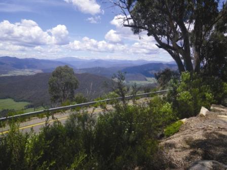
The drive from Porepunkah through to The Horn takes about 50 minutes, assuming that there are no stops on the way. However, there are many items of interest before getting to The Horn, and the drive makes an excellent day trip.
History
Local aboriginal people were the first to visit what is now the Mount Buffalo National Park, and they came to the Plateau each summer to feast on the Bogong Moth. This small, migratory, insect provides a rich source of protein, and was a key part of the diet of the aboriginal hunter-gatherer lifestyle.
Major Mitchell (see Biographies on the Homepage) also passed this way, and once back in Sydney, gave glowing reports of the area.
This paved the way for european settlement, and in the early 1840s, Thomas Buckland arrived in the area, taking up the Junction Run, at the confluence of two significant rivers at what became known as Porepunkah (these streams would soon be known as the Ovens and Buckland Rivers).
In order to facilitate high country grazing, the Buckland family cut a track through to the Mount Buffalo Plateau from the valley floor. This became known as Goldies Track (after the station manager) and remained in use until the mid-1950s, when alpine grazing was finally halted.
Goldies Spur Track still exists; being a turn to the west at Buckland Bridge, but no longer continues all the way to the Plateau.
As well as pastoral interests, gold soon became a hot topic of conversation, and at the height of the Buckland Valley Gold Rush, there were over 5 000 mining hopefuls along the river flats of the Buckland.
Amongst the mining fraternity, there were two brothers, James and John Manfield, and this pair, along with Bill Weston and Ted Carlile, became the first to open up the Plateau to tourism.
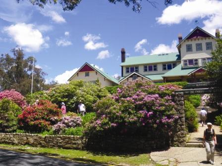
Weston and Carlisle built some small hostels at several points on the Plateau, but it was left to the Manfield’s to build Manfields Chalet at Bents Lookout, close to the present day Mount Buffalo Chalet.
The volume of tourist traffic now provided the impetus for a more direct route to the Plateau, and in the late 1880s a new route was cut through the north-eastern slopes; it was named Stakers Track (after William Staker) and was largely funded by the Weston Family.
The current alpine style route was cut through in 1908, and largely follows the route selected by Staker.
Late in the 19th Century, steps were being taken to establish Mount Buffalo as the first National Park in Victoria, and the first tranche of land was reserved as such in 1898. In conjunction with this, there was a hive of construction activity on the Plateau, including the previously mentioned Manfields Chalet.
As expected, the National Park is busy during peak periods, and in years gone by accommodation varied from camping at Lake Catani, and guest house style accommodation at the Mount Buffalo Chalet. The Chalet was a great place to stay, with plenty of ambience and spectacular surroundings; unfortunately it has been closed for a number of years, but may reopen before too long.
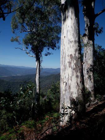
The present day Park is much bigger than the original 1200 hectares, and covers about 31000 hectares of beautiful alpine scenery. The Park’s main attractions include excellent scenery, expansive views, many different vegetation communities (including a well-known wildflower display in spring) and a comprehensive network of walking tracks.
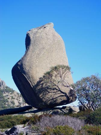
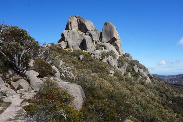
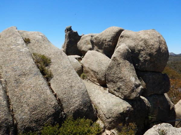
The distinctive topography of the Plateau itself includes many outcrops of granite with weird shapes and weird names; Og Gog and Magog, Monolith, Torpedo, Stonehenge, Wall of China, Cathedral, Tables and Loaves, The Castle, Pulpit Rock and Devils Peephole are a few examples.
Many of the plant species found in the National Park are well adapted to a sub-alpine environment.
The climate of the Plateau is characterised by cold winters and mild summers. There are snowgum woodland areas, heathlands, grasslands with wildflowers, herbs and snow grasses, and boggy areas with water-tolerant sphagnum moss, sedges and grasses.
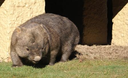
Despite the cold winters, a wide variety of native mammals and birds live on Mount Buffalo. Those most likely to be seen in the warmer months include wombats, possums, honeyeaters, robins, lyrebirds and crimson rosellas.
See the Mount Buffalo Chalet website (link below) for the latest information on the Chalet.
Access
Porepunkah is the gateway to Mount Buffalo, with the road to the Park going off to the south from the roundabout near the Ovens River in Porepunkah. Although twisty, the access road is sealed all the way to Mount Buffalo Chalet, and assuming that you stop off at least once to admire a waterfall or tumbling creek, can take up about two hours of travelling time.
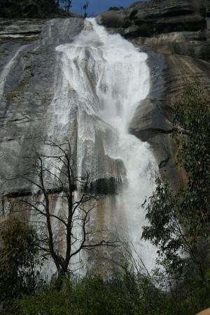
Predictably, the drive to the Plateau is very enjoyable with many pleasing views of landscape, waterfalls and vegetation. On the way up stop at Eurobin Falls (on the left, about two kilometres from the park entrance) and enjoy the short loop to these beautiful fern-shrouded falls.
There is a car parking area on the left, just before the road crosses Eurobin Creek, but the car park for the walking track is a little further up hill.
The first falls encountered are Ladies Bath Falls, and from here the track continues on to the main waterfall (Eurobin Falls). Walking time is about 45 minutes, and the distance covered 1.5km.
Continue on for about six kilometres, and the next attraction is Rollasons Falls, about 8.5km from the park entrance; see the description later on in this document.
Mackeys Lookout is the next attraction, about 11km from the entrance. This location offers good views over the access road, as well as the now distant Buckland/Ovens Valley.
The road now levels out, and a fork to the left leads to the Chalet (two kilometres) and to the right to Lake Catani (2.5km), and thence Dingo Dell, Cresta and The Horn.
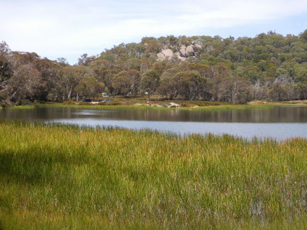
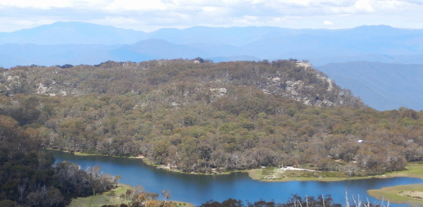
Lake Catani
Lake Catani is a small, but very picturesque, lake in the heart of the National Park, and offers excellent camping in an alpine environment. The Lake is easily accessible during spring, summer and autumn, with winter access being subject to snow cover. Good amenities are provided throughout the camping area, but campers are advised to bring their own drinking water.
The camping area makes a convenient base from which to explore the Park, with the Chalet area being about two kilometres away, and Chalwell Galleries being a mere 750m. Other areas of interest usually require a short drive. Bookings are usually required in peak periods; most sites can be booked, however some are available on a first-come first-served basis. None of the sites are powered, and only a few sites can accommodate camper-trailers and caravans (the small variety).
The Parks Victoria website (see below) has a handy PDF download, with a site map and further information on camping at the Lake.
Walks and other activities
Gorge Nature Walk [AWTGS-2]
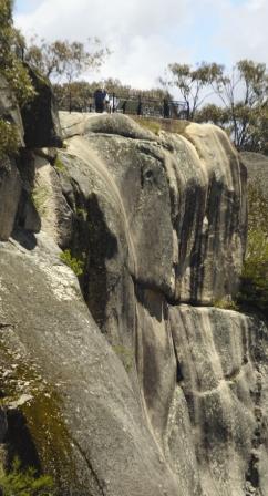
This is a two kilometre adventure, taking a little over an hour to complete, starting at the footbridge over Crystal Brook. The walk is signposted from the car park (near the Chalet) and covers an anti-clockwise loop, including side trips to Pulpit Rock, superb views of the Buffalo (Crystal Brook) Gorge, and Wilkinsons Lookout (more excellent views).
Gorge Views [AWTGS-2]
This excellent, and popular, walk starts from the Gorge Lookout. Follow the track (signposted Gorge Nature Walk) passing several lookouts on the way to Pulpit Rock. There are excellent views of the Buffalo (Crystal Brook) Gorge, Crystal Brook Falls and the Ovens Valley. Walking time is about 30 minutes and the distance covered 1.5km, however this can be extended by continuing on to Wilkinsons, Reeds and Manfields Lookouts (allow another two hours, AWTGS-3).
Monolith Track [AWTGS-3]
The start of this walk is opposite the Parks Victoria maintenance garage on the Horn Road, or the nearby National Park Information Centre. The Monolith (1400m) is a large granite tor which provides views of nearby Lake Catani and, in the opposite direction, Hospice Plain.

Walking time is about one hour, and the distance covered is about 2.5km.
Leaving the Horn Road, the track meanders around to a sign-posted junction, where the Monolith is to the right.
Great care is required within the environs of the Monolith itself, as there are many tricky nuances underfoot, and many unprotected abrupt drops.
A plaque on the rock commemorates the first ascent of this monster by Edward Carlisle, way back in 1893.
The Monolith is also accessible from the main carpark near The Chalet; take the Gorge - Lake Catani Track and swing right after about 250m, taking the signposted track to The Monolith, which is about 1.2km away at this junction.

The Monolith Track can also be used to access The Chalet from The Horn Road.
In this case, continue on from The Monolith turn-off, and follow this very scenic walking track through to the junction mentioned above.
Turn left here for an easy 250m ramble through to The Gorge, and The Chalet itself. Total distance for this option is about 2.5km.
View Point Nature Walk [AWTGS-3]
This enjoyable walk begins near the Lake Catani dam wall, and is a four kilometre return loop. Depending on how much time you spend looking at the different items of interest, it can take up to two hours. Start by following the track signposted towards the Chalet for about 600m, and then turn right just before the bridge over Eurobin Creek; continue through the forest, and over rocky terrain, to the View Point Lookout.
Return via the same route, or take the Underground River route to the Chalet, and then back to the Lake (allow an extra hour). Alternatively, the start and finish of this walk can be at the Chalet.
Lake Catani - Lakeside Walk [AWTGS-2]
This is an excellent walk through open forest to the northern shoreline of the small, but picturesque, Lake Catani. The walk starts from the eastern end of the Chalet (the left when facing the building) by taking the signposted track Gorge and and Lake Catani.
Eurobin Creek is crossed just before the lake is reached, and then the dam wall.
The track now continues around the eastern lakeshore to the camping/picnic area, where you need to make a u-turn. Walking time is about two hours, and the total distance covered is about six kilometres.
As an optional extra (AWTGS-3), circle the lake; this takes an additional hour, and involves continuing past the camping area, and then taking the slip track off to the right. This follows the lake shore for a while, but ultimately dumps you on the side of the bitumen.
Proceeding carefully, cling to the road shoulder, and follow this through to Grossmans Picnic Area, and then a further 100m to the vaguely signposted track (off, and down, to the right) that is the continuation of the Lakeside Walk.
This leads, via a very scenic pathway, back to the dam wall of Lake Catani.
Once back on the main track, hang a left for the return route to the start, and the completion of an eight kilometre (three hour) loop.
Billsons Lookout and View Point [AWTGS-2]
An alternative route is to start by visiting Billsons Lookout and/or View Point, and then take Lake Walk. Billsons Lookout is a left turn about 500m from the signpost mentioned in the previous section, and offers more spectacular views over the surrounding High Country.
View Point can be reached by taking the signposted access track leading off to the left (east) just after crossing Eurobin Creek, and is about two kilometres away at this point. Keep right at the t-junction, and prepare for a sustained climb.
View Point is also accessible from the Lake Catani camping/picnic area. In this case, take the track that lead downstream (that is, towards the dam wall) and then veer right just before the bridge over Eurobin Creek.
Chalwell Galleries [AWTGS-2]
Another pleasant extension from Lake Catani is to Chalwell Galleries, south-east of the lake.
From the camping ground, follow the signposted walking track through snowgums, and up to the edge of the Galleries which comprise of an interesting collection of disorganised granite slabs.
At the Galleries, there are excellent views of the Buckland Valley and Porepunkah.
Returning by the same route, the walking time is about one hour, and the distance covered is about two kilometres.
Only continue through the maze of boulders that constitute The Galleries if you are confident of your agility; in this case, add another two kilometres to the route (AWTGS-3).
Dicksons Falls Nature Walk [AWTGS-2]
The short walk to Dicksons Falls (one of many scenic waterfalls around Mount Buffalo) starts near the Tatra Inn site (on the east side of the road) and the many items of interest along the way to the falls are detailed in the brochure produced by the National Parks office. Walking time is about one hour and the distance covered four kilometres.
The Castle and The Sentinel [AWTGS-2]
This is a mostly uphill walk that takes in some of the more unusual rocky features of the Park. The action starts by pulling off the road at the sign-posted car parking area (this is between Dingo Dell and Cresta, on a noticeable saddle).
From here, the track leads up to some great views of the surrounding range, as well as The Castle and The Sentinel. Overall walking time is about 45 minutes.
The Cathedral and The Hump [AWTGS-2]
As with the previously described walk, this is a mostly uphill adventure, and takes in some more of the unusual rocky features of the Park.
As above, the action starts by pulling off the road at the sign-posted car parking area (this is between Dingo Dell and Cresta, on a noticeable saddle).
From here, the track leads up to The Cathedral, and then The Hump. Overall walking time is about 90 minutes, and the distance covered is about two kilometres.
Mount Dunn Loop
This is a 15km loop of about AWTGS-4 standard, with the main items of interest (as well as the excellent scenery) being Mount Dunn, The Woolpack, The Devils Couch, The Giants Causeway, Stanley Rocks and Drillhole Rocks.
The walk starts by taking Long Plain Track, which can be found at the south-western corner of Lake Catani; there isn't much room for parking at the trailhead, and you might need to park near the Grossmans Mill picnic area (on the western shore of Lake Catani).
In this latter case, you will need to carefully walk a short distance alongside the bitumen.
Long Plain Track follows Eurobin Creek for about 1.5km, to a y-junction, where you need to veer right for another kilometre which will take you to the sign-posted Mount Dunn turn-off (to the left).
The views from Mount Dunn are exceptional, and to get to the top involves tackling a few metal stairways - take care!
Returning to the main track, turn left, and then veer left at the next intersection (a mere 500m away. This leads around to the base of the Woolpack (an interesting rock formation) where you need to make another left turn.
From here it is about another for about 800m to another track junction, also involving a left turn; en-route in this 800m section, the Devils Couch will be visible to the right.
Follow the signposts to the Giants Causeway (and Macs Point) but swing left after 500m to get to the Causeway (Macs Point is an optional two kilometre detour - see recommended map for details).
Having passed through the area of the Giants Causeway, turn right at a t-junction, and follow this two kilometre section of track through to another t-junction. This leads past Stanley Rocks and Drillhole Rocks, where the effects of water erosion, and chemical attack, on granites can be seen.
Turn left at the t-junction mentioned above, and follow this through to a y-junction, where Long Plain Track is off to the right.
All that remains to be done, is to follow this track through to the bitumen, and thence (if necessary) turn left for Grossmans Mill.
Allow at least five hours for this adventure, and take plenty of water, some morning tea, and a lunch with you.
The recommended map is Spatial Vision’s Mount Buffalo National Park, and this will need to be an essential part of your gear, as well as formal walking shoes/boots and a set of trekking poles.
Og, Gog and Magog [AWTGS-3]
These weird and wonderful granitic rock formations were named after similarly weird limestone formations to the south of Cambridge, England, and provide a very enjoyable day walk of about 8km, AWTGS-3.
The usual access point to start this adventure is the Reservoir Picnic Area, the turn-off to this being about 700m past the turn-off to the Chalet.
The Reservoir access road weaves around for about 3.5km, terminating at a small picnic area, where there is a limited amount of car parking space.
The walk commences by back-tracking a few hundred metres, to where the Mount McLeod Track goes off to the left (you will have passed by this junction on the way in to the picnic area).
A short distance from the start, there is a sign-posted turn to the left that leads to Og, Gog and Magog. This pleasing track meanders around the woodlands, and grasslands (avoiding the high ground) for about 1.5km before arriving at a minor t-junction.
Keep left here, and within a short distance you will have Jessies Lookout on the right, and Og etc on the left.
Getting to the heart of Og, Magog takes great care (steep, messy terrain) and is best taken at a slow pace.
Returning to the track, you need to keep left, and follow this through to another t-junction, where Eagle Point is to the right.
This is an interesting two kilometre detour (one kilometre to get there, one to get back) with many interesting rock formations to admire on the way. Add at least an hour to the estimated walking time if you want to tackle this detour.
The return to the picnic area involves turning left at the t-junction mentioned above, and meandering through to Rocky Creek Track, where yet another left turn is required.
This now leads (after a short distance) to another intersection, where expectedly you keep left (that is, stay on Rocky Creek Track) and follow this through to the picnic area (ignore Long Plain Track off to the right).
In this last section, a feature known as the Devils Couch will be to the left, and this makes a short detour of about 400m, all up. Like Og etc this also requires a slow careful walk.
The recommended map is Spatial Vision’s Mount Buffalo National Park, and this will need to be an essential part of your gear, as well as formal walking shoes/boots and a set of trekking poles.
The Back Wall [AWTGS-3]
This is one of the longer walks on the Plateau, and starts by following the Dicksons Falls track (see previous description) from the road near the Tatra Inn site (Horn Road) until the signposted track to the Back Wall is reached. There are a few boardwalks in this area, where the track passes over a number of wet areas amongst alpine grasslands.
Views on the way include some of the best vistas of The Horn, as well as a great mix of alpine meadows and jumbled granitic boulders.
Entertainment on the way includes Tables and Loaves and Stonehenge. At the Back Wall there are expansive views of the High Country, and the Buffalo/Rose River Valleys. Walking time is about four hours and the distance covered 12km.
The Cathedral and the Hump [AWTGS-2]
Step this one out from the Cathedral picnic area by following the signposted track up to the Cathedral. A longer track off to the left leads to The Hump and from here there are superb views of the Horn (the highest point of the Plateau, 1720m), Tatra Inn and extensive areas of snowgum woodland. Walking time is about one hour, and the distance covered two kilometres.
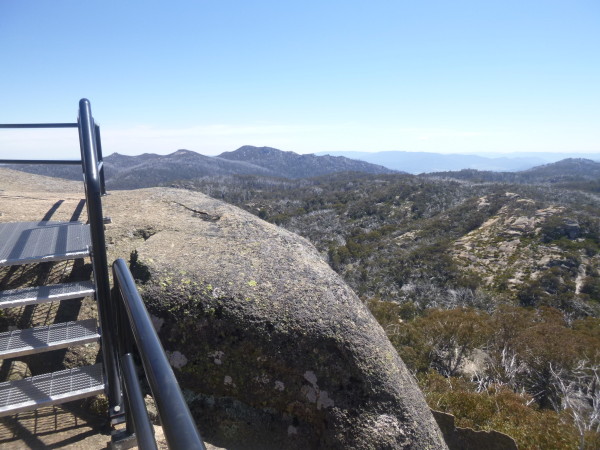
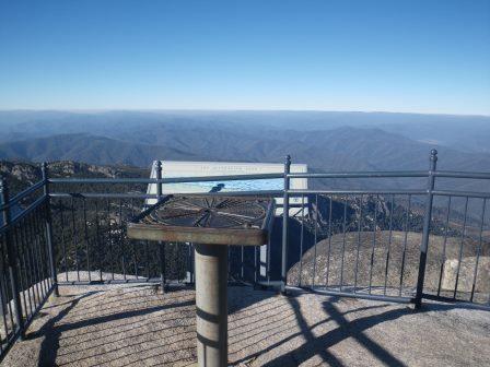
The Horn
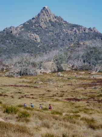
Getting to the Horn involves a bit more effort than some of the other walks described, and the leg stretching begins at the Horn car park. The Horn is the highest peak of the park (1720m) and offers extensive views of the High Country. Walking time is about 45 minutes, and the distance covered 1.5km. The last few kilometres of the access road are unsealed, but despite this The Horn is one of the most popular venues of the Park, and an early start is always a good idea.
South Buffalo Viewpoint [AWTGS-3]
For some reason this walk is not as popular as many other on the Plateau; however, it makes a very enjoyable three hour adventure of about eight kilometres, and starts off from the Cresta car parking area.
Following the sign-posted access point (just around the corner from the car park, a few metres towards The Horn), the track leads out to the first of several saddles, and the first of several excellent views.
Continuing on, the walk alternates between alpine grasslands, alpine bogs and more saddles, with nice views of the not too distant Horn to be enjoyed.
Towards the southern end of the walk, the footpad splits, with the left fork leading to the official lookout point. From here there are nice views of the Rose and Buffalo Valleys, as well as Lake Buffalo.
After refreshments, you need to retrace your steps back to the car park. The other branch of the track (referred to above) can also be investigated on the way back. This leads to a large outcrop of granite, with similar views to that of the main lookout.
Lake View [AWTGS-2]
Lake View provides great views of Lake Catani, as well as much of the plateau, with initial access being via The Horn Road, just past the Parks Victoria information centre.
There is plenty of parking at the start of the track (on the right-hand side of the bitumen when heading towards Lake Catani, and The Horn), and from here, the track begins an alpine style ascent to the lookout.
Distance covered is about 1.8km each way, and it is very pleasureable to allow plenty of time at the peak so as to admire the views; Mount Bogong is clearly visible, as is Mount Feathertop, as well as an endless array of blue tinged range country.
Rollasons Falls [AWTGS-2]
This is a popular four kilometre, there-and-back walk, leading to one of the plateau's many scenic waterfalls.
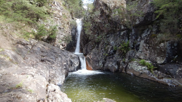
Initial access is via a roadside parking area, about 8.4km from the park entrance; this is on the righthand side of the bitumen when heading in to the Park, so great care is required when pulling over to the parking area when travelling uphill.
Once safely parked, there are picnic facilities, and toilet amenities, within easy reach, as well as a storyboard that outlines the walk.
Setting off, the initial part of the trail is quite easy, but then begins an alpine style descent down towards Buffalo Creek.
A t-junction is then encountered, with the Upper Falls being to the left, the Lower Falls to the right. Take care on the final descent to the water, as there are several steeply stepped rocks to navigate.
In either case, it takes about 45 minutes to reach Buffalo Creek, and the return route is by retracing your steps back to the picnic area.
If you just want to visit one of the two options, then the Lower Falls are probably the best choice; this takes about 500m from the outing.
When the tough get going . . .
This is The Big Walk that links the Park entrance gate and the Chalet. Whilst it can be walked in either direction, many have a preference for the downhill option, as this saves energy for admiring the scenery.
In either direction, before setting off, organise someone to collect you at the entrance gate/Chalet, or be prepared to hitch a ride back to the start.
The 11km descent (AWTGS-4) takes four to five hours, and starts from the Chalet car park, or the Oval Picnic Area. Take the sign-posted track to Manfields Lookout/The Big Walk, and then cross Crystal Brook after a short distance. Without actually calling at the Lookout, continue in a generally north-west direction, and then descend to the gully, past the turn-off to Reeds Lookout.
This is where the track starts its plunge over the contour lines, descending steeply past Marriotts Lookout, and then via an undulating section to Mackeys Lookout, and the Park access road.
The track now follows the access road quite closely for a short distance, gradually losing altitude, before dropping off to the right to pick up Seven Mile Point, and the access road once more. Cross over the bitumen (take care!) picking up Wilhelmina Spur Track, and then the signposted track off to the south-east (right).
This track leads to a couple of small creek crossings, and finally to Eurobin Creek (where there is a pedestrian bridge) before reaching the Park entrance gate, and an expansive parking area.
If you are completing the walk in the uphill mode, then there is about 11km in the horizontal awaiting you, as well as about 1000m in the vertical.
In either case, the Big Walk is very well sign-posted, and is a popular walk, particularly on long weekends. For more detail, see the Parks Victoria website (link below) which has a detailed description (PDF, with map) of the Walk.
Intro Screen on a fresh browser page
COPYRIGHT © 1995-2024, Chris McLaughlin.