
MOUNT GRANYA STATE PARK
(www.northeastvictoria.online)
Mount Granya State Park is located about 60km east of Albury-Wodonga (20km north-east of Tallangatta). Like Mount Lawson State Park, Granya is noted for its steep slopes, cliffs and prominent rocky bluffs, and a diverse range of plant communities. The higher sections of the Park have open forests of narrow-leaf, and broad-leaf, peppermint, whilst the north facing (warmer and drier) slopes have small areas of black cypress-pine. Springtime wildflower displays add a seasonal dash of colour to all of this greenery.
Rooftop Maps, Upper Murray Adventure Map provides nice coverage of the Park, and the VicMap 1:50 000 sheet is Granya, available in print, and GPS (digital), format. The Parks Victoria website (see below) also has some handy PDF files for the Park.
Access to the Park from the Murray Valley Highway (B400) is by turning north at Bullioh, taking the Granya Road (the C546, also known as Murray River Road) and then turn left onto the Mount Granya Road. The C546 is very scenic, with great views of floodplain landscape to the right, and leads to Mount Granya Road after about 7.5km from the B400.
Mount Granya Road is a left turn, and leads for about 7.5km (on gravel) to the summit of Mount Granya (870m) and some great views. There is only a small amount of room to manoeuvre on the access road to the summit, and at the car park, so this is not a good place to take a large vehicle (such as a motorhome) nor a caravan.
There are picnic facilities at the car park, as well as a toilet block, making this a popular picnic destination for visitors and locals alike.
Georges Creek Lookout is a short stroll from the car park, with a short walk on the nearby Lyrebird Walk also being an enjoyable option (AWTGS-2).
For the more energetic, there is a five kilometre walking track (AWTGS-3) to the Cottontree Picnic Area (see below).
Return to Granya Road, turn left (north) and then take Webbs Lane at the small settlement of Granya, for the Cottontree picnic and camping area, a total of about eight kilometres from the Mount Granya Road (16km from the summit). There are several good views of Lake Hume as you approach Granya (a former mining township), so this is a very scenic drive.
The Cottontree Creek picnic area provides access to another short walk, this time to the picturesque and rocky Granya Falls (AWTGS-3), with a continuation (for the energetic) to Mount Granya (about six kilometres away, AWTGS-3) via Jurgies/Georges Walking Track. There is an initial steep section on this walk, followed by a flat-ish section, then a final stiff climb to Mount Granya, making this quite a hard walk.
The camping area at Cottontree is quite spacious, and has plenty of shade, making this a popular venue in holiday periods.
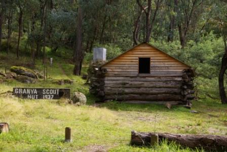
The Falls are at their best after substantial rainfall, and are of more interest for their rocky setting, than for the spectacle of cascading white water. Heading off from the car park area, the Falls are signposted off to the right, and are an easy stroll away. The Granya Scout Hut is encountered before the Falls (about 400m from the car park), with the Falls being about 700m away.
Returning to the C546 (and the bitumen), you can make a right turn to take you back to the Murray Valley Highway, or a left turn to get to the north-eastern section of Lake Hume. Assuming that you take a right turn, this will have been an interesting loop of about 50km from the Highway.
Intro Screen on a fresh browser page
COPYRIGHT © 1995-2020, Chris McLaughlin.