MOUNT LAWSON STATE PARK
(www.northeastvictoria.online)
Mount Lawson State Park is located about 70km east of Albury-Wodonga, and can be accessed via the C542 from the north, or the B400 (Murray Valley Highway) from the south. The southern approach is the most popular, as this gives easy access to the Koetong Creek campsite, and the summit of Mount Lawson. Whilst the Murray River forms the northern boundary of the Park, artificial structures define the southern boundary (the Murray Valley Highway, and the now disused Wodonga - Cudgewa Railway).
Rooftop Maps Upper Murray Adventure Map provides nice coverage of the Park, and the VicMap 1:50 000 sheet is Granya; available in print, and GPS (digital), format. The Parks Victoria website (see below) also has some handy PDF files for the Park.
The Park is well-known for its steep slopes, cliffs and prominent rocky bluffs and a diverse range of plant communities. The higher slopes of the area have open forests of narrow-leaf peppermint, candlebark, mannagum, bluegum and brittlegum, whilst red stringybark and long-leaf box are found at lower elevations. The north facing (that is, hotter and drier) slopes also have large areas of black cypress-pine and kurrajong woodlands. The springtime wildflower displays are not to be missed.
Prior to European settlement, the Yiamathong People made good use of this area (and similar nearby areas) not only as hunter-gatherers, but as residents of some of the rock shelters and overhangs. Access is achieved by taking the Murray Valley Highway east from Tallangatta, and swinging north onto the Mount Lawson Road (about 32km from town). This turn-off also leads to a picnic area alongside a historic railway trestle bridge (part of the now dismantled Wodonga - Cudgewa Railway) and shortly after this Firebrace Track (a left turn) leads towards the Conic Range. This offers a short (1.5km, 90 minute all-up) walk up to a local peak, with spectacular views over the Koetong Creek Valley.
Firebrace Track has a good gravel surface, and except in wet conditions is passable by most vehicles (not those towing a trailer). It is about 4.5km to the small pull-in that serves as a car park for this walk, and from here the direction to take is clearly indicated with red triangles leading the way. The accurate signage at the car park says that this is a 1.5km walk, and that it will take about 45 minutes to complete (that is, 45 minutes walking time all-up to get to Conic Rocks and back to the car park).
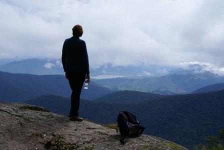
Expectedly, the terrain goes upwards, as well as onwards, and it is a pleasing climb through granite tor country, culminating in a spectacular view down to the rugged valley floor that Koetong Creek has carved out for its self. At this point there are many massive outcrops of pink granite (the conic rocks), and this is a very interesting place. There are also some great views of the north-eastern section of the not too distant Lake Hume.
As well as the great scenery, all of the typical weathering aspects of granite can be seen on the walk to the Rocks; chemical weathering from forest floor detritus, and the onion skin delamination that is characteristic of all forms of granite.
Back on the Mount Lawson Road, make a tight right turn onto the bitumen, and enjoy the 4.5km run to Koetong Creek Road. This is a left turn onto gravel, and provides access to some enjoyable, albeit small, camping areas alongside Koetong Creek. The campsites are numbered 1 and 2, with the second site being the better equipped of the twosome, and with nicer ambience. Both campsites have Koetong Creek frontage, and the sound of bubbling water is never too far away.
Returning to the bitumen, and continuing onwards, and upwards, Mount Lawson Road now leads to the summit area, seven kilometres away. At 1041m, Mount Lawson offers great views north over upper sections of Lake Hume, and the pastoral country beyond; to the south, there are great views of the high country. A well laid out picnic area provides a good excuse for lunch or morning tea, and the Summit Loop Nature Trail (1.5km, 45 minute all-up, AWTGS-2) serves up some moderate exercise as it meanders around the rocky outcrops just below the actual summit area. There are designated lookout areas on the Trail, and this is a very enjoyable walk.
The outward journey is now over, and all that is required is a nice careful descent to the Murray Valley Highway, completing a 40km loop (if you started out from Tallangatta, add 32km to get to the start of the loop, and another 32km to get back to town).
Intro Screen on a fresh browser page
COPYRIGHT © 1995-2020, Chris McLaughlin.