BIKE PATHS, RAIL TRAILS and CYCLE ROUTES
(www.northeastvictoria.online)
MURRAY TO THE MOUNTAINS RAIL TRAIL
The Murray to the Mountains Rail Trail currently runs from Wangaratta (altitude 149m) to Bright (altitude 304m), following the 83km path of the former railway that ran between the two towns. The Rail Trail was progressively developed starting from the early 1990s, and the present infrastructure was completed in 2002; it is now used by about 50 000 riders every year.
The missing link in the Trail (Bowser to Rutherglen) is expected to be completed over the next few years, and once this happens, the Trail will truly run from the Murray to the Mountains (the Rutherglen - Wahgunyah section is already open; see the previous menu for details). See also the Wangaratta to Rutherglen description on the same menu.
Since access points occur at regular intervals, there is no need to cycle the complete Trail, nor is it necessary to complete a loop.
There are several ’shuttle’ services operating out of Wangaratta, Myrtleford and Bright that will help position bikes for you, and/or come and get you from your chosen destination, and take you home. Your luggage can also be handled by the same companies.
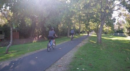
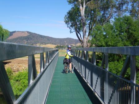
The Rail Trail surface is mostly gravel, set in bitumen, and provides a good ride in most places. There are many bridges to traverse, and the surface of these varies from steel, to timber to concrete to gravel; slow down for the timber ones, as their surface is not the best.
The Trail crosses the Great Alpine Road (GAR) on several occasions, and these crossings require great care, as traffic on the GAR may be travelling quite fast.
The easiest sections (in order of increasing energy required) are,
Bright to Myrtleford
Everton Station to Wangaratta
Wangaratta to Everton Station
Myrtleford to Bright
Everton Station to Myrtleford
Myrtleford to Everton Station
The best sections scenery wise (the most scenic is listed first) are,
Myrtleford to Bright
Bright to Myrtleford
Everton Station to Myrtleford
Myrtleford to Everton Station
Wangaratta to Everton Station
Weather watching should form a part of your trip planning, with hot weather and wet weather being times to avoid. Dehydration will be a major problem on days of 30+, and wet weather creates miserable cycling conditions. The cooler months of the year often provide ideal cycling conditions, with a nice sunny day in autumn or winter being hard to beat.
If there is a flood warning (of any kind) for the Ovens River at Wangaratta, then some of the early sections of the Trail will have water over them. Sections most affected by floodwaters are Apex Park (the start of the Trail), part of the section from Apex Park to the Vine Hotel, and the Hume Freeway underpass.
Mobile coverage along the Trail is almost 100%, with Telstra currently providing the best outcome. As well, there are several emergency phones en route, and these can be used if you have a major problem.
Many riders take a small repair kit with them, including a spare inner tube, and the necessary tools to fix simple problems. As well, take some nibbles in case you get peckish, and at least one litre of water per person.
Visitor Information Centres in the North-east have a brochure on the Rail Trail, and other cycling opportunities in the area, and this is well worth consulting prior to your wheels beginning to roll over the gravel.
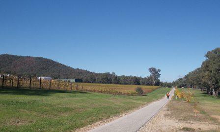
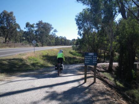
WANGARATTA to EVERTON STATION
This section of the Rail Trail runs from Wangaratta (149m) to Everton Station (236m) and is a 27km (90 minute) route, gaining about 87m end-to-end. The Trail officially starts at Apex Park, just over the Ovens River Bridge, which itself is just north of the CBD.
There is plenty of room for parking, and unloading here, as well as picnic amenities and a toilet block. Getting to Apex Park from the city centre either involves mixing with traffic in Murphy Street, and then taking the main Ovens River Bridge (which is quite narrow); or taking the slightly quieter Ovens Street, and then taking the Bickerton Street suspension bridge over the Ovens (the suspension bridge carries pedestrian and bike traffic only).
See below (after the main description) for details of how to get to the Rail Trail from the Wangaratta Railway Station.
Starting off from around Merriwa Park is slightly easier, as you can just follow the flood levee through to Chisholm Street, then swing into Faithfull Street, cross over the Mitchell Bridge (over the Ovens River) and then pick up the Rail Trail on the north side of the Bridge.
Starting off from Apex Park is, of course, easier than either the Railway Station or Merriwa Park.
From whichever starting point, once at Apex Park, the Trail leads off through an underpass of the Ovens River Bridge, and then swings left at the Ovens River / King River confluence, before getting up to speed along one of Wangaratta’s many flood levees.
The Trail then crosses the Great Alpine Road (GAR, take care) and heads north, basically following the old Hume Highway, and then the original Hume Highway, before emerging at the Vine Hotel. This is one of Wangaratta’s oldest pubs, and was a haunt of the Kelly Gang in the bushranger era. In the modern era it serves a great meal.
From the Vine, the official Trail veers left, and continues to follow the old Hume Highway northwards to Bowser Station (about seven kilometres north of town, 152m altitude). Bowser was originally known as Beechworth Junction, and was renamed in 1922, taking the name of one of the early settlers in the Wangaratta area.
Bowser was a major signalling station in the old days, but was dismantled when the Bright and Beechworth Railways were discontinued.
From Bowser the Rail Trail finally swings to the east, and you then need to negotiate a short (but dark) tunnel under the Hume Freeway. Once out in the daylight, you are on track for Everton, with a nice rest area at Reedy Creek, a little over two kilometres away, and about 11km from town.
[Not far from the Reedy Creek picnic area, you can make a detour to the gold mining town of Eldorado; see the separate description (Wangaratta to Eldorado) for more details; see also the description of Eldorado township on the HomePage.]
[An alternative route (that avoids the Freeway tunnel, and is slightly shorter than the official route) involves using some short sections of rural roads (take care!). This short detour involves swinging right at the Vine Hotel, and then left onto the Eldorado Road.
After crossing over (not under) the Freeway, you can then swing left to pick up the Byawatha Road; this then intersects the Rail Trail a few kilometres east of that dark tunnel. Turn right here (at Byawatha Road) and you are on track for Everton, with a nice rest area at Reedy Creek, a little over a kilometre away.]
Intermediate access-egress points are at Londrigan (161m, 13km), Tarrawingee (181m, 21km) and Everton Station (236m, 27km). Bowser, Tarrawingee and Everton Station all have good rest stops, with toilets provided. Everton Station is about 2.5km from Everton township, so with a short detour, you can also access the Everton General Store, Everton Gardens Caravan Park and the Everton Hotel.
EVERTON STATION to MYRTLEFORD
This section of the Rail Trail runs from Everton Station (236m) to Myrtleford (208m), and has several long slopes to tackle, with the 26km (120 minute) route dropping about 28m end-to-end. This data does not reveal the fact that there is the high point of Taylors Gap to negotiate on the way through.
Everton Station is about 2.5km from Everton township, so with a short detour, you can also access the Everton General Store, Everton Gardens Caravan Park and the Everton Hotel.
Intermediate access-egress points are Brookfield Station (181m, 5km; this is near a crossing of the GAR); Bowman (226m, 13km; this is the nearest access point to Bowman Station, the actual station site is on private property), Taylors Gap (320m, 15km), Gapsted Winery (233m, 19km) and Myrtleford (208m, 27km). Taylors Gap has a water supply, and Gapsted Winery is also a good place to stop off for some light refreshments; the actual site of Gapsted Station is on private property, and is not signposted.
Taylors Gap is a high point on the Trail, and has a steady climb when approaching from Everton, but a well earned descent on the other side. On the approach to Taylors Gap, you pass the Bowman Station site, and then enter some nice woodland before the final slopes.
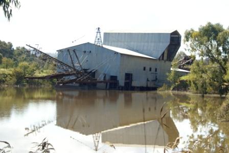
This area was once a hive of gold mining activity; evidence of this can be seen to the left and right of the Trail, where erosion damage created by sluicing activities is clearly visible.
Enjoy the nice descent on the east side of the Gap, but take care at the wooden bridges in this section; their surface is not the best. Once in Myrtleford, some riders take to the Great Alpine Road to get to the continuation of the Trail on the eastern side of town. However, the official route (see next paragraph) stays one or two blocks north of the GAR, and is much safer than the main road.
As you approach the urban area, there is a sharp curve around the Barwidgee Creek Bridge, and then the Rail Trail veers left to merge with a service road. Just prior to this, there is the option to continue straight-ahead, passing under the GAR, and taking a detour around much of Myrtleford’s urban area. See the end of this section for more details.
In the meantime, assuming you stay with the Rail Trail, follow the service road until you come to a t-junction at Prince Street (the Yackandandah Road) where you need to turn left, followed quickly by a right turn onto Smith Street.
There is a designated bike lane on Smith Street, but not on Prince Street. Just after you pass the Big Tree (on your left, hard to not see) there is a signposted left turn that picks up the formal Rail Trail route once more. This leads past the well-known (and well patronised) Myrtleford Bakery in Standish Street.
If you are staying overnight, Myrtleford has a good range of shops and services, as well as two caravan parks and several motels.
[As mentioned above, just after the Barwidgee Creek Bridge, you can opt to continue straightahead, passing under the Great Alpine Road, and taking a short detour around much of Myrtleford’s urban area.
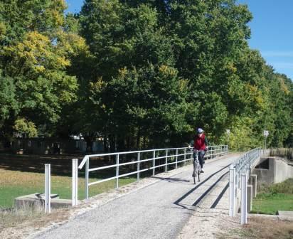
Having passed under the GAR, there is a creekside park to welcome you, with a good example of a tobacco drying shed as a backdrop. From here you need to cycle over the nice suspension bridge (which spans Happy Valley Creek), and then gradually pick up the newly constructed riverside (Ovens River) pathway.
This leads via two new bridges over the Ovens to Apex Park, just on the eastern side of town. On the way, there are many nice areas for a cool dip and/or riverside refreshment.
Having arrived at Apex Park, follow the short access road out to Standish Street (the Lake Buffalo Road), and then swing right onto Lewis Avenue, using the marked bike lane all the way, so as to get safely back to a roundabout at the GAR. The bike lane crosses from one side of the roadway to the other several times, so you need to be careful along this stretch.
Once at the GAR, cross over this main road, and make your way up Albert Street so as to intersect the Rail Trail once more, and then make a right turn to continue towards Bright.]
MYRTLEFORD to BRIGHT
This section of bike path is mostly uphill, but the great scenery more than compensates for the blubber burnt; this 30km (120 minute) section gains about 96m end-to-end (Myrtleford is at 208m, Bright is at 304m).
Assuming you stayed on the Rail Trail to get to the centre of Myrtleford; from Standish Street, the Trail continues to parallel the GAR, and emerges on the other side of Myrtleford, several hundred metres before the Burger Cafe, and another crossing of the GAR. The optional by-pass of the urban area (described above) also meets up with the Rail Trail in this section.
The Burger Cafe is a popular stop-over, and serves an excellent morning tea, lunch etc.
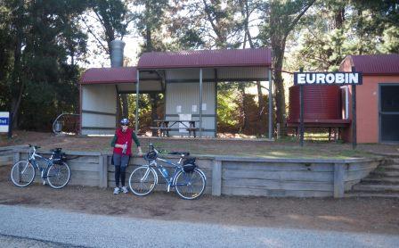
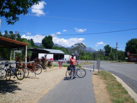
Intermediate access-egress points are Ovens (222m, 5km); Eurobin (251m, 16km), Porepunkah (279m, 24km) and Bright (304m, 30km). Eurobin and Porepunkah both have good rest stops, with toilets provided.
As you approach Porepunkah, the bike path crosses over the GAR once more, and just before the GAR Bridge over the Ovens River, dives down under the bridge, to emerge onto some riverside parklands. From here it climbs up the river terrace, and enters the township; some riders cut across the GAR directly at the bridge, but safety is always an issue with manoeuvres like this.
Porepunkah caters nicely to Rail Trail users, with a selection of cafes and take-aways lining the shopping strip. There is also a wide range of riverside accommodation on offer.
Continuing on, the Rail Trail leaves the GAR for several kilometres, passes through Porepunkah, and then swings right, crossing the Ovens River via Leven Drive.
This brings a further crossing of the GAR into view, and having crossed over the bitumen (with care as usual) it is a nice run to the centre of Bright, mostly via a tree lined avenue of the Rail Trail.
The Rail Trail finishes at the site of the Bright Railway Station, and is only about 100m from the centre of town.
Bright has a good range of shops and services, as well as several caravan parks and many motels to choose from. See the township description on the HomePage for more details.
Getting to the Rail Trail from Wangaratta Railway Station
If you are starting your journey from Wangaratta’s railway station, then the Rail Trail is quite clearly signposted, and this description, and the signage, will guide you from the Station to the suspension bridge.
Leaving the station forecourt, cross over the recessed (below ground level) railway line, so as to access Norton Street.
Cafe Little B is diagonally opposite from here, and serves a nice morning tea/lunch; on the same side of the street, and closer to the city centre, The Railyard is also a great place to call in to.
To get to the Rail Trail, you need to follow Norton Street, towards a colourful water tower, about 200m away. Swing around in front of this historic structure, and follow Docker Street for a short distance to Mackay Street (a sign-posted left turn).
This leads for a short distance down to the Rowan Street underpass (of the railway lines). Turn left here, and then pickup the pedestrian overpass (which leads across the underpass).
Once off the overpass, turn right, and then left to take the northern extension of Mackay Street through to Templeton Street.
Swing right here (but see the note below), and follow Templeton Street through to Bickerton Street, at a roundabout. Here you need to veer left for the Bickerton pedestrian bridge referred to in the main description.
Just before the pedestrian bridge, Cafe The Pre Vue, and Cafe Precinct have it all laid on for hungry riders.
Note: If you keep straight-ahead at the point where the description says ‘swing right into Templeton Street’, you can pick up Wangaratta’s riverside cycling path. The narrow laneway at this point leads down to the Ovens River, immediately upstream of the railway bridge.
Turn right at the river, and then follow the bike path upstream - leading over a suspension bridge, and then on to a similar struture.
Either cross over the river at this second bridge, and continue through to the Bickerton Street bridge, or continue straight-ahead, so as to cycle alongside Painters Island Caravan Park, and subsequently pick up the main route on the opposite side of the Bickerton Bridge to Cafe The Pre Vue.
MURRAY to MOUNTAINS RAIL TRAIL OFFICIAL WEBSITE
Intro Screen on a fresh browser page
COPYRIGHT © 1995-2023, Chris McLaughlin.