EARLY DAYS
(www.northeastvictoria.online)
There were many thousands of years of habitation by aboriginal people (for example, the Bpangerang and Jaithmathang people) in what is now called North-east Victoria.
All of this was to change with the early exploration of the North-east by europeans that began in 1824.
The event was an expedition to determine whether any navigable rivers flowed south from the Goulburn Plains of New South Wales, towards the Port Phillip District.
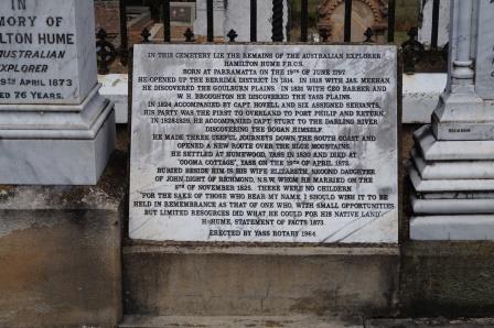
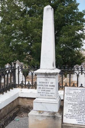
In charge of this expedition was Hamilton Hume, after whom the present day Hume Highway/Freeway is named.
Hume set out from his home at Appin (southern tablelands of New South Wales) in 1824, to explore the largely unknown country as far south as Port Phillip. His partner in leading the expedition was Captain William Hovell, after whom Lake William Hovell (on the King River) was named.
The expedition officially began just east of the present day town of Gunning, and the explorers’ route then followed the western foothills of what we now call the New South Wales and Victorian high country.
It then crossed the Murray River upstream of the Kiewa River confluence, and then in turn crossed the Kiewa, Ovens and King Rivers, passing within 13km of what is now Beechworth.
Hume and Hovell reached Corio Bay (near the present day site of Geelong) in December 1824 and then started the long journey home, along a route which is reasonably close to the present day Hume Highway/Freeway.
The Freeway does, however, travel generally to the west of the explorers’ route, thereby avoiding the foothills of the high country.
The Highway was called ’Great Southern Road’ in New South Wales and ’Sydney Road’ in Victoria until 1928, when both states agreed to rename it after Hamilton Hume (Hume is also remembered by the vast Lake Hume near Albury).
The expedition also named the Ovens and Hume Rivers, but explorer Charles Sturt later renamed the Hume as the Murray.
There was little immediate response to the Hume and Hovell Expedition. However the 1830s drought, and a general increase in demand for land, led to several forays into what is now Victoria.
Explorers McKillop, McFarlane and Livingstone reached the Omeo area from the Monaro Plains in 1835 and in 1836 Major Mitchell’s expedition crossed the Ovens River on its way south. Following all this exploration and documentation on new lands, North-east Victoria was slowly populated by europeans for the first time.
The New South Wales Governor initially tried to discourage settlement south of the Murrumbidgee, but began to lose its ability to do so when Major Mitchell’s favourable reports of ’Australia Felix’ (the Western District of Victoria) became known.
Finally in 1836 the Squatting Act was passed, and this formally paved the way for pioneer families to begin their push south.
Graziers from north of the Murray followed Mitchell’s footsteps, and many of the early leases of the Ovens and Kiewa Valleys were taken up during this period. This gradual process of settlement was speeded up following the separation of Victoria from New South Wales in 1851.
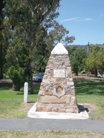
There are several memorials to Hume and Hovell in the area. For example at Murmungee, south of Beechworth, there is a memorial cairn, erected in 1924, the centenary of the expedition. Similar cairns dot the North-east, for example at Allans Flat, Ebden, Euroa, Myrtleford and Stanley.
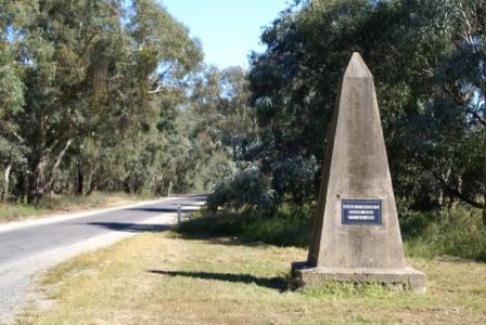
The Memorial shown here is located alongside Seven Creeks in Euroa; the following photo commemorates the Major Mitchell Expedition of 1836, and is located north-west of Chiltern.
One of the first settlements in the North-east was at Ovens Crossing (now Wangaratta). In 1838 at the confluence of the King and Ovens Rivers the settlement was launched. Major Mitchell’s expedition crossed the Ovens River at the site of the township in 1836, and a plaque commemorating the event can be viewed in the local Historical Society Museum (see the Wangaratta Heritage Trail).
The Faithfull brothers were amongst the first settlers in the North-east. George Faithfull took up land near Wangaratta and William Faithfull went further south, to the present day site of Benalla.
Despite several set-backs, much of the prime land of the Ovens, King and Kiewa Rivers had been taken up for agriculture by the 1850s.
In the Kiewa Valley, Bonegilla was first taken up in 1835, Tangambalanga in 1838, Gundowring in 1840, Dederang in 1848, Tawonga in 1847 and Kergunyah in 1851.
Coinciding with the peak period of land settlement, Victoria became a colony in its own right in 1851, and many local government areas were proclaimed; for example, Yackandandah was proclaimed in 1862.
Soon these new rural areas were to be shaken by the discovery of gold!
Intro Screen on a fresh browser page
COPYRIGHT © 1995-2020, Chris McLaughlin.