ROSE RIVER VALLEY
(www.northeastvictoria.online)
TRAVELLING TIME: About two hours (Myrtleford - Whitfield).
DISTANCE COVERED: 62km (Myrtleford - Whitfield).
OVERVIEW MAPS: Spatial Vision, Touring the Victorian Alps.
DETAILED MAPS: Rooftop Maps, Bright - Mansfield Adventure Map.
SHOPS and SERVICES: Wangaratta and Myrtleford are the closest main commercial centres to the start of this tour, and both offer a good range of shopping and services. Once in the King Valley, there is a general store, a hotel, cafes and a fuel outlet at Whitfield, and a cafe at Cheshunt.
ACCOMMODATION: Commercial camping areas (and a range of other accommodation options) at Wangaratta and Myrtleford. Commercial caravan parks (and motel units) at Whitfield.
WHEN TO GO: Avoid any sustained wet weather, and any super-hot days.
ROADWAY DETAILS: A good bush road, although quite narrow in places. No problems in the dry for any vehicle; the route is not recommended for caravans; camper-trailers should be 4wd rated.
OTHER INFO: A nice neat tour, with plenty of contact with running water. Distances quoted may vary by several kilometres from one vehicle to another.
Starting out from Myrtleford, access is via the sign-posted Lake Buffalo Road (also called the Buffalo River Road). This leads for about 20km past vines, olive groves, and former tobacco farms to the scenic Lake Buffalo. Landmarks on the way include Nug Nug Reserve (excellent camping amongst tall timber) at 13km, and Osbournes Bridge after 16km. As well, there are continuing excellent views of the west side of the Mount Buffalo Massif, including the dominant feature known as The Horn.
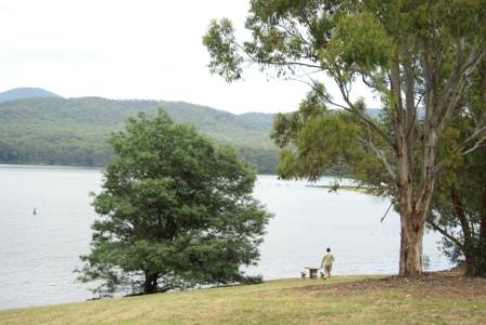
There is a nice picnic area to the left (just before the crossing the Lake Buffalo spillway) and this makes a good spot to take-five before hitting the gravel.
As you cross the spillway there are good views of the Lake, with the not too distant high country again providing a nice backdrop. A few kilometres beyond the spillway, there is a left turn to the Marshalls Ridge Recreation Area; this leads to a nice lakeside location, and like the picnic area just before the spillway is a good place for lunch or morning tea.
The bridge over the Rose River is encountered at 31km, and the bitumen soon disappears in the rear vision mirror as you swing right onto the Rose River Road.
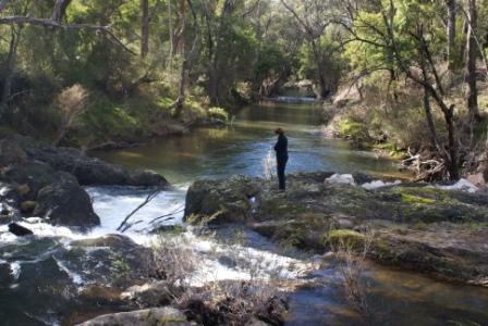
A short four kilometre run leads to a bridge over the Dandongadale River; this is a tributary of the Rose River, which in turn is a tributary of the Buffalo River. Way upstream, the Dandongadale River is home to the Dandongadale Falls, the longest single drop falls in Victoria (more details in the Lake Cobbler description).
At about the 41km mark there is an unsignposted right turn that leads over a bridge to the Black Range State Forest. Just over the bridge, there is a small informal camping area.
In the next six kilometres there are three more bridges over the Rose River; all of them provide nice views of the River, but parking is not brilliant at any of these bridges.
Leaving the bridges behind, there is now a sustained climb up to Gentle Annie Gap, the watershed between the Rose River-Buffalo River and the King River.
The Lake Cobbler access road is encountered at the 48km mark, and is also known as the Upper Rose River Road, Cobbler Lake Road and Lake Cobbler Road depending on whose map you are using. The turn-off is on the left and is not very clearly marked. From the turn-off it is a two hour trip in, and a two hour trip out, with a total distance of about 60km. See the separate description for more details.
Bitumen is now soon encountered, and the turn off to Paradise Falls is the next landmark, being about 60km from Myrtleford.
This makes an interesting side trip (a 22km loop), with the Falls being a series of spectacular u-shaped waterfalls on Stony Creek, a tributary of the King River.
From the turn-off, the meandering un-sealed access road leads to a car park and picnic area set in an area of dry, open forest, with no inkling of the moist, spray filled gully a short walk away.
At the end of the access road, the walking track to the Falls is signposted from the car parking area, and winds its way through open forest, gradually descending off the plateau, to meet with Stony Creek and its secluded waterfalls.
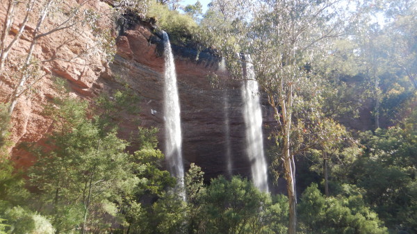
There are two major falls here, both quite similar with each watercourse having cut a semi-circular arc through conglomerates and sandstones. This has created an extensive overhang in each case and it is quite easy to walk, or sit, under the waterfalls, and take a refreshing shower every few minutes.
Little Falls have a straight drop of 17m, whilst Paradise Falls have a drop of 31m.
The return to the car park is via the same route, and after the walk it is pleasant to take advantage of the picnic-barbeque facilities near the car park.
Returning to the bitumen, and continuing on towards Cheshunt, the end of the tour is not far away. See the King Valley Tour description for a return to Wangaratta via Whitfield, Moyhu and Oxley.
The Falls are also easily accessible from Cheshunt; just take the Rose River (Myrtleford) Road, and swing right on to the sign-posted detour.
Intro Screen on a fresh browser page
COPYRIGHT © 1995-2020, Chris McLaughlin.