EUROA - STRATHBOGIE RANGES
(Balmattum Hill, Gooram Falls, Polly McQuinns Weir
and Mount Wombat)
(www.northeastvictoria.online)
TRAVELLING TIME: Allow 3-5 hours, depending on your interests.
DISTANCE COVERED: About 90km.
OVERVIEW MAPS: Rooftop Maps, Bright - Mansfield Adventure Map.
GPS and DETAILED MAPS: Rooftop Maps, Bright - Mansfield Adventure Map. The tour is also covered by VicMap 1:50 000 Tallangalook; available in print, and GPS (digital), format.
SHOPS and SERVICES: Euroa has a reasonable range of shopping and services, as well as some good eateries; Merton has a general store, and a fuel outlet; Strathbogie Village has a general store/cafe. Euroa is also home to the iconic Seven Creeks Hotel, renowned for its pub grub.
ACCOMMODATION: Euroa has several motels, and a caravan park.
ROADWAY DETAILS: A mix of sealed, and gravel roads; no problems in dry conditions. There are some narrow roadways in the tour, and for this reason camper-trailers and caravans are not recommended on this route.
WHEN TO GO: Avoid sustained wet weather, and any super-hot days.
OTHER INFO: This is a great drive with plenty to see and do. Distances quoted may vary by several kilometres from one vehicle to another.
Balmattum Hill
Starting off from Euroa (with the tripmeter at zero), this scenic tour begins by taking the Strathbogie Road (Templeton Street) from just north of the Seven Creeks Bridge, and following this roadway south-east towards the Strathbogie Ranges, making a wide sweeping loop back to Euroa.
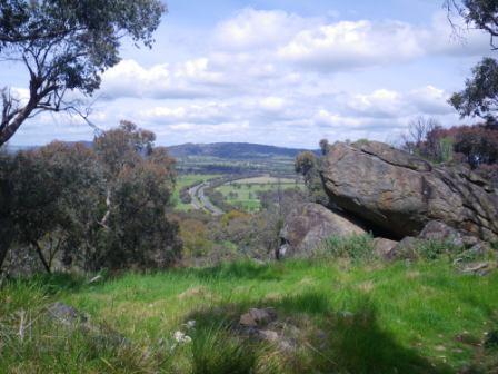
Templeton Street soon gets a rural feel to it, and follows Seven Creeks upstream, away from the township. Passing under the Hume Freeway, via a cavernous overpass, Balmattum Hill comes up on the left, and offers a nice diversion - The Federation Walk [AWTGS-3] . This is an enjoyable walk that leads to the summit area of Balmattum Hill, a local highpoint of the Strathbogie Ranges.
The access road quickly leads to a small car parking area, and from here the initial part of the walking tracks leads uphill to a picnic rotunda.
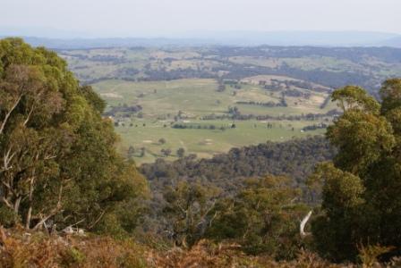
Continuing upslope from here, the track is now quite narrow, and winds around the hillsides on a relentless quest for the summit. There are many nice views on the way up, including glimpses of Euroa township and the surrounding ranges. The geographic position of the township is also quite apparent, with the cleft between the ranges providing all the answers as to why Euroa is situated where it is.
The walk takes about 90 minutes to complete, including an allowance for time spent having morning tea or lunch on the bench at the top.
You can also access this walking track via the APEX Bicentennial Walking Track from near the centre of Euroa. See the township description for more details.
Forlonge Memorial
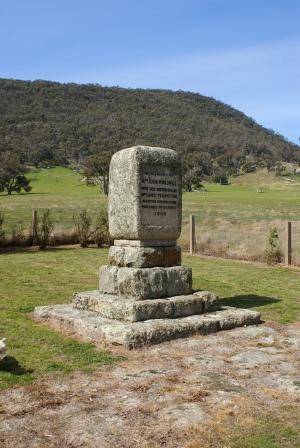
The Forlonge Memorial Road (also known as Forlonge Road) comes up on the right, about 7.5km from town, and this leads onto a 12km run of gravel that takes the route through to the C366 (the Euroa - Merton Road).
The Forlonge Memorial is on the left, at about the 12.5km mark, and commemorates the importation (for the first time) of fine wool sheep into Victoria.
This was in 1835, with the Forlonge and Templeton Families being honoured on the granite obelisk mounted plaque. The setting of the Memorial is quite fitting, being down on the valley floor, sandwiched between many granite studded, rolling hills.
Gooram Falls
Continuing on from the Forlonge Memorial, it is about three kilometres to an unsignposted right turn, which can be ignored, and then a short run to a cross roads, where a right turn is required.
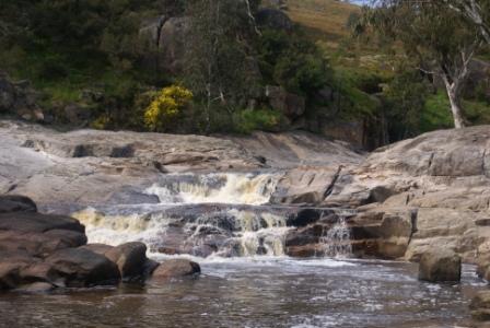
This puts you back on the bitumen, and from here it is another short run to join up with the C366. Turning left here, it is about two kilometres to the first of two turn-offs that lead to Gooram Falls. The Falls are on Seven Creeks, a rugged stream that has its headwaters in the Strathbogie Ranges, with an extensive flood plain that stretches out from downstream of Euroa.
On the way to Euroa from the Ranges, Seven Creeks covers a precipitous path, with rapids, waterfalls and cascades being the order of the day. Most of these features are inaccessible, but Gooram Falls are within easy reach, and make an interesting stop-over.
This first access point leads downslope to a small vehicle turn-around, with the 400m walking track to the Falls [AWTGS-3] being signposted to the left. This is a narrow pathway, with a tendency to become boggy in wet conditions, but it quickly leads to the base of one of the larger cascades on the Creek. The Creek divides in two just below this cascade, with the vehicle turn-around referred being close to where the two branches reunite.
If you continue walking upstream from the first cascade, there are some more cascades to enjoy, as well as some excellent rocky scenery.
On our last visit there were no picnic amenities at this access point, however, there is a small toilet block, accessible by making a hard left turn, just as you enter the vehicle turn-around.
Back on the C366, it is about a kilometre to the second of the Gooram Falls access points; like the first one, this access point is also not too well signposted.
The car parking area here is much better than the first, and this makes it a more popular access point, with the Falls also being closer.
Strathbogie Gap and Merton
Back on the C366, it is about five kilometres to Strathbogie Gap, the highest point on this road, with some great views on the descent into Merton. The surrounding countryside is also very enjoyable, being mostly native bushland, with plenty of granite outcrops to provide added interest.
Just to the east of Merton, the C366 joins up with the B300 (the Maroondah Highway), and the route continues by swinging left at this point, following the B300 for about 1.5km to the Strathbogie turn-off (to the left).
Polly McQuinns Reservoir
About three kilometres into the Strathbogie Road, there is a fork in the road where you need to keep right (that is, take the Strathbogie Road, not the Old Strathbogie Road). This leads into a very scenic section of road, with plenty of native bushland, granite outcrops and excellent views. The roadway through here is quite narrow, so putting on the headlights is a good move.
After about six kilometres, this part of the route emerges into some partially cleared country, with more excellent views to be enjoyed. Keep straight-ahead at the Dukes Road intersection, and then swing left into Coach Road, about 11km from the B300.
Follow Coach Road for about four kilometres, to a t-junction at Kippings Road. Turn right at this point, and follow this roadway through to another t-junction, where Galls Gap Road goes off to the left, and Polly McQuinns Road is to the right.
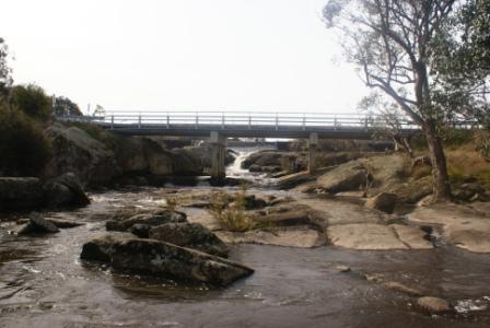
Turn left at this intersection, and it is only a few hundred metres to where the roadway crosses over Seven Creeks, with a cascade being visible to the left, and the wall of McQuinns Reservoir being visible to the right.
Having crossed over the Creek, there is a large pull-in on the left, with plenty of car parking space, and a small toilet block. You can walk, or drive, down to the water's edge from here, where there are some basic picnic amenities, and some nice rocks to lounge around on.
Strathbogie Village
Continuing on from McQuinns, cross back over the Creek, and then turn left, taking Polly McQuinns Road towards Strathbogie Village. From here it is a nice six kilometre run to the village, with a t-junction at the Merton - Strathbogie - Euroa Road appearing after about five kilometres. Turn left here, and it is a short run to the environs of Strathbogie.
Just before entering the village, there is a nice picnic area on the left, just after crossing Seven Creeks. The village itself has a small general store cum cafe, and it is pleasant to take time out to wander up and down the main street.
The Bridge to Bridge Walk provides an excellent opportunity to park the car and stretch those legs. The walk follows Seven Creeks and Spring Creek for about 2.5km and has plenty of shade, and birdlife. See "strathbogieranges.org.au/local-walking-guides" for more details (link below).
Mount Wombat
Continuing on from Strathbogie, there is another picnic area, just over the next bridge, with a nice pedestrian bridge alongside the road bridge and picnic area.
Not far out of town, take the signposted fork to Strathbogie cemetery, and follow this narrow-ish roadway through to the left turn, signposted Mount Wombat Native Plant Reserve. This leads to another narrow-ish bush road (a no-go zone in wet weather) that winds around through some excellent forest areas, finally reaching the summit of Mount Wombat.
The summit is at about 800m, and has some great view points. You have to share this high ground with several radio, TV and phone towers, so all is not totally photogenic in your immediate surrounds.
However, the views are amazing, with great vistas that include places like Mount Buller and the not-too-distant high country. In the opposite direction, there are expansive views of the rolling hills that lead down to Euroa, and the never-ending flood plain beyond.
Returning to the t-junction at the Mount Wombat Native Plant Reserve signpost, turn left, and follow this through to pick up the Merton - Strathbogie - Euroa Road once more.
This soon begins a steady descent, passing through the small community of Kelvin View, with many more great views of the valley floor. Once having reached level ground it is only a short distance to where the Forlonge Memorial Road goes off to the left, and then a little over seven kilometres to Euroa.
Strathbogie Shire Walks Brochures (PDFs)
Intro Screen on a fresh browser page
COPYRIGHT © 1995-2023, Chris McLaughlin.