TAWONGA GAP
(OVENS VALLEY - KIEWA VALLEY)
(www.northeastvictoria.online)
TRAVELLING TIME: Allow about an hour, so as to have time to stop at one of the Lookouts.
DISTANCE COVERED: About 30km.
OVERVIEW MAPS: Touring map of Victoria.
DETAILED MAPS: None required.
SHOPS and SERVICES: Bright has a good range of shops and services, as does Mount Beauty.
ACCOMMODATION: Bright has a wide range of accommodation options, including riverside caravan parks; Mount Beauty has a good range of holiday accommodation, including a riverside caravan park.
WHEN TO GO: Anytime of the year.
ROADWAY DETAILS: Bitumen all the way, albeit narrow in places, with some tight bends, and blind corners.
OTHER INFO: A scenic link between two major valleys of the North-east, the route described here is also part of the Bogong Alpine Way (see Homepage for more details of this route). Distances quoted may vary by several kilometres from one vehicle to another.
This 30km scenic link, between the Ovens and Kiewa Valleys, begins by taking the Great Alpine Road (GAR) from just north of Bright, and turning onto the C536 at Germantown. There are two impressive lookouts en route, and this is a popular tour.
Having turned off the GAR, the road crosses over the Ovens River, and soon begins to climb; meandering past several nut plantations before entering forested areas.
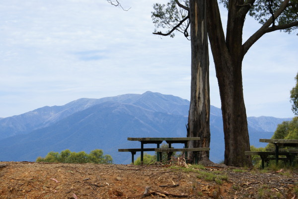
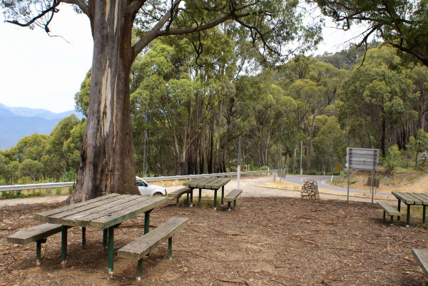
It is then a steady climb over the range that helps separate the Kiewa and Ovens River systems, and the summit ridge is reached quite abruptly. There is a pull-in just before the ridge (to the left) where there is plenty of room for car parking and leg stretching.
The views are very impressive, and there are several tables and chairs set amongst the open forest, providing a very comfortable resting place.
If you are feeling energetic there is another lookout (signposted) which can be reached by crossing over the road (take care, this is a blind corner) and following the track to the top of the hill, 1.6km away.
A plaque at the ridge commemorates the opening of this road.
| History Bright-Tawonga Road 1895-6 |
| This road linking the Kiewa and Ovens Valleys was built as the result of years of agitation and a successful petition to the Minister of Public Works by farmers of Tawonga who wished to get their produce to Bright. A dray road was required over the steep hill to the Bright railhead 32 kilometres away. Severance of the Tawonga area from the Shire of Yackandandah was a condition. In 1895 an area of 177 sq/km was added to the North Riding of the Shire of Bright conditionally on the road being completed within 12 months of the severance date. |
| Contractors using pick and shovel labour and wheelbarrows struggled with its construction and completed the works within the prescribed time. Wages paid were 70 cents per day. To finance the work a 20 year loan of $4,000 was floated by the Council of the Shire of Bright. |
| The official opening was held on 19th March 1896. A 4 horse dray conveyed the Official Party at the head of a procession of cars, coaches, buggys and horseback riders leaving Bright at 8.15am. Equestrians reached the Gap at 12.15pm. The 9 mile trip down to Tawonga took only 3/4 hour. 300-400 people including District Members of Parliament, Shire Councillors and Presidents of Shires of Bright, Beechworth and Yackandandah heard the Hon Gavin Duffy, Post Master General declare the road officially open. |
| B Lyndon Smith was given a Testimonial in appreciation of his work - not only had he built the first mountain road solely financed by the Shire, but he had combined the duties of both Shire Engineer and Shire Secretary at a cut in salary due to the current depression. |
Back on the road, and a little further down the hill (that is, on the Tawonga side of the ridge) there is another pull-in, this time for Sullivans Lookout. From here, the peaks surrounding Mount Beauty can usually be seen quite clearly, and the view makes an excellent photograph.
Springtime scenes are particularly rewarding as many peaks, including Mount Bogong (Victoria’s highest peak), are usually snow capped until late November. Down on the floodplain, the course of the Kiewa River can be picked out, as well as the township of Mount Beauty.
If you have the choice, both of the lookouts are best approached from the Bright direction (the direction being described). If you pull over to the lookouts whilst driving up from Mount Beauty, great care is required as you must pull over to the ’wrong’ side of the road, where visibility is restricted by sharp bends.
Continuing downhill on the Mount Beauty side, Lawlers Springs (on the right, about two kilometres after Sullivans) has nice spring water, but take care with passing traffic when filling your bottles.
The road now gradually descends to the Kiewa Valley Highway, about midway between Tawonga and Mount Beauty, with more excellent views of the Kiewa Valley.
Take care when entering the Highway as the junction is on the brow of a hill, and there are a couple of blind spots for drivers entering the Highway, and for those already on it. Tawonga is to the left of the junction, and Mount Beauty is to the right.
See the separate description of Mount Beauty township for details on the town, and the Albury-Wodonga - Mount Beauty Tour for details of the Kiewa Valley Highway.
Intro Screen on a fresh browser page
COPYRIGHT © 1995-2020, Chris McLaughlin.