WARBY - OVENS NATIONAL PARK
(www.northeastvictoria.online - smartphone site)
Sunrise Walking Track [AWTGS-3]
Access to this great walk is by turning west at the Delloro Road/Warby Range Road cross-roads.
This unsealed roadway leads for about a kilometre to a small turn-around area, where there is parking for about eight vehicles.
Alternative access is to take Delloro Road from the Wangaratta - Glenrowan Road (that is, the former Hume Highway), taking care at the cross roads referred to above.
A series of walking tracks leads off from the turn-around, so there are many combinations of walks to choose from. The loop described here (a slightly lengthened version of the full Sunrise Track) covers many of the more interesting aspects of this part of the Warby’s, without going too far from your vehicle. Distance covered is about 6.7km, the time required is about three hours, and the walk is graded as AWTGS-3.
The Parks Victoria info PDF and/or the 1:50 000 scale topographic map Wangaratta is also required. You might also want to take a photograph of the colour coded map at the start of the walk.
Note that this walk requires a pair of formal walking shoes/boots, as well as a set of trekking poles.
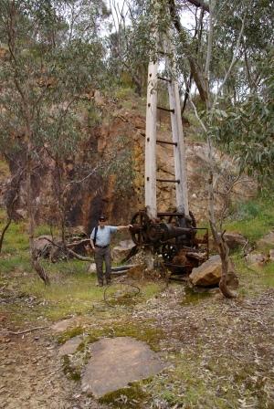
Starting off from your vehicle, locate the ’Quarry Lookout 700m’ sign, and follow this blue coded route off to the left. This is a former vehicular track, so the walking is not too hard, and the route follows easy contour lines, gradually climbing up to a former quarry (750m away) that was the source of the stones used to construct many of Wangaratta’ best known buildings, including the Anglican Cathedral.
There are some great views to be enjoyed from the quarry site, as well as some extraction machinery that is slowly rusting away. On the way upslope, there are several former explosive storage boxes; small concrete bunkers set into the hillside at the side of the roadway.
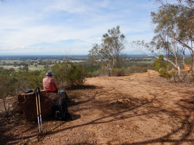
Items of interest from the lookout are the Eldorado Hills, Mount Buffalo, the Wabonga Plateau and (on a clear day) Mount Cobbler.
Leaving the quarry behind, the little blue arrows guide you onwards, and upwards, with some nice views to the north, followed by a gradual descent to meet up with the green coded Sunrise Loop at a t-junction. This is about a kilometre from the start, and you need to turn right here, and follow this narrow-ish (green coded) walking track through to another t-junction.
This is Bracken Link, at two kilometres from the start; see the notes at the end of the description for more on this route.
However, at this stage, keep straight-ahead here, and continue following the winding track, all the way through to an excellent hill-top. Here, there are great views, and some handy fallen logs that make nice rustic seats for morning tea or lunch.
This is at about 3.5km from the start, and continuing on, the route leads down to a vehicular track, where you need to turn right.
This is a closed track (management vehicles only) and is infrequently used.
Follow this track through to a signposted right turn (3.7km) that is the continuation of the Sunrise Walk.
The route now continues its meandering progress, meeting up with Bracken Link once more (5.1km), albeit at the opposite end to that previously seen.
At 5.6km you will be back at the second t-junction encountered on the outgoing journey, and here you need to turn left, and follow this through to the first t-junction.
Keeping straight-ahead here, it is about 300m through to the car park, and the finish of the walk (6.7km).
| Sunrise Track | Section km | GPS |
| Quarry Lookout | 750m | 36/22/24.5 : 146/14/15.3 |
| 1st t-junction | 990m | 36/23/27.9 : 146/14/08.0 |
| 2nd t-junction | 1.37km | 36/23/32.4 : 146/13/57.1 |
| Bracken Link | 2.0km | 36/23/27.9 : 146/13/40.5 |
| Hill Top | 3.06km | 36/23/16.4 : 146/13/22.06 |
| vehicular track | 3.48km | 36/23/09.6 : 146/13/14.1 |
| leave vehicular track | 3.7km | 36/23/03.5 : 146/13/12.6 |
| Bracken Link | 5.07m | 36/23/19.4 : 146/13/51.3 |
| back at 2nd t-junction | 5.6km | 36/23/32.4 : 146/13/57.1 | back at 1st t-junction | 6.4km | 36/23/27.9 : 146/14/08.0 |
| car park | 6.7km | 36/23/37.0 : 146/14/20.2 |
The red coded Bracken Link provides a short-cut from the main walk, and takes about three kilometres from the overall distance.
This short-cut leads to a delightfully sheltered glade, where there are many excellent examples of grass trees, and (of course) plenty of bracken fields.
Having made it out to the other side of Bracken Link, turn right, picking up the green coded Sunrise Loop once more.
COPYRIGHT © 1995-2020, Chris McLaughlin.