WARBY - OVENS NATIONAL PARK
(www.northeastvictoria.online)
Mount Glenrowan [AWTGS-3]
Access to this great walk is via the high point of the winding path of Taminick Gap Road, as it climbs up over the Warby Range.
Once up on high ground, the walking track to Mount Glenrowan (Ridge Track) is to the south, and there is plenty of car parking space here, on both sides of the bitumen.
Mount Glenrowan is the highest point for many kilometres around, and was (reputedly) a haunt of the Kelly gang, and certainly offers an advantageous view of the surrounding landscape. The lookout near the summit was named Morgans Lookout, after a member of the Kelly Gang.
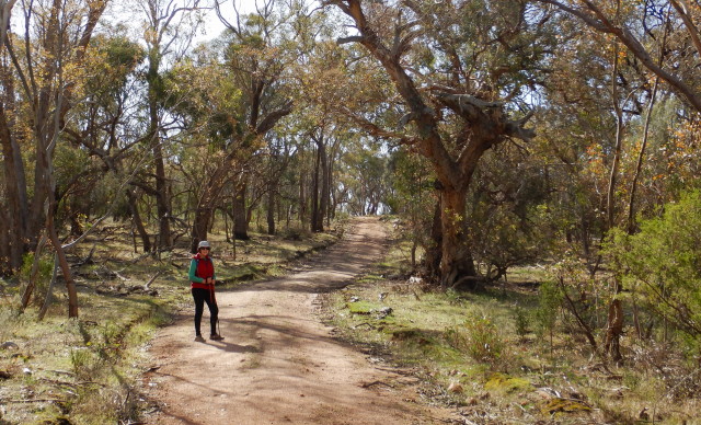
The walking track covers about 9.8km of interesting terrain, with the return trip taking up to three hours. The track is mostly undulating, however there is an initial steep section of about 400m of sealed track to gasp your way up.
Swing right just before the first telecommunications tower, and step it out on the gravel for the next 60 minutes to Mount Glenrowan and Morgans Lookout.
Views are excellent, with the Winton Wetlands (Lake Mokoan) being visible to the right on the outgoing section. This is followed by many nice views of the floodplain, way down below, with the mosaic caused by different land usages being quite noticeable.
Nasons Road is off to the left at about 800m, and can be ignored, except that the Nason Family were amongst the earliest land holders in this area. A plaque at this point commemorates their land grant to the National Park.

The track to Chick Hill (an optional 800m detour) is to the left at about 2.1km, Chick Hill being a popular destination for morning tea, and its great views.
[If you take this detour, the track leads to a sign-posted y-junction, where you need to keep left to reach Chick Hill.
However, if you swing right at this point, there is a 300m walk to a disused waterhole, a legacy of the cattle grazing days - a great place for bird watching.
Return to the Chick Hill access track by retracing your steps.]
Continuing on Ridge Track, ignore all of the side tracks, and follow the main pathway of gravel all the way to the second telecommunications tower, and then walk around this structure to the right, to get to the main lookout area.
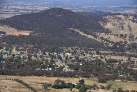
Expectedly, the views are really excellent, with Mount Buffalo being clearly visible, along with much of the northern side of the high country, as well as the township of Glenrowan, neatly laid out down below.
The geographical significance of the siting of Glenrowan is also apparent from up here, with the township clearly dominating a major gap in the ranges.
During the winter months the following procedure will help identify some snow capped alpine landmarks; looking at the quarry (directly opposite the lookout) Mount Buller is to the right, Mount Stirling to the left; swinging to the left reveals Mount Cobbler, then the Wabonga Plateau (the flat topped mountain), then Mount Buffalo, followed by Mounts Hotham, Feathertop and Bogong.
The return route is by following your footsteps back along Ridge Track, however a small detour can be made at Bluff Track.
This is a signposted turn-off to the left, and leads for about 300m to a granite outcrop, with great views towards the west.
Some walkers use this as an alternative lunch spot, but in either case it makes an interesting 600m ‘there-and-back’ option.
COPYRIGHT © 1995-2024, Chris McLaughlin.