WARBY - OVENS NATIONAL PARK
(www.northeastvictoria.online)
Casuarina and Moonlight Tracks [AWTGS-3]
These two tracks provide an alternative to the Mount Glenrowan Walk along Ridge Track, however this version requires expert bushwalking experience, a formal set of walking boots (not shoes), trekking poles, a topographic map of the area, and a GPS with detailed topo maps.
You will also need about two litres of water per person, and a good ration of food/snacks.
As for the Mount Glenrowan Walk, the action starts via the high point of the winding path of Taminick Gap Road, as it climbs up over the Warby Range.
Once up on high ground, the walking track to Mount Glenrowan (Ridge Track) is to the south, and there is plenty of car parking space here, on both sides of the bitumen.
This adventure covers about 14km of interesting terrain, with the return trip taking up to five hours. The track is mostly undulating, however there is a steep-ish descent, and a steep-ish ascent with a very loose surface.
Stepping it out from the start, swing right just before the first telecommunications tower, and then continue on the gravel of Ridge Track to where Casuarina Track heads off to the right.
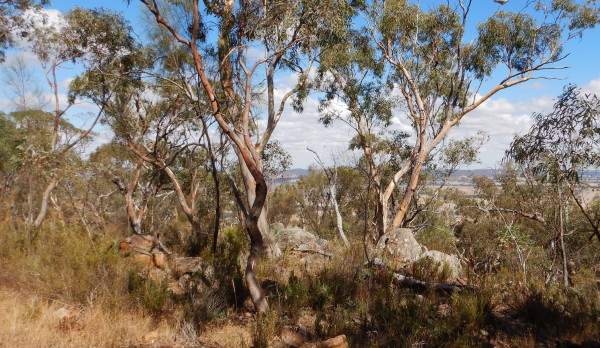
On the way, the views are excellent, with the Winton Wetlands (Lake Mokoan) being visible to the right. This is followed by many nice views of the floodplain, way down below, with the mosaic caused by different land usages being quite noticeable.
Casuarina Track meanders around through the bushland, heading mostly downhill, and you need to follow this route all the way to where it meets up with Moonlight Track, about three kilometres from the start.
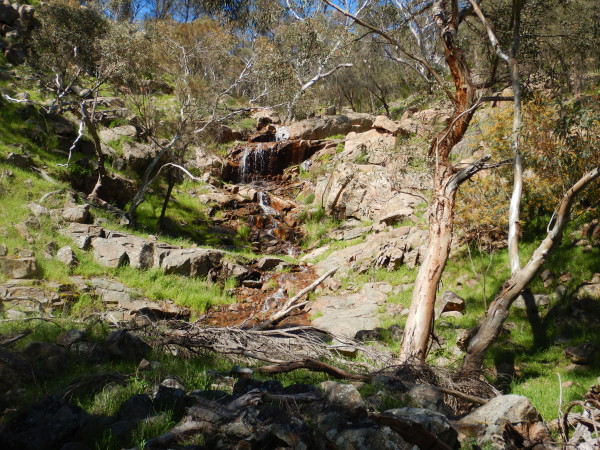
Once at Moonlight Track, you need to swing left, and follow this easy route for several kilometres, taking time to admire some more great views. These include the not too distant Mount Meg (to the right) and an un-named waterfall (to the left; GPS 36/25.540 : 146/12.520; see photo)
The roadway makes a gradual climb, and then starts a more serious climb to the left, so as to join up with Ridge Track. This section is very loose, and you will need the support of those trekking poles.
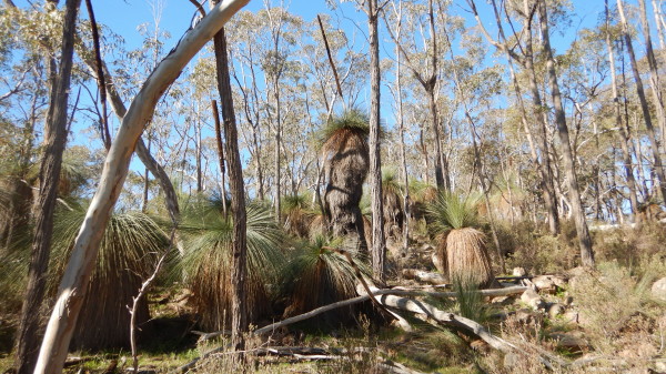
Once again, don’t walk and gawk at the same time, but take time out to admire the floodplain views, as well as the excellent stands of grass trees.
Having reached Ridge Track (about 8.5km from the start) the options are to turn left, and follow this scenic route back to the start, 3.8km away, or to swing right and follow this through to Mount Glenrowan (see the Morgan's Lookout description for more details on this).
[An even more rugged (AWTGS-4)alternative to this route involves taking the single file footpad that leads off to the right from the first part of the walk (about 250m from the start).
This is at GPS 36/24.712 : 146/12.743, and leads to a narrow, meandering, footpad that is not always easy to discern. The essential rule here is to basically head west, taking care with placement of your feet at all times.
Landmarks on the way include crossing a small creek, some beautiful grass-trees, and great views.
The key landmark however is to cross over a disused roadway (Casuarina Track) and to keep heading to the west from here.
After about a kilometre the environs of the track widen out, and Moonlight Track comes into view.
Swing left here, and continue following the main description.]
COPYRIGHT © 1995-2021, Chris McLaughlin.