WARBY RANGES LOOP
Highlights of the Warby Ranges
(www.northeastvictoria.online)
TRAVELLING TIME: Allow up to three hours depending on your interests. There is plenty to see and do, so a repeat visit is always on the cards.
DISTANCE COVERED: 70km.
OVERVIEW MAPS: Touring map of Victoria and/or Touring the Warby Range (available free from local Visitor Information Centres).
DETAILED MAPS: Touring the Warby Range (available free from local Visitor Information Centres); The Parks Victoria website (see link below) also has some handy PDF downloads, with maps, and further information, on the Park.
If even more detail is required, the VicMap 1:50 000 map sheets are Wangaratta and Wahgunyah. Note that some maps of the Warby Ranges have missing roads/tracks, misplaced road junctions and wrongly classified roads.
SHOPS and SERVICES: Wangaratta has a full range of shops and services; Glenrowan has several small retail outlets, and a fuel outlet.
ACCOMMODATION: Wangaratta has a wide range of accommodation options, including a nice riverside caravan park; Glenrowan has a nice bushland caravan park, and a motel.
WHEN TO GO: Avoid any super-hot days, and any sustained wet weather.
ROADWAY DETAILS: A mix of bitumen and gravel surfaces; no problems in dry conditions.
OTHER INFO: A great road trip, with plenty of interest and excellent views. Distances quoted may vary by several kilometres from one vehicle to another, and will need to be adjusted if you visit any of the wineries, as these have quite long driveways. See the Wineries Listing for further details of the wineries mentioned in the text.
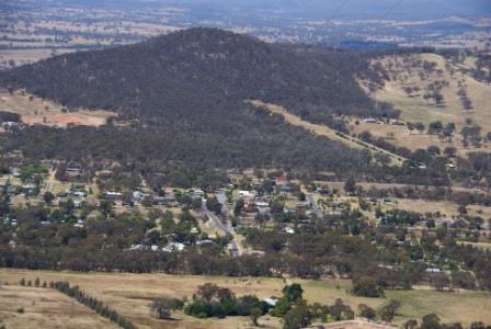
This interesting tour loops around the Warby Range, conveniently located to the north-east of Glenrowan (west of Wangaratta) with an interesting network of walking tracks, and good views over the surrounding floodplains.
The drive outlined here notionally starts just north of Wangaratta, however access is easy from many other places such as Glenrowan and Benalla. These alternative access points are described below the main text. It is not necessary to complete the loop in one session; there are many different points of interest, so multiple repeat visits are a good option.
The Warby Range was first documented by explorer Major Mitchell in 1836; it was originally called Futters Range, but was later renamed after an early settler of the Glenrowan area, Ben Warby. The Warby Family arrived in the area in 1844, and were contemporaries of the Rowan Family, after whom Glenrowan township was named.
Much of the Warby Range was declared a State Park in 1979, and with the addition of the Killawarra and Boweya State Forest, was declared a National Park in 2008. A large section of the Lower Ovens River, and its floodplain, were also included into the National Park at this time, hence the name Warby Ovens National Park.
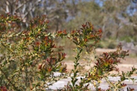
The Warby section of the Park is centred on an isolated group of granitic intrusions, and has vegetation typical of rocky/sandy soils. The open woodland of this section offers plenty of habitats for birdlife, including rosellas, robins and eagles. Springtime wildflower blooms include grevilleas and orchids, whilst other plants found in the area include spur-wing wattle and sandalwood, both of which are not common in Victoria.
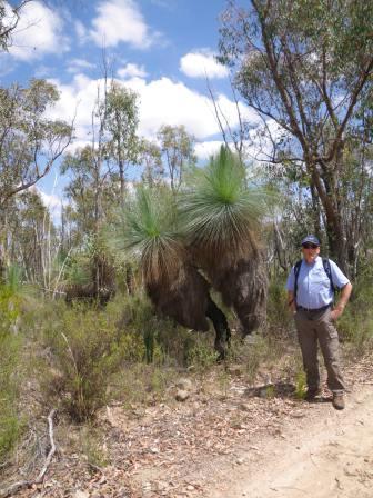
An interesting feature of the Park is the large number of grass trees; these grow to about four metres, and are typically found in the open ground of the woodland areas. The Park is also one of several areas in Victoria where the Box-Ironbark ecosystem is preserved.
The best time of year for exploration and walking in the Warby Range is late winter, and early spring, as this ensures a good display of wildflowers, and reasonable flows over the waterfalls. However, at any time of the year, many good views await you.
THE DRIVE
The tour notionally starts at the intersection of the Wangaratta - Yarrawonga Road and Wangandary Road, on the north-west corner of the Wangaratta urban area. However, access to intermediate points is easy, so you can start-stop wherever you like.
Briens Gorge
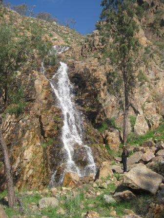
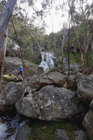
Assuming that you are going to follow the ’official route’, follow Wangandary Road for about 5.5km, to where it makes its first significant turn (a wide sweeping bend to the right), but swing left just around this bend, following the signage to the scenic Briens Gorge and Waterfalls (also known as Jubilee Falls).
The access road to the Falls swings past Jubilee Golf Course, and then terminates at a small car parking area. From here, the reasonably distinct walking track [AWTGS-3] leads off to the right, following the running water upstream, to a scenic cleft in the landscape that is filled with water in wet conditions.
Allow about 15 minutes to get to the cataract, and about 15 minutes to get back to the carpark.
Ryans Lookout
Return to Wangandary Road, and swing left, following the bitumen around a few more wide bends, and beginning the ascent of the eastern slopes of the Warby Ranges.
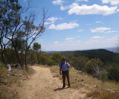
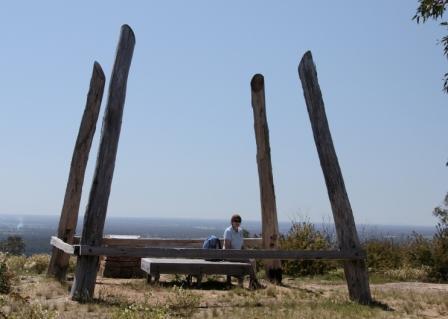
From the Briens Gorge turn-off it is a little under five kilometres to the Ryans Lookout turn-off, where a right turn leads to a small car parking area, with a short stroll taking you to some excellent views to the east (Wangaratta and the distant high country). The usual day visitor amenities are provided at the Lookout, as well as a toilet block.
About two kilometres past Ryans Lookout, the gravel surfaced Adams Road goes off to the right, and leads after about 2.5km to Tower Road, with the Spring Creek Picnic Area being to the right at this junction (the picnic area has tables and seating, with plenty of shade from trees, and some nice rocky scenery to admire, and is a nice place to stop-over for morning tea or lunch).
Warby Ranges Fire Observation Tower
Swing left onto Tower Road, and then almost immediately right onto Cox Road, following the signage through to the former Warby Ranges Fire Observation Tower. The last 800m or so to the tower are a little cobbled, and you may want to take the opportunity to do some leg stretching, rather than drive all the way to the Tower.
In either case, once at the car park, there are excellent views off to the right (of Wangaratta and the Ovens-King Floodplain) as well as to the left (of the northern ramparts of the Warbys, and the Ovens-Murray Floodplain beyond).
The observation tower at this location was first commission in the 1950’s and remained in use until the late 1990s (fire spotting in this part of the North-east is now undertaken by the observation towers at Mount Pilot and Mount Stanley). The original trestle base of the tower is all that remains, and a story board here relates the complete history of the tower.
Before moving on (or having some food/drinks) check out the stone cairn about 50m north-east of the tower. This is (or was) a survey mark constructed by the Australian Army in 1941; there were widespread fears of an invasion at this time, and the survey mark helped improve the mapping of the area (just in case!).
Pulling away from the Tower, and returning to the Adams Road-Tower Road intersection should produce something like 19km on your tripmeter.
Tower Road picnic areas
Turn left back onto Adams Road, which now becomes Warby Tower Road, leading for about five kilometres down to the Yarrawonga Road. There are many nice views on the descent, and once at the Yarrawonga Road (the C374) turn left (with care) and follow the bitumen for a few hundred metres to where Boweya Road veers off to the left.
Follow Boweya Road through to where Tower Road goes off to the left (this is about 6.5km from the bitumen). On the way to Tower Road there are many pleasing views of the rural aspects of the Ranges to enjoy, as well as some good views of the high country to the left.
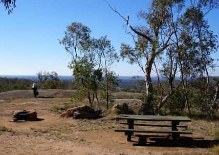
Swinging left onto the unsealed Tower Road, it is a little over a kilometre to the first of two picnic areas, this one being accessible via a left turn. This picnic area is set amongst the greenery, and does not have the views of the second picnic area; however it does have nice ambience.
The second picnic area is about another kilometre up Tower Road, and is on the left. This is the best of the crop, having amazing views of the floodplain to the north of the Ranges, nicely framed by a large granitic outcrop under your feet. There is a table and seating adjoining the car parking area, and this is another great place for morning tea or lunch.
Mount Killawarra
Diagonally opposite the entry to this picnic area, there is an unsignposted, gated track [AWTGS-3] that leads to Mount Killawarra. The summit of this noted peak is a little over a kilometre away, and presents a nice opportunity for some leg stretching and landscape photography.
Stepping around the locked gate, it is a short stroll to a cleared area where there is a water supply infrastructure for emergency usage. Continue past this area, and a reassuring signpost reads ’Mt Killawarra Track.
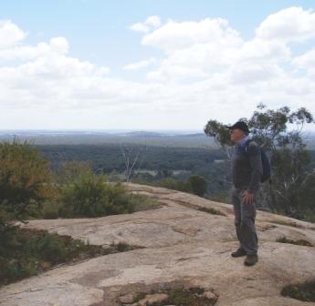
The track now starts to get more interesting, and winds around several hillslopes, with a gradual ascent to the rocky summit area of Mount Killawarra. On the way there are many different vegetation communities to take note of, as well as some excellent views of the surrounding floodplain.
Once at the summit, there is a survey trig to stand near, and some granite slabs to stand on and enjoy the expansive views. As Mount Killawarra is on the northern side of the Warby’s, the views extend out towards Mount Meg, Benalla and Yarrawonga.
Return to your vehicle by the same route, having spent about 40 minutes on foot.
Pangerang Lookout
Continuing the journey south, it is a short run to an unsignposted y-junction where you need to keep right (taking Ridge Road), with the tripmeter now recording something like 30km.
Ignore Link Track (going off to the left) and travel through to a sharp u-bend, where Ridge Road continues around to the left. At this point, Ferris Road veers off to the right, and this provides access to Pangerang Lookout.

There is a small car park just down Ferris Road, and from here it is an excellent undulating walk [AWTGS-3] to Pangarang Lookout, and some great views (the Pangarang People were amongst one of the earliest aboriginal people in the Wangaratta area). The signposted car park for the Lookout walk is quite small, and there are no facilities here.
However, having parked the hardware, the walk to the Lookout involves a loop of about 4.5km, and takes about 90 minutes to complete. Choose a nice sunny day, and enjoy the views, as well as that evocative blue haze that typifies the mid-latitudes right around planet earth.
Setting off from the car park, the track is quite sandy, and it is interesting to note the stunted tree growth, as well as the open nature of the woodland; all of this being a combination of poor soils and altitude. The track is quite undulating, but not demanding, and there are several glimpses of the surrounding countryside; expansive views to the right, and rocky gullies to the left.
The sandy soils soon give way to a more rocky terrain, with subtle changes in the vegetation as cypress pine becomes more evident, along with the bristle cone wattle.
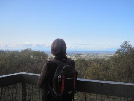
The final approach to the Lookout is heralded by some twists and turns of the track, and the Lookout then provides great views over the surrounding countryside.
Facing the signpost at this point, Wangaratta is to the hard left, Glenrowan soft left, the Strathbogie Ranges and the high country is straight-ahead, Benalla is soft right, and the Shepparton direction hard right. The views of Wangaratta and Glenrowan are blocked by a ridgeline, and Shepparton is too far away to actual pick out.
Wineries and Orchards
Returning the Ridge Road, and swinging right at the previously mentioned u-bend, it is a short distance to the bitumen, where a careful right turn is required.
The bitumen now leads downslope, with many great landscape views in front of you. A short run of about four kilometres leads to a poorly signposted intersection, where Boweya is to the right, Devenish and Thoona are straight-ahead and Glenrowan is to the left.
More about detouring to Thoona later, but for now, taking the Glenrowan option, it is a short run to Jones Road, with the left turn here leading to Mount Bruno Orchards (peaches and nectarines) and Cherrybrook Farm (cherries and olives; details at www.cherryfarm.com.au) and Judds Winery.
Back on the main route, Sayers Road comes up on the right, and marks the return of the optional detour to Thoona (details below).
Further south, Rowans Lane leads to Booth Road, with Auldstone and Booths Wineries being towards the end of this gravel roadway.
Just before Rowans Lane, the Lake Rowan Road goes off to the right, and can be used to make a detour to the Winton Wetlands; see the Benalla access route for more details.
Back on the bitumen, Taminick Gap Road (or Upper Taminick Road) leads to Baileys Winery, a great winery that offers rustic surrounds; much of the winery complex dates from the mid-1800s, and is very photogenic.
Mount Glenrowan [AWTGS-4]
Heading upslope from Baileys, follow the winding path of Taminick Gap Road as it climbs up one of the western faces of the Warby Range.
Once up on high ground, the walking track to Mount Glenrowan (Ridge Track) is to the right, being about 2.5km from Baileys, with a small picnic area being off to the left at the same place.
Mount Glenrowan is the highest point for many kilometres around, and was (reputedly) a haunt of the Kelly gang, and certainly offers an advantageous view of the surrounding landscape. The lookout near the summit was named Morgans Lookout, after a member of the Kelly Gang.
The walking track covers about 9.5km of interesting terrain, with the return trip taking up to three hours. The track is mostly undulating, however there is an initial steep section to gasp your way up.
Swing right just before the first telecommunications tower, and step it out on the gravel for the next 60 minutes to Mount Glenrowan and Morgans Lookout.
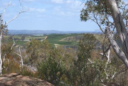
Views are excellent, with the Winton Wetlands (Lake Mokoan) being visible to the right on the outgoing section. This is followed by many nice views of the floodplain, way down below, with the mosaic caused by different land usages being quite noticeable.
Ignore all of the side tracks, and follow the main pathway of gravel all the way to the second telecommunications tower, and then walk around this structure to the right, to get to the main lookout area.
Expectedly, the views are really excellent, with Mount Buffalo being clearly visible, along with much of the northern side of the high country, as well as the township of Glenrowan, neatly laid out down below.
The geographical significance of the siting of Glenrowan is also apparent from up here, with the township clearly dominating a major gap in the ranges.
Sunrise Walking Track and Quarry
Continuing over the ridge, the route starts to make a descent back down to the valley floor, with many great views on the way of the Ovens-King floodplain on the descent.
The cross-roads at the intersection of Taminick Gap Road and Warby Range Road are encountered down on the flat ground, and a left turn here leads to the last but one main feature of this tour. Note that these cross-roads are an off-set junction, not a straight crossroads as shown on most maps of the area.
It is a short run on Warby Range Road to the signposted turn-off (Delloro Road, to the left) that leads to the Sunrise Walking Track Area - see the Warby Ovens National Park description for more details.
Staying on Warby Range Road, follow the bitumen for a bit over a kilometre, turning left at the off-set cross-roads at Shanley Street.
This leads to a narrow roadway that finishes at a very small car park, providing foot access to the scenic Salisbury Falls [AWTGS-3].
Having parked your vehicle, the signposted walking track leads north, passing a Warby-Ovens National Park sign, and a gateway.
Keeping left at the subsequent y-intersection, the footpath leads down slope to a small creek which needs to be crossed with care (great care when the creek is flowing well).
Continuing to take care as to where you place your feet, follow the footpath upstream, crossing over to the other side once more, and then further upstream for some great views of the Falls.
Return to the car park via the same route, and then when you get back to the off-set cross-roads referred to above, keep straight ahead, and this will take you down to the intersection of Shanley Street and Tone Road, with the city centre being to the left, Benalla to the right.
Starting the drive from Benalla
Starting the tour from Benalla involves a nice loop around the former Lake Mokoan (now the Winton Wetlands) and is a great entree to the Warbys.
The action starts by taking the old Hume Highway north from town, and then swinging left onto the Yarrawonga Road, about six kilometres from town. This leads to the north-west, and you need to keep right where the signage indicates that Yarrawonga is to the left (this is at a y-junction), and then taking the signposted Lake Mokoan Road to the right (this is about seven kilometres from the old Highway).
This leads onto a nice quiet bush road, with a series of rolling hills to the left, and great views to the high country over the wetlands to the right.
Continue along this road, and after about seven kilometres, there is a signposted entry gate to the left that leads to an expansive carpark, this being the main entry to the Winton Wetlands if you want to take a look at this feature.
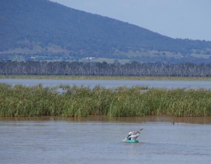
The Winton Wetlands were created out of what was formerly Lake Mokoan; however, prior to the creation of the Lake (in 1971), this was a wetland system, so things have gone full circle.
Aboriginal people once occupied the areas around the original wetland area, and would have found this to be close to an ideal environment for their hunter-gatherer life-style.
In 1971, the wetlands were flooded to create Lake Mokoan, an off-river irrigation storage for the waters of the Broken River, which rises to the north-east of Mansfield. In 2006 the Lake was decommissioned as a storage, and following this decision water, was no longer siphoned out of the River, and restoration of the original wetland habitat was commenced.
Continuing on from the Wetlands, the roadway maintains its course south of a hill system, with the much higher Warby Ranges now coming into view. Getting closer to the Ranges, a large y-junction is encountered where you need to veer right at the top of the y, and then keep right where you join up with the Glenrowan Road, and the main description.
Starting the drive from Glenrowan
To link in with the main text if you are staying in Glenrowan, cross over the railway bridge (via Beaconsfield Parade) from the centre of town, and then turn right at the t-junction. This is Warby Range Road, and from here it is an easy (and scenic) run to the Taminick Gap Road, where it is easy to pick up the main description. Note that some maps of this area have mislabeled the Old Hume Highway, placing it to the north of the railway, whereas it is to the south.
Starting from the southern side of Wangaratta
If you are starting the tour from the south side of Wangaratta, then you may want to keep access to the tour as simple as possible, and take the Old Hume Highway south from the CBD, and then swing right onto the Glenrowan Road, just before the Freeway on-ramp. This soon leads to the Taminick Gap Road, where you need to turn right, with Warby Range Road being about two kilometres away. Note that the turn-off from the Old Hume Highway is sign-posted ’Taminick’ not ’Glenrowan’.
OPTIONAL EXTRAS
Killawarra
An optional extra from the main part of the route takes in what was formerly known as Killawarra State Forest, but is now incorporated in to the National Park. The roadway that leads to Killawarra is an unsignposted slip road off to the north, and is about 200m east from where you turned onto Tower Road.
The first part of the slip road is not particularly smooth, but having driven 100m there is a signpost saying ’Camp Road’ and things are much better from here on.
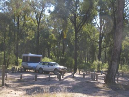
Turning left into Camp Road, it is a great run through open woodland, an ecosystem created by the dry conditions of the north-facing range country here. Ignore all of the minor roads and tracks leading off Camp Road, it is an easy 2.5km to ’The Camp’ (also known as Forest Camp) where there is some excellent camping infrastructure.
The Camp is a popular area, particularly with bird watchers, and given its great ambience, this is a nice place to spend a night or two.
Continuing on from The Camp (by taking Centre Road) it is an easy three kilometre run to where Centre Road becomes Schoolhouse Road, and (via some cleared pastoral land) this leads back to the Boweya Road.
Pine Gully [AWTGS-3]
Pine Gully Picnic Area is just to the east of where Ridge Track meets up with the bitumen (see main text) and comes up on the right after about a kilometre. This is one of the larger picnic areas in the Park, with plenty of tables of chairs, plenty of room to avoid the neighbours, and expansive views of the floodplain way down below.
Pine Gully Nature Walk, starting near the picnic area, is reasonably strenuous and takes about 90 minutes to complete, providing a good introduction to the ’look and feel’ of the Warby Ranges.
The track basically leads down to a waterfall (on Pine Gully Creek) and then back to the Picnic Area again, and is very scenic.
Intro Screen on a fresh browser page
COPYRIGHT © 1995-2020, Chris McLaughlin.