YACKANDANDAH
(www.northeastvictoria.online)
Yackandandah and the Valley of Gold offer many attractions to the visitor, the main one being ambience; this place oozes character all year round. A cold day in Yackandandah calls for hot soup around a friendly log fire at one of the hotels. If it’s summertime then it’s time to sit on the verandah of a cafe, and watch life go by. At any time of year it’s pleasant to absorb a bit of golden history.
Yackandandah first came on the map during the 1830s when pastoral leases were taken up in the area.
However things really started moving in the 1850s when gold fever gripped many parts of the North-east, including the Yackandandah area. Prior to this, the Jiatmathang People had occupied the Yackandandah area for several thousand years.
Explorers Hamilton Hume and William Hovell passed through the area in 1824, but the first settlers did not arrive until 1837. James Osborne and his family were amongst this first group of settlers, as was David Reid and family, as well as George Kinchington and his wife. Typical of the early settlement of North-east Victoria, all of these people came from the Sydney area.
Pastoralist David Reid (1820-1906) was the son of Surgeon-Lieutenant David Reid, a veteran of the Battle of Trafalgar, and in 1845, when excavating the water-race for a flour mill, discovered gold. Word soon got around, and the great Victorian gold rush was on in earnest, with prospectors swarming throughout the North-east and panning almost every stream for gold.
The population of the area grew rapidly as people of almost every nationality flocked to the goldfields. For example, Chinese miners entered the Victorian gold fields in force for the first time in the 1850s, and it was mostly Chinese labour that excavated the Yackandandah Gorge (see below).
Pastoral activities continued alongside the gold mining, and were to endure much longer than the bright metal activities, still forming an important part of the town’s economy.
The prosperity of the town was enhanced by the arrival of the Yackandandah railway, which linked Yackandandah to Beechworth, and therefore the Melbourne - Sydney Line via Wangaratta.
The line opened in 1891, and had an easy gradient to Wooragee, but from there to Yackandandah the terrain was steep, and trains heading into town would halt near the Yackandandah turnoff on the Beechworth-Wodonga Road, so that the guard could apply hand-brakes to the rolling stock. The line was closed in 1954, and although the track was removed, many sections of the path taken by the railway are still visible.
As well as some noted early settlers, Yackandandah was also home to Sir Isaac Isaacs. Isaacs was the first Australian-born Governor General, and lived in Yackandandah for a time; he was the son of a tailor and went to the Yackandandah School, where he was the first pupil to be registered; this was in 1864.
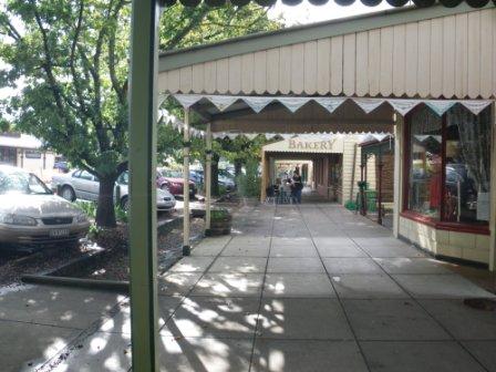
The main street of Yackandandah has survived the gold rush, and being a part of Sydney Road (the modern day Hume Freeway, long since re-routed and renamed); and despite all the noise and bustle that these things would entail, the whole streetscape is of great interest and beautifully preserved.
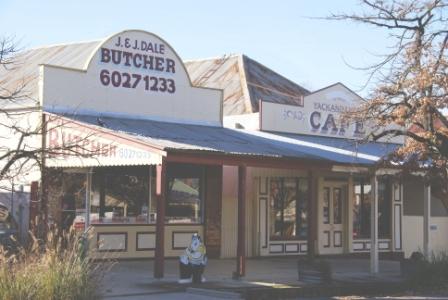
Expectedly, many of the town’s elegant buildings date from the gold mining era, and can easily be located during a casual stroll around town.
A sample of what’s on offer includes . . .
Anglican Church (Church Street, 1861)
ANZ Bank (originally the Bank of Australasia, High Street, 1877)
Ardsville (High Street, 1882)
Bank of Victoria (now a museum, High Street, 1865)
Catholic Church (Windham Street, 1861)
Court House (no longer used as a court, Railway Avenue, 1864)
Isaacs Villa (stone cottage on the corner of Isaacs Avenue and Williams Street, thought to have been the boyhood home of Sir Isaac Isaacs, early 1860s, very photogenic)
Melville House (Kars Street, 1870)
Post Office (High Street, 1863)
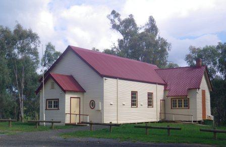
Public Hall (High Street, 1865)
Stone Bridge (Isaacs Avenue, formerly the main Melbourne - Sydney Road, 1857)
The Athenaeum (High Street, 1878)
Yackandandah Hotel (corner High and Williams Streets, 1878)
As mentioned, all of these places can be found on a stroll around town, and this is an excellent way to spend a morning or afternoon. The Visitor Information Centre (VIC, in High Street) has a brochure called A Walk in High Street that will help you find your way around the main part of town, with historical notes on most of the significant buildings.
Finding a good place to eat is no problem in Yackandandah, as well as the hotels, there are several cafes, and if you prefer an outdoor setting then the Soldier's Memorial Park (corner High and Wellsford Streets) and Isaacs Park (Wodonga Road) offers the best in picnic venues.
Other things to see and do around town include . . .
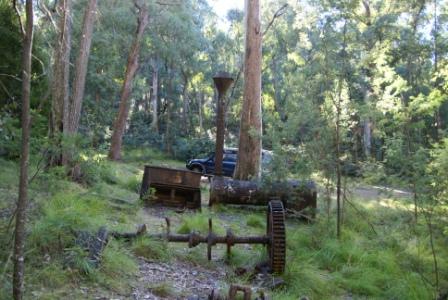
Karrs Reef Gold Mine
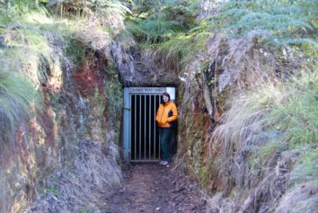
A short drive out of town on forest roads leads to the historic Karrs Reef Goldmine, and an interesting part of Yackandandah’s history. You can drive out to Karrs Reef by yourself, however to go inside the mine it is necessary to take an escorted tour; see the VIC for more details. Please note that this is currently a 4wd access only route, unless you want to walk the last kilometre or so.
If you are doing your own thing, make sure that you take care in this area, as there are many diggings from the gold mining era. See Staying Safe in the Australian Bush : A Travellers Guide (published by Rosella Publications; author Andrew Monroe) for some relevant safety information regarding old mine sites.
Note that we could not find any current map that accurately depicted all of the roadways that we have documented here; follow our notes carefully!
Setting off from town, you need to take Twist Creek Road, a left turn (when heading out of town) from the Beechworth side of the town centre. Once clear of the urban area, the bitumen is left behind, and there is a run of about four kilometres to a sweeping left turn near a farm. Here you need to avoid Bullocky Creek Track (which goes off to the hard left) staying with the main run of gravel.
This soon leads to another intersection, where Boomerang Track goes off to the left (Twist Creek Road continues on from here, but this is a far as you need go on this roadway).
If you have a 4wd vehicle, with reasonable ground clearance, you can now set off down the narrow (and rutted) Boomerang Track, with the final access track to Karrs Reef Mine being a right turn 6.3km from where you first turned onto Twist Creek Road.
For the technical people, this is at GPS 36.19.50s : 146.47.10e.
If you do not have a 4wd vehicle, or feel like a walk anyway, it is about a kilometre to the mine site from Twist Creek Road.
Once having parked the vehicle, it is interesting to wander around and have a look at several relics from the mining era, all of them quite photogenic as they lie in this remote part of the forest.
As mentioned, a tour operator in Yackandandah offers guided tours of the actual mine (which is underground) but for now, you can admire the hefty subterranean gate that keeps the mine secure.
An alternative access route is to swing hard left onto Bullocky Creek Track (referred to above) and follow this to an unsignposted track to the right. This is the other end of Boomerang Track, and this can be followed to the final access track, as referred to previously.
As with the other access route, do not enter Boomerang Track unless you have a 4wd vehicle; and (as before) without a 4wd, you now have a walk of about a kilometre in front of you.
Osbournes Flat Tour
This interesting drive encompasses much of the history of the Yackandandah area, and takes about two hours to complete, depending on your interests.
From near the centre of town, take the Myrtleford - Dederang Road from the eastern end of High Street. This leads down to Yackandandah Creek, and then back up the hill, meeting up with the Osbournes Flat Road, going off to the left after about 2.5km. Osbournes Flat Road basically follows Yackandandah Creek downstream, and it is the Creek, and its association with gold mining that makes this drive so interesting.
Turning left onto Osbournes Flat Road, it is a few kilometres to a locality known as Rowdy Flat. This was one of several gold mining areas along the Creek, and the name says it all; in modern parlance, this place was not user-friendly.
The first hanging at the newly constructed Beechworth Gaol handed out retribution to a murderous gold digger from Rowdy Flat, and the place never quietened down until the gold ran out. An information board at the Rowdy Flat crossroads has more details on the settlement, and its colourful history.
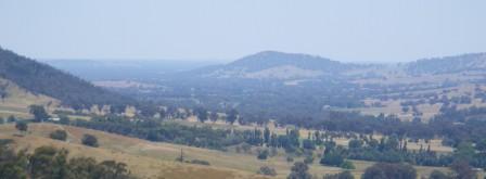
Continuing on from Rowdy Flat, there are excellent views to be enjoyed, particularly those of the Kiewa Valley, and the high country (to the right). Nearby peaks include Mount Big Ben (1166m) and Mount Murramurranbong (883m).
Osbournes Flat itself is about 5.5km from Yackandandah, with another information board outlining the history of this area. The board is on the right of the roadway and is not too easy to spot, being just beyond the Racecourse Road turn-off.
Osbournes Flat was named after James Osbourne, a squatter from the pre-gold rush period, James having settled here in 1837. Within 20 years, the Flat was home to numerous hotels, brothels and assay offices, giving James quite a culture shock.
The Vienna Patisserie is on the right, at about 11km from town, and is a good place to visit if you feel like some decadence. The Patisserie has a small car parking area which is not really suited to trailers, caravans and motorhomes.
A few hundred metres beyond the distinctive architecture of the Patisserie, Allans Flat Strawberry Winery is on the right, and offers almost everything that can be made from strawberries; a popular venue.
Just beyond the Winery, there is an artificial lake visible to the right; this is the site of the original Allans Flat settlement, with the lake being the now flooded alluvial gold mining area.
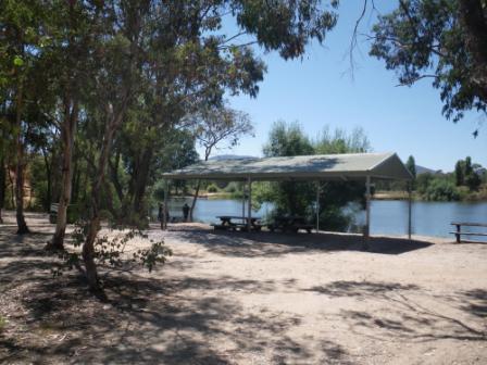
This is a popular fishing, paddling and swimming venue that manages to keep most of its water, even in the longest of droughts. Take care if you go swimming here; this is deep, and mostly cool, water - a nice venue for strong swimmers, but not the average.
Access to the Lake is via the signposted Allans Flat Reserve gateways, the first of these being immediately on the right, after the Strawberry Winery.
Just before the gateway, there is a stone memorial cairn to David Reid, and his family, who first settled the Allans Flat area in 1845, with gold being discovered a few years later.
The ’gold digger’ era ran from the 1850s through to the 1890s, when the big alluvial gold mining operations began, finally petering out in 1904.
Further down the roadway, there is a nice car parking area (on the right, overlooking the lake) has an information board that provides some of the details about those early years, and this is a great spot to admire some views of the natural, and man-made, world.
Not far around the corner, there is another formal roadway leading to the lakeshores, with picnic areas and a toilet block being provided.
Back on the bitumen, and continuing north for a short distance, the C527 t-junction has Yackandandah sign-posted as being about eight kilometres to the left, and this brings you into town via Isaacs Avenue, and the historic stone bridge over Commissioners Creek.
Short Walks
There are several easy short walks in, and around the township. The VIC website (see link below) has a downloadable sketch map of the walks described here (as well as others in the area) and is a handy asset to get hold of prior to setting off.
Lions Walk: This enjoyable walk takes about 20 minutes to complete, starting out from Isaacs Park. The track parallels Isaacs Avenue and takes you past a replica of a miner’s cabin, as well as the historic courthouse. There is adequate parking at either end of this linear park, and you can either park in Williams Street, or near the corner of Railway Avenue and Isaacs Avenue.
Mineral Springs: This short walk (AWTGS-2) also takes about 20 minutes, and heads north from the centre of town, and leads to a small spring on Commissioners Creek.
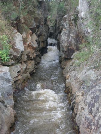
Yackandandah Creek Gorge [AWTGS-3]
Yackandandah Creek is a tributary of the Kiewa River, and therefore the Murray River; it rises in hill country to the south of the township and rarely runs dry. The so-called Gorge of Yackandandah Creek is just upstream of the urban area, and is a reminder of the gold rush years, the Gorge having being cut (and blasted) through bedrock in the 1850s to provide sluicing water for mining operations.
There are two ways to access the gorge, on foot, and by car.
The pedestrian option involves heading for the ‘Sports Park’ at the downhill end of Wellsford Street; you can do this by driving, as well as on foot, as the Park is not far from the town centre (Wellsford Street runs directly off High Street).
Having crossed over the bridge over Yackandandah Creek, you need to swing right, and make your way past all of the sporting facilities, basically following the Creek upstream.
This soon leads to the area where the Creek appears to be cutting its way through the bedrock, but as mentioned, this is not entirely natural.
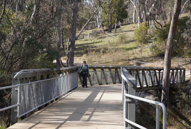
Having admired the lower part of the Gorge, you can follow a walking track upstream, crossing over a small pedestrian bridge, and continuing up the other back for about a kilometre.
The walk takes about 90 minutes to complete, depending on your interests. The VIC website (see link below) has a downloadable sketch map of the walk described here (as well as others in the area) and is a handy asset to get hold of prior to setting off.
By car, you need to take Bells Flat Road, a left turn (when heading out of town) from just on the Beechworth side of the town centre. Once clear of the urban area, the bitumen is left behind, and there is a short run to a small car parking area on the left.
This leads to the core section of the Gorge, with a short walk upstream and downstream providing plenty of interest and photographic opportunities.
Yackandandah to Osbournes Flat
This is a 6.5km sealed walking/cycling route, and starts from near the centre of town, leading towards the nearby village of Osbournes Flat.
The walk starts at the bridge over Yackandandah Creek (on Wellsford Road), within easy walking distance from the centre of town.
The pathway follows an undulating route close to Yackandandah Creek, with several pedestrian bridges to cross, and plenty of rocky outcrops to admire in the creek.
Once at the bitumen of the Osbournes Flat Road, it's time to turn around, and follow the pathway back to Yackandandah.
Walking time (for the complete there-and-back walk) is about five hours, but it's easy to shorten this by turning around at any point.
Points of interest along the way include great scenery, plenty of birdlife, revegetated relics from the gold mining era, and several mini wetlands.
There is a toilet block at Osbournes Flat, and an enjoyable picnic area (with gazebo) about 800m before the village.
Access to Yackandandah
There are several options for accessing Yackandandah, all of them quite interesting. One of the easiest routes is to take the Hume Freeway to the Barnawartha - Yackandandah exit, and head east from here, passing through the scenic Indigo Valley en route to Yackandandah.
Watchbox Creek is crossed after about 16km; early settlers identified a granite knoll as the site for ’the watchbox’, a place where the stockmen from the Eldorado Run could watch over their stock grazing the Indigo and Black Dog Creek Valleys in the early 1800s
Continuing on, it is now a short run to a t-junction with the C315 (the Wodonga - Beechworth Road) where a careful right turn is required. A little over a kilometre later, the C532 comes up on the left, and you need to make a sharp left at this point, swinging past an expansive road side rest area.
This rest area was once a part of the Beechworth - Yackandandah railway route, and was a shunting yard. In more recent times, a tunnel has been created under this intersection, part of the preparation for the soon-to-be Beechworth-Yackandandah Rail Trail.
Yackandandah is now about five kilometres away, and it is a scenic final run into the township, with several cuttings from the railway being visible to the left as you approach town.
Yackandandah Visitor Information Centre
Intro Screen on a fresh browser page
COPYRIGHT © 1995-2025, Chris McLaughlin.