YARRAWONGA - MULWALA
(www.northeastvictoria.online)
The Pangerang People were the original inhabitants of what is now the Yarrawonga-Mulwala area, but this long-standing era was to be changed by the gradual European exploration, and settlement, of North-east Victoria.
The early exploration of the North-East by Europeans began in 1824, with an expedition which set off to determine whether any navigable rivers flowed south from the Goulburn Plains of New South Wales, towards the Port Phillip District. In charge of this expedition was Hamilton Hume, after whom the present day Hume Freeway is named.
The explorer’s route followed the western foothills of the New South Wales High Country, forded the Murray River upstream of the Kiewa River confluence, and then in turn the Kiewa, Ovens and King Rivers.
Following on from the Hume and Hovell Expedition, as well as exploration by Major Mitchell, Hamilton Hume helped his sister-in-law (Elizabeth Hume) select the property which became known as Yarrawonga Station.
The township of Yarrawonga was subsequently founded in 1868, and for many years was a riverboat port, with paddle steamers plying their way as far upstream as Albury. The advent of the railways scuttled the riverboat trade, but the township continued to prosper.
Punts operated across the Murray at Yarrawonga until the first bridge was built in 1890, and this wooden structure survived until 1917 when construction of a more modern bridge began.
The old bridge was a busy place for bureaucrats, as the Colonies of Victoria and New South Wales both imposed customs duties on goods moving across the border. However, this was all to end with Federation.
In 1933 a proposal was made to build an irrigation weir at Yarrawonga, and the lake created by this large structure first started to fill in August of 1939, construction having started in 1935. The weir at Yarrawonga is the largest of the sixteen weirs on the Murray River, and allows gravitational flow of water to large areas of northern Victoria, and southern New South Wales. The Weir is part of a complex irrigation system consisting of four major storages, sixteen regulating weirs and five barrages.
Yarrawonga’s attractions include an enjoyable lakeside rural atmosphere, good shopping and, of course, boat tours on the lake. Downstream of the town there are extensive areas of red gum forest along the Murray River, with easy access and many recreational opportunities, particularly for canoeing, fishing and camping.
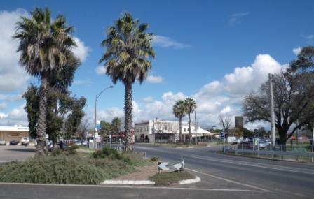
The main streetscape (Belmore Street) is quite interesting, as it is home to many great examples of commercial architecture from the art-deco period. All of these can be detected by walking up and down the main shopping area, and taking note of the upper facades of many of those modern shop fronts.
Byramine Homestead
Byramine Homestead is a National Trust classified property that is open to visitors, and is a short distance to the west of town (an easy drive on the Murray Valley Highway). Attractions include a piece of history (the Homestead was built in 1842 for Elizabeth Hume), some nostalgia, a produce store and an excellent cafe.
Elizabeth was the wife of John Hume, brother of the noted explorer Hamilton Hume. John was shot dead by members of the Whitton bushranger gang in 1840, and Hamilton then took on the responsibility of looking after his newly widowed sister-in-law.
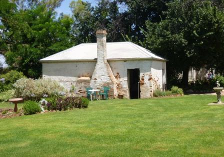
As part of this process, Hamilton assisted Elizabeth in establishing a pastoral run, which was to be called Yarrawonga Station, a title that would soon be passed to the new township of Yarrawonga.
Elizabeth’s design plans for the Homestead incorporated the site of the main building, its orientation and an unusual octagon shaped central room (which includes an expansive cellar, and is known as The Fortress) to be used to provide a central panic room in case of attack by bushrangers or aborigines.
In the absence of modern day amenities such as air conditioning, the walls of the Homestead are about 40cm thick, and were kiln baked on-site. The fine timber from local Murray Valley Pine woodlands were harvested for much of the framework of the homestead, as well as the furniture inside it.
Once completed, Elizabeth named her new home Byramine (rustic retreat) and in keeping with this theme, she created an ornamental garden around the Homestead, much of which survives to the present day.
As well as the cafe, the modern day property has a large market gardening operation, and amongst the items on sale at the produce store is a nice array of locally grown vegetables.
See the Homestead’s website (link below) for opening times.
Chinamans Island
Chinamans Island is actually a promontory, and can be found just east of the centre of Yarrawonga. The Island has had a varied career; many years ago it was used by local aborigines to hunt for food (kangaroos and wallabies) as well as to gather seeds and fruit from riverine vegetation.
In the early European era, it was used as a market gardening area, with most of the action being undertaken by Chinese immigrants. As the town of Yarrawonga expanded, the market gardening fell away, and for many years the Island languished.
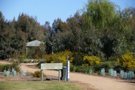
A proposal to build a large casino on the Island galvanised the locals to do something better with this asset, and the area has now been rehabilitated, with several walking tracks and picnic areas to enjoy.
Access is easy, being achieved by taking River Road, from the eastern side of the town centre to the Yacht Club.
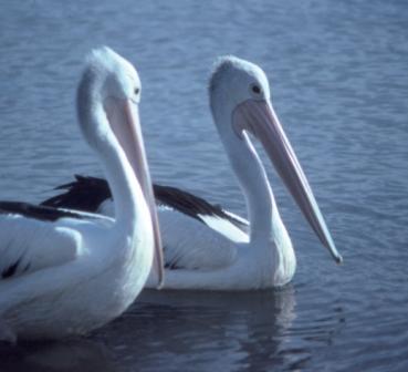
From the Yacht Club (where there is a reasonable amount of car parking space) keep heading east (away from town) and follow the walking track through to a formal picnic area (with rotunda) where you can swing left, and follow the nice and easy walking track through to Aitchisons Point and Wrights Lookout, both of which are on Chinamans Island. As you walk out to the Island, there is an extensive area of wetland to your left, and this is a good area for bird watching.
Alternative access to the Chinamans Island area is from the Rowing Club, which can be accessed via the Murray Valley Highway, and then Botts Road, from just west of the urban area. In any case, the Visitor Information Centre has a handy brochure with all the necessary details.
Best of all, from the town centre, follow the lakeside walking path all the way to the Island, this takes about 40 minutes, with the option of continuing on to the Sebel Silverwoods Hotel, a total of about 60 minutes from the town centre.
The Sunset Bar at the Hotel is a great place to enjoy the lakeside scenery, and the adjoining restaurant (Elizabeth’s) serves a great meal.
Gorman Park, Mulwala
On the NSW side of the Murray, Gorman Park has a small network of very enjoyable walking tracks, and is accessible via a sign-posted turn-off on Golf Club Road.
The access road is unsealed, but well graded, and this leads to a spacious car parking area, and a map of the Park.
The Park is quite popular with joggers, and bird watchers, and is a great place for a stroll of upto about five kilometres.
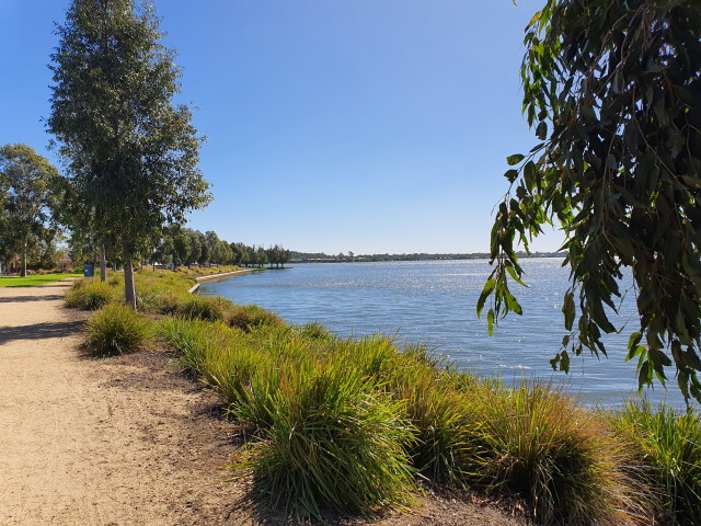
Lake Mulwala
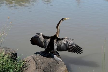
As well as being the major geographic feature of Yarrawonga-Mulwala, Lake Mulwala is an interesting boating venue. The backwaters of the Lake are littered with dead trees, islands and reed beds and this attracts enormous numbers of water birds, particularly in the Thompsons Island and Gull Island area.
Spatial Vision’s Murray River Access (Albury - Wodonga - Howlong - Wahgunyah - Rutherglen - Yarrawonga - Mulwala) provides a good overview of the Lake, and its immediate environs, and it is worthwhile getting a copy of this map if you intend to do any serious boating on the Lake. The ability to swim, adequate boating safety gear and safety precautions are also a necessary part of your kit.
Several tour operators run tourist cruises on the Lake, and these are an indispensable part of any serious visit to Yarrawonga-Mulwala (the Visitor Information Centre has all the details; see below).
If you want to organise your own boating expedition . . .
On the Victorian side there are several easy access points. The township of Bundalong is just downstream of the Ovens River confluence (at the upstream end of the Lake), and has several boat ramps, including one at the confluence itself. On the way to Yarrawonga from Bundalong there are several ramps; Wrights Road is 10km east of Yarrawonga, followed by Boomanoomah Road at seven kilometres, and finally, Hogans Road (at Woodlands) is three kilometres east of Yarrawonga.
In Yarrawonga itself, there is easy boat launching near the Rowing Club, the Yacht Club and alongside Bank Street.
On the New South Wales side there are several convenient locations for disembarking and launching, and the Corowa Road in fact follows the northern (NSW) lake shore for about 18km. This provides vehicular access to several easy launching points onto the Lake, and subsequently, the Murray itself. These are nice areas for launching if you just want a day trip from the backwaters of the Lake back into town.
Examples include Apex Park, Purtle Reserve, Owen Bridges Reserve and Kyfinn Reserve (with its expansive camping area); these venues being 1.8km, 2.1km, 3.8km and 6.4km respectively from Yarrawonga via the Corowa Road.
Much further upstream, Collendina State Forest has several nice places to set up camp, or set off downstream from, all of them being dry weather access only. See the Spatial Vision Map for more details, and note that some of these access points lead into ana-branch systems, and not the main channel of the river; you may need to paddle for a couple of kilometres to get to the Murray proper.
As well, Lake Mulwala Caravan Park and Mulwala Shoreline Caravan Park both have direct access to the lake’s waters, and are located about 0.7km and 2.2km from Yarrawonga respectively, on the Corowa Road.
Further east, Lake Mulwala Holiday Park is similarly endowed, and can be found a little over eight kilometres along the same road, just on the eastern side of Kyffin Reserve.
Yarrawonga Visitor Information Centre
Intro Screen on a fresh browser page
COPYRIGHT © 1995-2020, Chris McLaughlin.