BEECHWORTH
(www.northeastvictoria.online)
The gold era brought prosperity to many areas of the North-east, and an almost insatiable demand for social infrastructure. These two factors combined to produce an enviable collection of goldfields towns typified by the fascinating township of Beechworth. The township is a magnificent example of a prosperous nineteenth century administration centre; it is all there to see, from government buildings, to hotels and public works.
For many years, Beechworth was the major town of the North-east, but gradually gave up this position to Wangaratta. Once it had been decided to build the Melbourne – Sydney Railway down on the flood plain, rather than across the hill country where Beechworth is located, it was inevitable that Wangaratta would gain some prosperity at the expense of Beechworth.
However, in the late 1960s steps were taken to preserve and renovate the historical areas of the town, with particular emphasis on preserving the shop frontages, which form such a major part of the streetscape. This led to the restoration of many fine buildings, and the subsequent rejuvenation of the township altogether.
One of the main drawcards of present day Beechworth is its beautifully preserved streetscape. Not only is it beautiful, but it still works. Many successful businesses still carry on their day to day work in an aesthetically pleasing nineteenth century building.
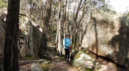
One of the best ways to fully appreciate many of these fine buildings is to walk around town so as to get a good look at the streetscape, and to get an insight into what the township must have been like in those golden years.
Some of the notable buildings around town, include (in alphabetical order) . . .
Bank of Australasia (Ford Street, 1858)
Bank of Victoria (Rock Cavern - Camp Street, 1867)
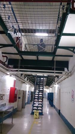
Beechworth Gaol (Ford Street, 1860)
Chinese Burning Towers (Balaclava Road, 1856)
Church of England (Church Street, 1858)
Hibernian Hotel (Camp Street, 1876)
Library and Burke Museum (Ford Street, 1856)
London Tavern (Camp Street, 1859)
Mental Hospital (off Albert Road, 1867)
Newtown Bridge (Ford Street/Wangaratta Road, 1874)
Old Hospital facade (Church Street, 1856)
Powder Magazine (Skidmore Road, 1859)
St Josephs Church (Church Street, 1868)
Tanswells Hotel (Ford Street, 1873)
It is worthwhile getting a copy of the Self Guided Walking Tour brochure from the VIC, and devising a walking route to suit your interests. Whatever route you take it will be a walk through history.
Beechworth Heritage Trail
This walk starts and finishes in Victoria Park, off Ford Street, and encompasses some natural features, as well as the human history of Beechworth.
Victoria Park is a left turn as you enter Beechworth from Yackandandah, or a right turn, just past the Gaol, as you head out of town towards Yackandandah.
A small car park, at the entrance to Victoria Park, provides a convenient place to park in the shade of some handsome conifers. From the car park, set off up the hill along a well-surfaced walking track. This leads to the top of The Rock, a great vantage point from which to view some of landmarks of the town.
A plaque on The Rock commemorates the death of Queen Victoria in 1901. Once over The Rock, the walking track descends to High Street and, a short distance to the left, Junction Road.
Turn right at Junction Road, and stroll along the shores of Lake Sambell. This is an artificial lake, formed by flooding old gold diggings. McConville Avenue follows the northern lakeshore fairly closely, wandering amongst pine trees with several different views of the lake.
At the end of McConville Avenue turn right into Albert Road (Camp Street) and follow this to its junction with Ford Street, the main commercial thoroughfare of Beechworth.
Albert Road has many noteworthy individual buildings, however it is the overall streetscape that is the most striking feature of this part of Beechworth.
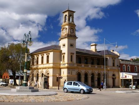
Once at Ford Street, turn right after the Post Office (1869). Buildings of interest on the left-hand side of the street are the Bank of New South Wales (1858) and the Shire Hall with Ned Kelly’s Cell. The Burke Museum (at the rear of the Shire Hall) is well worth a visit, having detailed exhibits covering the Kellys and, of course, explorer Robert O’Hara Burke.
On the opposite side of the street there is a row of sandstone buildings dating from the 1850s.
Where Ford Street veers off to the left, cut across the Town Hall Gardens, picking up Williams Street which leads to the historic MB Cellars (previously Billsons Brewery, 1865) at the corner of Williams and Last Street.
Continuing along Last Street, turn right into Kars Street which brings you back into Ford Street, near the entrance to Victoria Park.
After the walk it is time for some rewards at one of the many excellent cafes in town.
Other items of interest in, and around, Beechworth include . . .
Burke Museum
The Burke Museum (named after the explorer) also has many items of interest from the bushranging era, and just a little way up the street you can enjoy a relaxing drink (and an excellent meal) at Tanswells Commercial Hotel, apparently a favourite haunt of the Kelly Gang.
Kelly Cell
The Kelly Cell can be viewed at the rear of the Shire Hall (Ford Street). The Kelly Cell is also linked to the activities of Harry Power, but whichever version of local history you subscribe to, this is still an interesting place to visit.
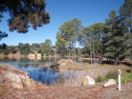
Lake Kerferd Walking Track [AWTGS-2]
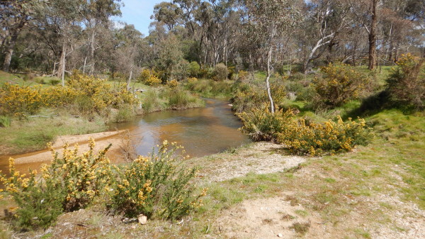
This 11km track starts at the picnic area on the northern corner of Lake Sambell. It follows Hurdle Creek fairly closely to Lake Kerferd, returning by the same route, and is very enjoyable, and very scenic (excellent forest scenery). Allow at least three hours for the complete walk (that is 5.5km there, and 5.5km on the return).
The Lake forms a major part of Beechworth’s water supply, and was named after prominent local George Kerferd who first advocated this site. The dam was declared operational in 1874, and Kerferd went on to become mayor of Beechworth three times, a member of the Victorian Parliament for many years, and subsequently Premier of Victoria in 1874.
As well as ensuring that his home town established a secure water supply, Kerferd was also to ensure that Beechworth got a railway connection to the main Melbourne - Sydney Line.
A brochure describing this walk is available from the Visitor Information Centre, and there is plenty of signage on the track.
[This pathway is now part of the newly opened Indigo Epic Trail, a 56km mountain bike trail that links the towns of Beechworth and Yackandandah.]
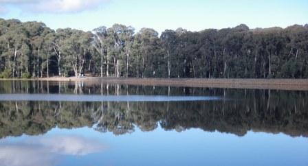
Lake Sambell
Lake Sambell is close to the centre of Beechworth and is a very enjoyable venue.
The Lake is actually the flooded site of abandoned gold diggings, and evidence of the gold mining era is still apparent around the shoreline.
The Lake is very popular with canoeists and swimmers on a hot day, and there are picnic and barbeque facilities at the northern edge of the Lake, with plenty of shade, and some car parking. The nearby Lake Sambell Caravan Park has all facilities, and is a great place to stay.
As well as water based activities, there is additional entertainment in the form of a walking track {AWTGS-3] which winds around the Lake, giving great views of the township and Lake.
The walking track has been renovated in recent times, and now follows the shoreline quite closely, with several information boards detailing the history of the Lake, and its ongoing management.
For bird watchers, there is a bird hide, on the eastern shoreline, not far from the Caravan Park.
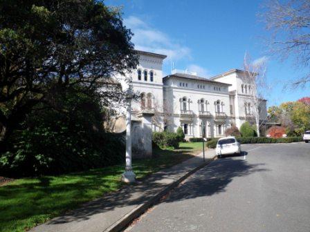
Mayday Hills
The MayDay Hills complex was formerly known as the Lunatic Asylum, and dates back to the late 1860s, when the first buildings were constructed, and the initial plantings of the excellent gardens took place.
The buildings, and gardens were added to over time, and so several different architectural styles can be seen, as well as the impact of different garden design themes.
All of this makes for a pleasant morning, or afternoon, of rambling, and there are three nicely documented walks to be completed within the grounds. These are all detailed in the brochure entitled Beechworth Tree Walks, available from the Beechworth Visitor Centre.
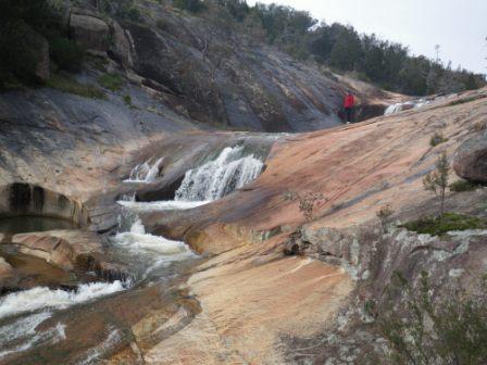
Woolshed Falls
Woolshed Falls (on Reedy Creek) are near the site of the former Reids Creek Goldfields, and both the Falls, and the goldfields, are now included within Beechworth Historic Park. The turn-off (McFeeters Road) to the Falls is clearly signposted about four kilometres from Beechworth on the Chiltern Road, and this makes a pleasant half-day outing from Beechworth.
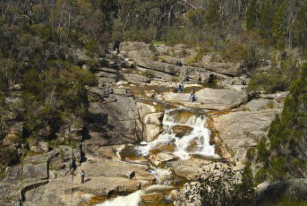
The turn-off leads (after about 1.5km) to a right turn signposted Woolshed Falls, and from here it is a short drive to the carpark that adjoins the Falls Picnic Area.
The Falls are clearly visible from several vantage points around the Picnic Area, and there are some short trails that lead to various parts of this scenic cascade.
Many items of human and natural history can be found in this area, for example the water diversion works, and water races associated with gold mining. These and other items of interest can be found on the walking trail.
The Falls are at their most spectacular in springtime, particularly if the creek is running high and the wattles are in bloom (an interesting combination of browns and yellows).
This is a popular venue on weekends, and in holiday periods, particularly in spring and summer.
Woolshed Falls - Spring Creek Cascades
If you are an experienced bushwalker (and the day is not too warm) there is a 4.2km walking track [AWTGS-3], that leads from Woolshed Falls to the Spring Creek Cascade.
Once at the Falls carpark, there are picinc amenities, as well as a toilet block, and this is a nice place to have morning tea before starting the walk.
The walking track basically follows Spring Creek upstream, with many items of interest from the natural world, as well as gold mining history.
Having arrived at Ponds Track, turn right, and then left at the sign-posted track, and follow this uphill to one of several vantage points of the Cascades (great place for lunch).
Returning via the same route, the overall distance is about 9km, assuming that you have a look at the Falls from the Viewpoint, and from closer to the valley floor; the overall walking time is about three hours.
A good pair of walking shoes/boots are essential, and many will find a set of trekking poles a useful asset. In sustained wet weather, boots are a better choice than shoes, as there are some boggy sections.
[The walk can be completed in the opposite direction, starting out from just west of the Spring Creek Bridge on the Scenic Drive (see below), however there is not much car parking space at this point.
The walk is sign-posted off the Scenic Drive, and heads downslope, and to the left, ready for a steep descent down to the Creek, with great views of the Cascades to the right.
Once at Ponds Track, turn right, and then left at the sign-post.]
Spring Creek Gorge Scenic Drive
Spring Creek was a bustling place in the mid 1850s when it supported a large population of gold diggers. Things are much more tranquil today, and this description highlights many human and natural features of interest.

There are also several signposted walking tracks that lead off from the roadway, taking you to several of the notable features of the area; a copy of the Beechworth Historic Park brochure (available as a PDF, see link below) will help you enjoy each of these options.
The unusual trees along most of the drive are black cypress pines; these native pines thrive among the dry granite outcrops which characterise the Beechworth area.
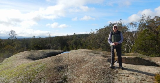
Ingrams Rock: This is a local landmark and lookout, well known for its panoramic views of granite studded woodlands. The Rock is a good place for a scramble (take care – steep in sections) and was named after James Ingram, a former Beechworth citizen. Access is via the Old Chiltern Road from near the Chinese Burning Towers.
One Tree Hill : Retrace your route slightly from Ingrams Rock to pick up this next item of interest. During the gold era many thousands of trees in the Beechworth area were logged, mostly to provide timber for mine shafts but also for firewood. As expected, this landmark takes its name from a survivor of those early days.
Kelly Country Vista : This is a huge slab of sloping granite which leads to great views. Park your vehicle on the opposite side of the track to the slab and enjoy the rugged landscape that was said to be the scene of many exploits and intrigues of the Kelly Gang.
Powder Magazine : The Powder Magazine was built in 1859-60 to store the large amounts of gunpowder used in mining deep alluvial and quartz gold deposits. This solid looking structure stands on a granite outcrop and has a pitched slate roof and porch style entrance.
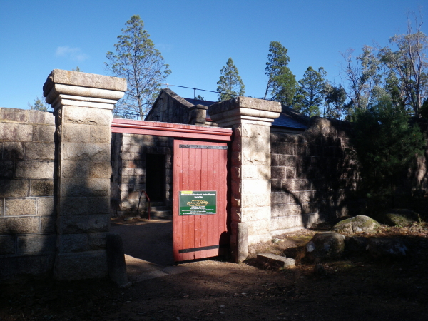
A stone capped outer wall, ending in hefty pillars and solid gates, was added in 1860. If an explosion occurred, the design of the building, with its arched inner roof and foundations, would have (in theory) ensured that the blast went upwards, causing minimal damage to the immediate surroundings.
After a long period of neglect, the Powder Magazine has been restored and is now managed by the National Trust and open for inspection most days of the year.
Just before crossing Spring Creek there is an interesting area where large outcrops of intrusive granite have been exposed by the erosion of overlying softer rocks, a good place for photography.
Granite Tors : Just before crossing Spring Creek there is an interesting area where large outcrops of intrusive granite have been exposed by the erosion of overlying softer rocks, a good place for photography.
Spring Creek Bridge : Around the corner, Spring Creek Bridge comes into view, as well as some spectacular rock pools, both upstream and downstream of the Bridge. A signposted walking detour can be found just over the Bridge, and this leads downstream to some very photogenic cascades. The views are great, but the terrain is not particularly friendly, and is not recommended for inexperienced walkers.
Rocky Mountain Tunnel : On the opposite side of the creek from the Bridge, there are some willow trees which hide an old tunnel entrance. The Rocky Mountain Extended Mining Company mined for gold in the Lake Sambell area from 1856, and sluicing was used to wash away alluvium and expose the gold-bearing material.
The tunnel was constructed to reduce the water level in nearby Spring Creek and thereby expose new areas for sluicing. Running for 800m right under Beechworth township, it took about two and half years to complete.
Newtown Bridge : Continuing onwards (and upwards), the Newtown Bridge comes into view. This lasting structure was completed by Scottish stone masons in 1875 to replace a wooden bridge which was slightly upstream of the present structure. A large water-powered mill once stood at the head of the falls (just downstream of the bridge), supplying the town with locally grown and ground wheat.
Having reached the end of the drive/walk, the town centre is a few minutes away (to the left when you meet up with the Wangaratta Road). Getting to the town centre involves crossing Newtown Bridge, and just beyond this structure there is a memorial obelisk that commemorates the discovery of gold in this area in 1852.
Ingrams Rock Walk [AWTGS-3]
This eight kilometre (four hour) adventure requires formal walking shoes/boots, a set of trekking poles, and dry conditions.
A copy of the Beechworth Historic Park brochure (available as a PDF, see link below) is also required.
This very scenic, and interesting, walk starts from the Powder Magazine car parking area. From here, take the signposted walking track that lead off from the roadway, just near the walk information gazebo.
The track (which is mostly single file), leads upwards from the car parking area, and the first item of note is a split in the track after a short distance; keep left at this point, and then continue, mostly downhill, to another intersection.
Swing right at this point, and follow the track (mostly upwards) to One Tree Hill.
This was named during the mining era for obvious reasons, but has a lot more vegetation in the present era. The views are excellent, and continuing on from here, the walking track meets up with a roadway (One Tree Track) where you need to swing left, having read the signpost regarding distances.
Continue to follow the directions towards Ingrams Rock, where there are some really excellent views, but take care if clambering on the Rock as it is slippery at all times.
From Ingram's return on the incoming route for a short distance, so as to pick up the sign-posted track to Fiddes Quarry.
Continuing west from the Quarry, follow the narrow footpad to The Precipice, where there is a small viewing platform.
The Spring Creek footbridge is out of action, and when you arrive at The Precipice there is a sign indicating this.
At this point, take the slip track that leads from The Precipice back up to the main track, 300m south of Ingrams Rock; turn right here, and return to the start via One Tree Hill.
BEECHWORTH (via Eldorado and Woolshed Valley)
Beechworth Visitor Information Centre
Intro Screen on a fresh browser page
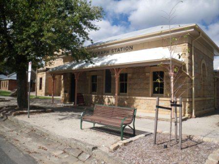
BEECHWORTH to YACKANDANDAH RAIL TRAIL
COPYRIGHT © 1995-2024, Chris McLaughlin.