BEECHWORTH
(via ELDORADO and WOOLSHED FALLS)
(www.northeastvictoria.online)
TRAVELLING TIME: About 1.5 hours.
DISTANCE COVERED: About 50km.
OVERVIEW MAPS: Rooftop Maps, Beechworth - Albury - Wangaratta Adventure Map.
DETAILED MAPS: Rooftop Maps, Beechworth - Albury - Wangaratta Adventure Map
The Parks Victoria website (see below) also has some handy PDF files for the National Park areas of the Woolshed Valley.
The map Eldorado and Surrounds is also useful; it has a lot more detail of the area than that given here. Visitor Information Centres in the area have copies of the PDF of this map. It is also available for download from the link shown below.
SHOPS and SERVICES: Wangaratta has a full range of shops and services; Beechworth has a good array of shops and services; Eldorado has a great bakery (link below), a general store and fuel outlet, and an excellent lunch/dinner at McEvoys Tavern (link below).
ACCOMMODATION: Wangaratta has a wide range of accommodation options, including a nice riverside caravan park. In Eldorado, Gemstone Caravan Park has it all laid on for tourers, and there are a number of holiday houses for rent in, and around, the township (Wangaratta VIC has the details).
Beechworth has a wide range of accommodation options, including motels, B&Bs, hotels and caravan parks (Lake Sambell and Silver Creek).
As well, There are several designated campsites along Reedy Creek (Woolshed Valley); see the recommended map for details.
WHEN TO GO: Anytime, but avoid any super-hot days and/or sustained wet conditions.
ROADWAY DETAILS: Bitumen roadway from Wangaratta to Eldorado; nicely gravelled forest roads between Eldorado and Woolshed Falls, then bitumen to Beechworth.
OTHER INFO: Great scenery, combined with historic interest in the Woolshed Valley. Distances quoted may vary by several kilometres from one vehicle to another. The optional walk to Barry Falls takes about an hour to complete, and will add about three kilometres to your tripmeter. See also the separate descriptions of Eldorado township, and Chiltern - Mount Pilot National Park, on the HomePage.
This is an interesting approach to Beechworth via the old gold mining settlement of Eldorado and the Reedy Creek Valley. The turn-off to Eldorado (signposted Eldorado 16km, Tarrawingee 10km) is on the old Hume Highway a few kilometres north of Wangaratta. The historic little enclave of Eldorado, once famous for it gold and tin mining (from the 1850s to the 1950s), is popular with visitors, and is perhaps best-known for its alluvial gold dredge.
Directions are as follows . . .
Turning off the Old Hume Highway, 3.5km north of the Ovens River Bridge in Wangaratta, leads past the historic Vine Hotel. This is (reputedly) a former Kelly Haunt, and in the modern era a great place for a meal, with plenty of ambience. If they are not too busy, ask to see the cellars (more details at www.thevinehotel.com.au).
Just beyond the Hotel, swing left onto the Eldorado Road and follow this sealed, albeit narrow, roadway over the Hume Freeway.
Just over the overpass, there is an alternative route to Eldorado (a left turn signposted to Byawatha) but the main route goes straight through to Eldorado.
[If you take the Byawatha Road, it is a nice straight run through to the Eldorado area, crossing the Murray to Mountains Rail Trail, Carraragarmungee Road, and then picking up the Byawatha - Eldorado Road a few kilometres short of Eldorado.
From the north, take the Carraragarmungee turn-off from the Hume Freeway, and follow this scenic route all the way through to the Wangaratta-Eldorado Road, where a left turn is required.
Cocks Dredge
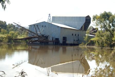
By either access routes, the signposted turn-off to Cocks Dredge is a few hundred metres before the Eldorado township boundary. The Dredge was one of many that were used world-wide to process gold from the vast deposits of alluvial soil that are scattered around the globe.
Cocks Dredge was one of many that were used world-wide to process gold from the vast deposits of alluvial soil that are scattered around the globe. Amazing wealth was generated by such operations, but in many places the environmental costs were high. Dredges had previously been used in the river valleys of places like Colorado and New Zealand, and were introduced to Victoria at the end of the nineteenth century; Cocks Dredge is one of few intact machines found anywhere.
Weighing 2,500 tons, Cocks Dredge now rests (floating) in a pondage it helped create; the Dredge stopped working in 1954, and up until then had obtained about 80,000 ounces of alluvial gold and 1,450 tons of tin.
The sign-posted turn-off to the Dredge is a few hundred metres before the town boundary, and having located the sign-posted access road, you then need to turn into the car park.
Apart from admiring the Dredge from the carpark, you can also take the gang-plank and have a look at this monster’s innards. There is also a walking track that circles around the pondage that the Dredge is floating on; this is a nice 15min leg-stretch.
There is also a walking track to/from the centre of Eldorado that is a popular way to appreciate the local countryside.
Parks Victoria has a handy PDF that details all you need to know about the Dredge (and dredging) and this file can be found on their website (see below).
Returning to the bitumen, and making a left turn, the interesting township of Eldorado is not far away; more details on the township (where there is plenty to see and do, including an excellent museum) from the link below.
Leaving Eldorado with the trip meter set to 0.00, items of interest along the way include . . .
Woolshed Valley
Beyond Eldorado, the area along Reedy Creek (also known as Reids Creek) was first documented by a stock drover (Charles Cooper) who wandered into the area from NSW during the 1840s. Cooper built a temporary woolshed in the area, and when cartographers went to work in the 1860s, the area became known as the Woolshed Valley.
After the discovery of gold in the area (in the 1850s) the Woolshed Valley became a part of life in the fast lane, with notable settlements at Wombat Diggings, Napoleon Flat and Sebastapol.
As well as becoming a hive of activity during the gold rush days, the Woolshed Valley has several links with the Kelly Gang. In June 1880 Dan Kelly and Joe Byrne went to the Woolshed Valley to confront Aaron Sherritt, allegedly a police informer. However, whilst this duo were riding over to see Sherritt, Ned Kelly and Steve Hart travelled to Glenrowan, a decision that would lead to the inevitable showdown and shoot-out.
The Kellys appear to have known the Woolshed Valley quite well, and as well as their home turf (in the Greta area, near Glenrowan) had several hideouts in the Woolshed area. One of these hideaways is still known as Kellys Cave, and can be accessed via Sebastapol Park a pastoral property on the site of the former gold mining township of Sebastapol Flat.
The property is also home to the site of Joe Byrnes cabin, and is a popular stop-over for travellers passing through the Valley, with a gift shop and meals adding to the interest (see below for more details).
More details on the Kelly Gang can be found in the Background Information area of the Homepage.
The road (unsealed after about two kilometres from town) now follows Reedy Creek for most of the distance to the Chiltern - Beechworth Road, with many informal picnic and camping areas along the Creek, making this is a popular venue in holiday periods. Note that this route is impassable in flood conditions, as there is a low level crossing of the Creek to negotiate.
[If the Reedy Creek route is impassable (due to flood conditions), take the direct route to Beechworth; leave town by driving past the Eldorado General Store, then turn left at the Tarrawingee - Beechworth Road., nine kilometres from town. At this point you are about 20km from Beechworth, and the main Wangaratta - Beechworth Tour description has the details from here; see the HomePage for more.]
Assuming that you follow the Reedy Creek route, this is a very scenic drive, with several small cascades on Reedy Creek being visible from the road. These are popular picnic areas; some are signposted, others are less formal, but all are very enjoyable, particularly in spring and summer. Mansons Road and Nieoffs Road (off to the right) are landmarks along this first section of gravel roadway, and both lead to some popular mountain bike terrain.
The former gold mining communities of Wombat Diggings and Napoleon Flat are off to the left of the roadway along here, with extensive market gardening areas (mostly Chinese operated) being to the right. Napoleon Flat was once home to 20+ businesses, amongst them the grand sounding Hibernian and Brittania Hotels.
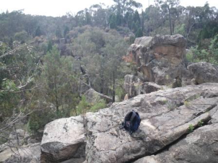
Barry Falls (optional bushwalk, AWTGS-3)
The scenic Barry Falls make a nice optional detour for a short bushwalk, and to enjoy some rugged bushland. Access is dry weather only, and starts by taking Nieoffs Road (a narrow gravel road) that heads off to the right, about five kilometres from Eldorado. Swing right here, and follow this roadway for a little over 1.5km to the second of the entrances to Warbler Track (the first entry is shown on some maps as Currawang Track).
Park near here (somewhere safe), and follow Warbler Track through to an unsignposted y-junction about 400m away. Veer left at this point, and follow this narrow bush track for about a kilometre to where it peters out.
From here there is a faint footpad leading to the base of the Falls, which are now about 300m away. Take care during this last 300m as there is no official walking path, and there is a fair amount of rock hopping to get to the base of the Falls. For the technically minded, the GPS reading at the unsignposted y-junction is 36:19.52s : 146:34.21e (degrees.minutes), the base of the Falls is at 36:20.03s : 146:34.21e, and the vertical drop of the Falls is about 30 metres.
The scenery around the Falls is very pleasing, being open woodlands, set amongst very rocky terrain in a steep sided valley; a great place to linger for morning tea.
Return to your vehicle by the same route, and then drive back to the Woolshed Valley Road for a continuation of the main description. Total walk distance is about three kilometres, taking about an hour to complete.
Rooftop Maps, Beechworth - Albury - Wangaratta Adventure Map does not show the presence of the Falls, whilst the VicMap 1:50 000 sheet Yackandandah shows the Falls in the correct location, but does not show any road access in the vicinity.
[If you want to complete a longer walk, leave your vehicle at the first Warbler Track intersection, and follow this pleasing bush road as it makes a loop around to the north and west of the Falls.
Take care to swing sharp left at the Warbler Track-Currawang Track intersection (about 900m from your vehicle) and follow this through to the unsignposted y-junction referred to above (about 2.4km from your vehicle).
After viewing the Falls return to Nieoffs Road (400m away) by turning right as you come out of the Falls access track, turning left at Nieoffs Road for an easy 1.4km return to your vehicle. Total walk distance being about 6.2km; allow about two hours. Note that (driving wise) this longer access route is not passable by non-4wd vehicles.]
In either case, once back at the Woolshed Valley Road, turn right to rejoin the scenic route towards Beechworth.
Continuing on, Kangaroo Crossing (a low level concrete causeway over the Creek) is encountered about a kilometre from the Nieoffs Road junction, and is a popular (albeit informal) picnic and camping area. There was a high level timber bridge here until the late 1920s, when bushfire destroyed much of the infrastructure of the Valley. Kangaroo Crossing was also home to the Kangaroo Inn (built 1856), one of several grand watering establishments of the Valley.
Once over the causeway, there are a number of 4wd tracks heading off to the left along the next 10km of roadway, as well as a number of access tracks that lead down to picnic-camping areas alongside Reedy Creek.
Reids Hotel was off the the right (just over the causeway) and Buttreys Rock is directly opposite the entrance to Gladstone Track (about 4.5km from the causeway). Buttrey was a small time bushranger, and used this outcrop of granite as cover during his ambush career.

Sebastapol Park (mentioned above) is a little short of seven kilometres from Nieoffs Road, and is to the right of the roadway. Please check opening times before setting off if you plan on calling in at this property; (03) 5725 1635. This is the site of the former township of Sebastopol Flat, and was home to about 80+ businesses at the height of the gold mining era.
McFeeters Road leads down to a small (low level) causeway over Reedy Creek that is not passable in wet conditions. If the water at the crossing is too deep, then you can back-track to the previously mentioned y-junction and continue along the Woolshed Valley Road to the Chiltern - Beechworth Road; turn right at this main road, and look out for the signposted turn-off (to the right) for Woolshed Falls. The Beechworth township description has more details.
However, assuming normal dry-ish conditions, the opposite bank leads to a confusing intersection where you need to follow the main stretch of gravel, basically making a wide loop around to the left, following the Creek upstream. Like Kangaroo Crossing, there used to be an imposing bridge here (Sunbury Bridge) as well as the equally imposing Sunbury Hotel.
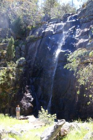
Clear Creek Falls
Once clear of the crossing, an easy run of a little under four kilometres leads to a narrow bridge over Clear Creek, and a small (unsignposted) footpad that leads to the lip of Clear Creek Falls.
The footpad starts on the left side of the roadway, immediately beyond the safety railing of the bridge (this is just before Malakoff Road goes off to the right; if you have passed Malakoff Road, you have passed the Falls).
Having parked the car safely, the footpad leads to the lip of the Falls (take care!) with many excellent views of the spectacular granite country that creates the Falls.
The Falls are usually just a trickle, so the views are as much about the setting, as the Falls themselves.
Access involves a fair amount of rock-hopping, and is not recommended for small children.
Continuing on, it is about 250m to the signposted turn-off (to the left) that leads to Woolshed Falls.
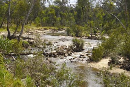
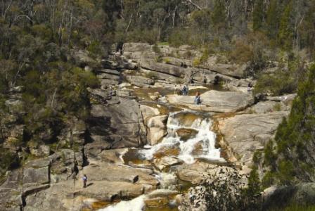
Woolshed Falls
Woolshed Falls (on Reedy Creek) are near the site of the former Reids Creek Goldfields, and both the Falls, and the goldfields, are now included within Beechworth Historic Park. Expectedly, the Falls are at their best after some heavy local rain, and are even better when this occurs during springtime to coincide with the wattle bloom.
The turn-off mentioned above leads, via a short drive, to the carpark that adjoins the Falls Picnic Area. The Falls are clearly visible from several vantage points around the Picnic Area, and there are some short trails that lead to various parts of this scenic cascade.
Many items of human and natural history can be found in this area, for example the water diversion works, and water races associated with gold mining. These and other items of interest can be found on the walking trail; an accompanying brochure on the Falls (available from the Beechworth VIC) adds to the enjoyment of the walking trail. The Parks Victoria website (see below) also has a handy PDF download, with a map and further information on the Falls.
As mentioned above, the Falls are at their most spectacular in springtime, particularly if the creek is running high and the wattles are in bloom (an interesting combination of browns and yellows).
This is a popular venue on weekends, and in holiday periods, particularly in spring and summer.
Returning to the main route, bitumen is encountered just beyond the Falls turn-off, and from here it is now about 1.5km to the Chiltern - Beechworth Road, where you need to turn right for Beechworth (left for Chiltern - Mount Pilot National Park and Chiltern township; see separate descriptions).
Assuming that you continue through to Beechworth, it is only a few kilometres to the main Beechworth - Yackandandah Road. Here you need to turn right for Beechworth (left for Yackandandah); an awkward intersection, take care!
CHILTERN - MOUNT PILOT NATIONAL PARK
Beechworth Visitor Information Centre
Intro Screen on a fresh browser page
COPYRIGHT © 1995-2020, Chris McLaughlin.