BEECHWORTH - STANLEY LOOP
(via Murmungee Lookout and Clarks Corner)
(www.northeastvictoria.online)
TRAVELLING TIME: About 90 minutes (depending on your interests).
DISTANCE COVERED: About 25km.
OVERVIEW MAPS: RACV, Kelly Country.
DETAILED MAPS: Rooftop Maps, Beechworth - Albury - Wangaratta Adventure Map.
SHOPS and SERVICES: Beechworth has a good array of shops and services.
ACCOMMODATION: Beechworth has a wide range of accommodation options, including motels, B&Bs, hotels and caravan parks (Lake Sambell and Silver Creek).
WHEN TO GO: Anytime, but avoid any super-hot days, and sustained wet conditions.
ROADWAY DETAILS: Sealed road to Buckland Gap, unsealed (usually well graded) forest roads to Stanley, and then a 50-50 mix of sealed-unsealed road back to Beechworth.
OTHER INFO: This is a very pleasing drive, mostly through native forest, where the only hazards are those caused by narrow twisting roads; not a real problem if you take care. Local Visitor Information Centres (Beechworth, Wangaratta and Yackandandah) have an informative brochure called Explore the Stanley Plateau which is a useful part of the preparation for this tour; amongst other things, this brochure details some nice walking tracks in, and around, Stanley township.
There is a forest tour brochure available at the Beechworth VIC that covers most of the route described here, however our description is in the opposite direction; this therefore avoids an extremely dangerous right-hand turn from Lady Newton Drive onto the Buckland Gap Road. Distances quoted may vary by several kilometres from one vehicle to another.
The action on the interesting little tour starts by taking Camp Street/Albert Street from the centre of town, and then swinging right onto Kerferd Road (the C524, signposted Myrtleford, a route also known as the Buckland Gap Road).
After leaving the environs of Beechworth, the C524 completes a brief six kilometre climb to Buckland Gap, and once at the Gap there is an information board on the left telling the story of the Royal Oak Hotel, a well known watering hole that stood here from about 1858 to 1958.
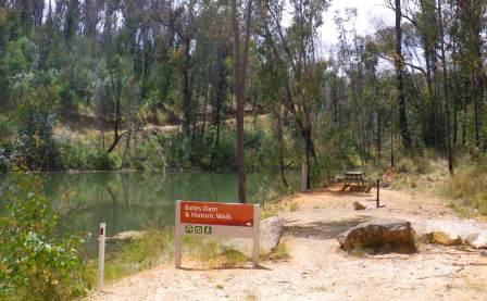
Bates Dam
Turning into the signposted (and unsealed) Lady Newton Drive, a short run (of about 150m) leads to a fork in the road, with the signposted left fork leading to Bates Dam, and the right leading to Stanley.
If you take the left fork, the roadway descends and winds around a hillside for a few hundred metres, before bringing Bates Dam into view. This is a relic from the gold mining days and is home to a nice lakeside picnic area, albeit with very limited parking. There is a short (120m) walking track from the Dam to an old boiler system (ex gold mining of course) and this provides a good excuse for some leg stretching.
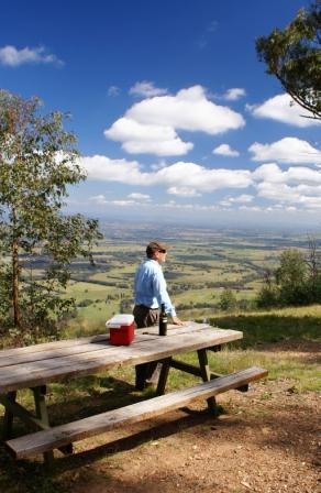
Murmungee Lookout
Returning to Lady Newton Drive, the well maintained surface of this roadway leads after a little under two kilometres to Murmungee Lookout. This is on the right side of the road, and amazing views are the order of the day here, with the flood plain of the Ovens and King Rivers laid out below you. Mount Buffalo is also clearly seen, so long as there isn't too much of that evocative blue haze that typifies the mid-latitudes of planet earth.
Clarks Corner
Moving on from the Lookout, it is a little under two kilometres to a messy intersection where Burgoigee Road (Flagstaff Road on some maps) goes off to the right, followed by Six Mile Road, and then Rooneys Track to the left. About 100m up Six Mile Road (to the left) there is a large open area of cleared land known as Clarks Corner Picnic Area.
The Clark Family lived at this location during the latter part of the 19th Century, and made a living out of growing vegetables, and providing cartage services, for various local mining communities. Little evidence remains of this once thriving business, european trees and a few irrigation channels being the most obvious clues as to a former occupation of this land.
In the early 1950s (about 50 years after the Clarks had moved on) there was a forestry camp at this site, and this was home to many displaced people from war torn Europe. Like many other forestry camps, this one was known as Balt Camp (since many of these refugees were from the Baltic States).
Back on Lady Newton Drive (which has now merged in with Six Mile Road), it is an easy 3.5km run through to Stanley township, arriving at the southern edge of town, with a left turn being required at the Stanley - Myrtleford Road (a right turn at this road leads to Myrtleford - see below for details of this optional route).
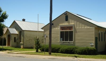
Stanley
Stanley is well known as a prime fruit growing area, producing apples, stone fruits, berries, walnuts and chestnuts. The area was first settled in the 1850s (during the gold rush era, when it was known as Snake Valley) and by 1856 the town’s population was more than 5000.
An optional detour to Mount Stanley is described below (after the main text).
There are many historical points of interest in and around the township. Stanley School was first established in 1857 as an independent community school, the present building, which was constructed in 1872, is one of few brick school buildings of that era remaining.
The Athenaeum was built in 1874 for use as a library and public meeting place and is classified by the National Trust and listed on the Australian Heritage Register. The Presbyterian Church, opened in 1865 (and used until 1942) is similarly classified by the National Trust, and listed on the Heritage Register.
At the other end of the life-cycle, the first recorded burial at the Cemetery was in September 1866, and there are many interesting headstones marking the passing of Stanley pioneering families.
Apart from historic buildings, Stanley also has a charming ambience. Park your vehicle and wander around, buy an apple and/or some other local produce, absorb some of the atmosphere, take some photographs and generally relax before moving on. The Hotel serves an excellent meal, with great ambience.
Other than orchard outlets, a post office cum general store, and the Hotel, there are no retail outlets in Stanley.
The Stanley Hotel was one of seven owned by John A Wallace from Rutherglen (in Scotland). Wallace operated a series of hotels in the North-east, all of them called The Star Hotel. A plaque outside the Stanley Hotel (formerly The Star Hotel) provides a biography of this interesting person who (amongst other things) gave Rutherglen (Victoria) its name.
Orchards and Pine Plantations
From Stanley, heads towards Beechworth for a short distance (a few hundred metres), and then swing right onto the signposted Pioneer Road. Keep right at the unsignposted t-junction about a kilometre from town and ignore Chambeyron Road to the right. This leads almost due north for several kilometres, soon passing alongside orchards to the left, and extensive pine plantations to the right.
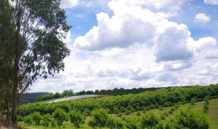
Many orchards in the Stanley and Beechworth areas date back to the gold rush days, when the suitability of the area (soil and climate) was found to be eminently suitable to apple production. Most of the orchards in the area have ’farm-gate’ sales, and these make popular destinations during the berry, cherry, apple and nut seasons.
The pine plantations in the Stanley area were originally established during the Great Depression, using the vast pool of unemployed that were a feature of those times. The plantations were subsequently worked by overseas born interns (mostly Italians) during World War II, and are now in their third harvest cycle, the plantations having a cycle of about 30 years.
Keeping right at the Masons Road t-junction (about two kilometres from town, also unsignposted), there are more plantations on the right, and as these fade away in the rear vision mirror, more apple orchards come into view.
Lake Kerferd
Swing to the left where Hurdle Flat Road makes a sharp left at a cross-roads (a small signpost here reads ’Lake Kerferd Road’ - slightly confusing as this is not Lake Kerferd Road, however it does lead to Lake Kerferd Road. In any case, follow this route through to the signposted right turn to Lake Kerferd. This is a very small scenic lake, being surrounded by pine plantations and is a popular recreation area on hot days. There are picnic facilities at several points around the Lake making this a popular venue.
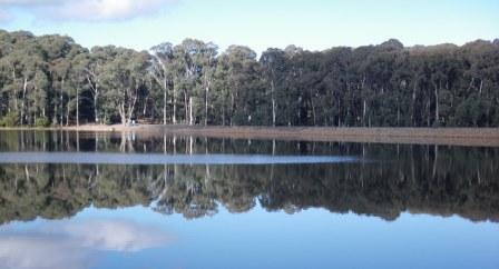
The Lake forms a major part of Beechworth’s water supply, and was named after prominent local George Kerferd who first advocated this site. The dam was declared operational in 1874, and Kerferd went on to become mayor of Beechworth three times, a member of the Victorian Parliament for many years, and subsequently Premier of Victoria in 1874.
As well as ensuring that his home town established a secure water supply, Kerferd was also to ensure that Beechworth got a railway connection to the main Melbourne - Sydney Line.
Returning to Hurdle Flat Road from the picnic area, you need to turn right for a short run back to Beechworth, taking care with the following right turn at the Beechworth - Stanley Road (C525). This leads back into Beechworth township, arriving via a t-junction at Albert Road, where you need to make another careful right-hander.
Alternative finish via Red Hill Road
This is a slightly longer finish to the tour, but it does provide some excellent views of the environs of Beechworth.
Instead of turning left at the cross-roads referred to in the previous paragraph, keep straighahead at this junction, and follow this roadway north for a few hundred metres, to a y-junction where a left turn is required. This basically follows the northern shoreline of Lake Kerferd, finishing at a small picnic area.
As mentioned above, the Lake Kerferd forms a major part of Beechworth’s water supply, and was named after prominent local George Kerferd who first advocated this site. The dam was declared operational in 1874, and Kerferd went on to become mayor of Beechworth three times, a member of the Victorian Parliament for many years, and subsequently Premier of Victoria in 1874.
Turning away from the lake shore, the roadway (Red Hill Road) heads north and meets up with Twist Creek Road, where a left turn puts you on target for Beechworth.
Red Hill Road now meanders around a little, with many excellent views of the surrounding hill country; Stanley is to the left, Beechworth straightahead, and Yackandandah is to the right.
On the final descent to the Beechworth urban area, there is a right turn to make at Elgin Street (just inside the 50km speed limit), and then a left turn at High Street. The main centre of Beechworth is now only a few hundred metres away.
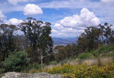
Mount Stanley (optional detour)
Stanley State Forest occupies much of the high country and plateau that clusters around Mount Stanley (1050m) and the drive to Mount Stanley is highly recommended for its great views of the surrounding alpine valleys and high country. The 17km (60 minute) loop described here is about 30% on bitumen, the rest on reasonably well graded forest roads; for safety reasons, this route is to be avoided during sustained wet weather, and on any super-hot days.
The tour starts by taking the signposted Mount Stanley Road from the centre of Stanley township; here a big green sign advises that it is eight kilometres to the Mount. It’s actually about 8.6km, but no matter the drive is still very enjoyable. Heading out of town, the route swings past the Nine Mile Diggings, the epicentre of much of the gold mining activity in the Stanley area in the 1850s; a story board on the right gives much of the historical notes on this era.
The bitumen runs out after about three kilometres (just after Walnut Road), with the scenery so far being dominated by rolling hill country, orchards and plantations.
Stay on this roadway (ignoring all of the side roads) until about the 4.3km mark, where a hard-to-see Mount Stanley Road signpost points to the right at a t-junction. This leads straight into Mount Stanley Scenic Reserve, and the pine plantations are now left behind. For the technically minded, this t-junction is at GPS 36/25.25s : 146/47.28e (degrees, minutes).
The roadway now meanders around the slopes for the next 4.3km, with great views off to the left, as well as a perfect native forest all around; this is mostly open forest, with an amazing floor cover of ferns.
There is a telecommunications tower complex on the actual summit of Mount Stanley, and this can be seen at several points of the ascent. Having arrived at the cleared ground in front of the towers (this is at the junction of Mount Stanley Road and Mount Stanley Jeep Track) there is a road swinging around to the right, and this should be followed until the picnic area comes into view.
There is only limited parking here, but it is right next door to a table and chairs setting, with amazing views down the valley towards Myrtleford and Mount Buffalo. For the technically minded (again) the picnic area is at GPS 36/27.06s : 146/48.14e (degrees, minutes) and is at an altitude of 1053m.
Starting the return down to the township, there are many different perspectives of the same landscape features that you saw on the way up, remembering to turn left at the t-junction referred to above.
Stanley to Myrtleford (optional finish to the tour)
As mentioned in the main description, a right turn at the Stanley - Myrtleford Road leads to Myrtleford. This is a very scenic drive of about 24km, with most of the first 14km being through rolling hill country (orchard country) and then through a nice section of state forest.
The roadway is sealed all the way, and this is an interesting drive, with some great views of the valleys down below. A t-junction at the 14km mark, where you meet up with the Yackandandah - Myrtleford Road, requires a right turn, and from here the centre of Myrtleford is about 10km away.
Beechworth Visitor Information Centre
COPYRIGHT © 1995-2020, Chris McLaughlin.