
BUCKLAND RIVER VALLEY
(www.northeastvictoria.online)
TRAVELLING TIME: Allow about two hours to get to Beveridges Station; other campsites can be reached within an hour.
DISTANCE COVERED: About 40km each way to Beveridges Station (total of 80km from Porepunkah).
OVERVIEW: Spatial Vision, Touring the Victorian Alps.
DETAILED MAPS: Rooftop Maps, Bright - Mansfield Adventure Map.
SHOPS and SERVICES: Myrtleford has a good range of shopping and services; Porepunkah has a general store and a fuel outlet.
ACCOMMODATION: Commercial camping grounds (and motels, cabins etc) at Myrtleford and Porepunkah; excellent bush camping along the Buckland River - all of which have nice river frontages, and all are associated with local gold mining history.
WHEN TO GO: Avoid any sustained wet weather, and any super-hot days.
ROADWAY DETAILS: Generally well surfaced bush roads, albeit narrow-ish in places. In dry conditions, the route is passable to any well maintained vehicle, but 4wd is required in wet conditions. Other than potential problems created by the narrowness of the roadway, the tour is suitable for 4wd rated camper-trailers, and any 4wd rated small caravan (16ft or less).
OTHER INFO: Distances quoted may vary by several kilometres from one vehicle to another.
This scenic tour offers a great mix of high country views and river scenery. It describes the access route to some popular camping areas along the length of the Buckland River, a tributary of the Ovens River, which itself is a tributary of the Murray River. The Buckland River rises around the 1700m peaks of Mount Murray and Mount Selwyn, and is one of Victoria’s most easily accessible alpine streams.

The Porepunkah - Buckland Valley area was first documented by explorers Hamilton Hume and William Hovell in 1824. Major Mitchell also passed this way, and once back in Sydney, gave glowing reports of the area.
This paved the way for European settlement, and in the early 1840s, Thomas Buckland arrived in the area, taking up the Junction Run, at the confluence of two significant rivers at what became known as Porepunkah (these streams would soon be known as the Ovens and Buckland Rivers).
As well as pastoral interests, gold soon became a hot topic of conversation.
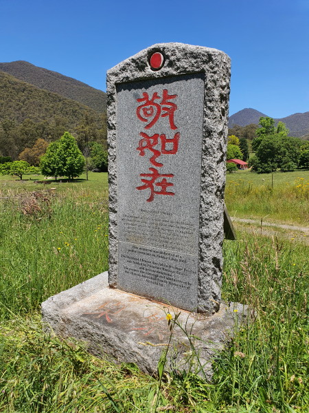
Gold was first discovered in the Buckland Valley in 1853, and this lead to an influx of about 6 000 hopeful miners. Typical of many mining communities, there was a wide mix of ethnicity on the goldfields, and racial tensions boiled over on July 4, 1857, when the Buckland Riot erupted, largely targeting Chinese people who had moved into the areas regarded as ’worked out’ by other diggers.
A special memorial to those people can be found a short distance up Cemetery Lane, a right turn, not far from the Buckland Bridge (see below).
Setting off from the main Porepunkah roundabout with the tripmeter at 0.00 . . .
A scenic drive of about 9.5km past vineyards, timber clad ridgelines and the eastern ramparts of the Mount Buffalo massif takes you to a nice view of Howells Falls. This is to the right of the roadway, and reveals a massive outcrop of granite with white water cascading down its face.
Continuing up the valley, the narrow-ish Buckland Valley Bridge is encountered at about 12km, with a small pull-in being located on the other side of the Buckland River - marking the first direct contact with this scenic waterway.
The bitumen is left behind soon after the bridge, and at 18km the first of several excellent campsites is clearly visible down to the left (on the river flats). This is one of the larger campsites in this area, with plenty of flat ground, plenty of fireplaces, good access to the river and great shade from some nice tall timber.
A place called ’12 Mile’ is off to the left at about 19.5km, and from here a designated track leads down to the river, and a popular fishing area.
Junction Bridge (where the Buckland River East Branch and Buckland River West Branch meet) is at about 22.5km, with our route continuing to follow the East Branch of the river.
The route now weaves its way up the East Branch Valley, with many excellent views of the crystal clear river being visible at regular intervals. Most of these views are from places where the roadway has climbed significantly above the river, providing clear vision of a perfect alpine stream with several gorge systems, and many white water cascades to admire. Given the nature of the roadway (with an unforgiving drop-off to the left) these are views for passengers only.
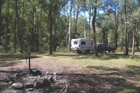
About two kilometres from Junction Bridge, there is an unsignposted track going off to the left; this is Clear Creek Track, and leads to a crossing of the Buckland River, as well as a string of excellent campsites. All of these campsites are five star locations, but unless you have a 4wd vehicle, it would not be wise to attempt the crossing of the Buckland River to get to them.
As well, the sites furthest from the river crossing are in amongst some old goldfields, and it would pay to stay on cleared ground at all times as there are several unprotected mine shafts in the area. Mullock heaps and other leftovers from the mining days are also around in abundance.
Keep left at an unsignposted y-junction at about 26km, and lookout for a nice camping area off to the left soon after this.
Miners Right, and a block of pastoral country, is encountered at the 28km mark, with the spacious Shippens Flat camping area following soon after this.
Leinster Flat (another spacious camping area) is about two kilometres further up the valley, and is quickly followed by Good Hope Flat; Head Race Flat is a further two kilometres away, and The Bend another two kilometres after that - all of which offer very good riverside camping.

Not far beyond The Bend, the first serious road junction of the tour comes into view. This is where the Mount Selwyn Road goes off to the right at a y-junction, with Selwyn Creek Road going off to the left. Both of these roadways lead to the Mount Selwyn area, but only the left option leads to Beveridges Station camping area - the final destination of this tour.
Beveridges Station is about 39km from Porepunkah and is reached by a winding bush road; one that is even narrower than the roadway before the y-junction mentioned above - take care if you are towing a caravan.
Once at Beveridges, there is an amazing amount of space to set up camp - getting away from the neighbours is no problem here, and the river is (once more) at your doorstep.
From here, it is time to head home, hopefully at a slow enough pace to pick up some more great views of the river that you may have missed on the way up the valley.
BRIGHT (includes Canyon Walk and Bakers Gully)
COPYRIGHT © 1995-2021, Chris McLaughlin.