BUFFALO RIVER VALLEY
(includes Mount Selwyn)
(www.northeastvictoria.online)
TRAVELLING TIME: Depending on options, up to about five hours; the longer options are best taken over at least two days as the camping is really good.
DISTANCE COVERED: Up to about 200km (from Myrtleford) depending on options taken.
OVERVIEW MAPS: Spatial Vision, Touring the Victorian Alps.
DETAILED MAPS: Rooftop’s Bright - Mansfield Adventure Map. The tour is also covered by VicMap 1:50 000 Buffalo and Selwyn; these are available in print, and GPS (digital), format.
SHOPS and SERVICES: Wangaratta and Myrtleford are the closest main commercial centres to the start of this tour, and both offer a good range of shopping and services. Porepunkah has a general store, a fuel outlet and a hotel.
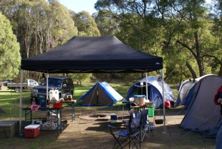
ACCOMMODATION: Commercial camping grounds (and motels, cabins etc) at Porepunkah; excellent bush camping at Nug Nug (see text) and along the Upper Buffalo River. There are also several places in the higher parts of the tour that make good campsites for small groups, in particular along Selwyn Track.
WHEN TO GO: Avoid any sustained wet weather, any super-hot days, and any prolonged dry periods.
ROADWAY DETAILS: Generally well surfaced bush roads, slippery in the wet. Not recommended for 2wd vehicles, but a good tour for all 4wd vehicles, with or without a 4wd rated camper-trailer. Soft-roaders should not encounter any problems in dry conditions. Solo 4wd vehicles will generally have no problems in dry conditions; a minimum of two vehicles is recommended for wet conditions. Seasonal road closures apply to the Mount Selwyn area.
OTHER INFO: Distances quoted may vary by several kilometres from one vehicle to another. See also the detours to the Rose River Valley, and Mount Selwyn (after the main text). Like many other parts of the high country, the sign-posting in this area is not the best, and the map needs to be followed closely.
This scenic tour describes the access route to the popular camping areas along the length of the Upper Buffalo River. The Buffalo River (and its major tributaries, the Rose and Dandongadale) rises in alpine country around Mount Selwyn and Mount Cobbler, and is a tributary of the Ovens River, which itself is a tributary of the Murray River.
The Myrtleford - Dargo Goldfields Route, which the first part of this tour is based on, was pioneered in about 1865 by John Bryce. Bryce ran a transport company, running stores between the mining operations at Bright, Harrietville and the Dargo area.
With snow closing down his transport operations every winter, Bryce had obvious motives in seeking out a newer, less exposed, route than the one that ran via what is now the Great Alpine Road. The Bryce Family later became the owners of Wonnangatta Station. As well as gold, timber getting and pastoral activities were lures for the early settlers, with both of these activities continuing to the present day.
For modern day travellers, the action of this scenic tour begins in the centre of Myrtleford by taking the sign-posted Lake Buffalo Road (also called the Buffalo River Road). This leads for about 20km past vines, olive groves, and former tobacco farms to the scenic Lake Buffalo.
Landmarks on the way include Nug Nug Reserve (excellent camping amongst tall timber) at 13km and Osbournes Bridge after 16km. Once in sight of the Lake, there is a nice picnic area to the left (just before the crossing the spillway) and this makes a good spot to take-five before hitting the gravel.
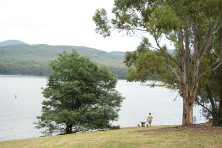
The Buffalo Road crosses the spillway of the Lake, so there are good views of the water in this section, with the not too distant high country providing a nice backdrop.
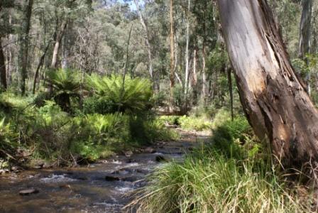
The bridge over the Rose River is encountered at 31km (see note below) and the bitumen is soon left behind as the first of many riverside camping and picnic areas come into view (Blades at 37km; Tea Tree at 39km and Manna Gum at 41km).
After Manna Gum the Road starts a long climb away from the River, finally dropping back down to the river flats at Abbeyards (54km), followed by McIver two kilometres later. All of these camping areas are very scenic and popular during holiday periods, but fortunately most of them are quite large.
The Abbeyards camping area is alongside a very interesting section of rocky river bed, and has heaps of ambience. Abbeyards got its name from the original homestead at this property, an elaborate timber structure that resembled an abbey; the stockyards then became known as the Abbey Yards. This Canadian designed homestead was lost in the 1919 bushfires.
After passing through Catherine Station (private property, originally built in about 1925, but destroyed in the 1939 Black Friday bushfires) the road splits in two (at the 66km mark) becoming the East Buffalo Road and the West Buffalo Road. The former is the route for today, and this leads to more riverside camping areas alongside the East Branch Buffalo River (which is now much smaller than before).
The last campsite (about four kilometres from where the East and West Buffalo Rivers split) is the turn-around point of the route, as beyond here gets into 4wd territory, with a climb up to the alpine country of the Mount Selwyn area (see the optional detour below).
Rose River Valley
This is an optional detour from the main route, and leads through to Paradise Falls, and the Upper King Valley near Whitfield.
Coming from Myrtleford, follow the Buffalo River Route until you reach the Rose River Bridge, and the Dandongadale Road turn-off, this point being about 49km from Myrtleford.
This leads to the scenic Rose River Valley, and thence the King Valley, making a nice loop through some pleasing back-country. See the Rose River Valley Tour (link below) for further details.
Mount Selwyn
(4wd only; low range and high ground clearance required)
This is an optional (dry weather only) alpine detour from the main route, and leads (via seasonally closed 4wd tracks) over the ridge, through to Mount Selwyn, and then down to the Buckland River Valley. Allow about four hours to get through to the Buckland Valley; this will allow plenty of time to look around, with some safety margin time-wise built into the day.
As mentioned above, after passing through Catherine Station the road splits in two, becoming the East Buffalo Road and the West Buffalo Road. The former is the route for this detour, and leads to more riverside camping areas alongside the East Branch Buffalo River (it is now much smaller than before).
The West Humffray Road comes up (on the left) after 78km from Myrtleford, and is this is definitely the road-less-travelled, being quite grassy in the centre of the road; however it provides great views to the left of a spectacular steep sided valley.
After about 5.5km, the West Humffray splits into Whites Track (to the right) and Selwyn Track (also known as Canyon Road/Track, to the left). Taking Selwyn Track leads into a terrific area of tall timber, and some really steep pinches where low-range may be required. Note that much of this seven kilometre section is unmetalled, and is very slippery in wet conditions. This is actually part of the route of the long distance Australian Alpine Walking Track (AAWT).
From here, the AAWT climbs to the summit of South Selwyn (1398m), and this makes an enjoyable short walk after spending all that time in a vehicle.
Continuing on, and arriving at a t-junction (Mount Selwyn Road), the route heads off to the right; this short-cut passes by the Selwyn Hut site (it was destroyed in the 2003 bushfires).
Depending on whether you believe road signs or maps, Mount Selwyn Road meets up with Tea Tree Range Road after about 5.5km from the T-junction. Turn left here, and head mostly downslope to an awkward left turn. This is now Selwyn Creek Road, although on our last visit the signposts said that we had already hit Selwyn Creek Road!
At this point you are now about 106km from Myrtleford, and firmly in the catchment of Gippsland’s Wonnangatta River (Selwyn Creek is a tributary of the Wongungarra River, which in turn flows into the Wonnagatta).
Selwyn Creek Road follows the said Creek for several kilometres, gradually climbing up on to the ridge system that separates the Wonnangatta catchment from that of the Buckland.
The Twins Jeep Track goes off to the right at about the 113km mark, and the route then commences a steady descent to the Upper Buckland River.
Mount Murray North Track is encountered (on the right) at 121km, and this is soon followed by the sign-posted turning to Beveridges Station at 123km. This is the first of many designated camping areas alongside the Upper Buckland River - all of them have heaps of room and are great places to stretch out for a few days; expectedly these are popular in holiday periods.
The camping areas continue almost all the way to Buckland Junction (140km), and then it is a straightforward run to the bitumen at about the 150km mark. This is at the bridge over the River, and there is a nice little picnic area on the left just before crossing the bridge.
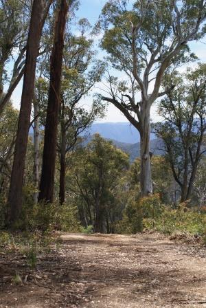
On the way to Porepunkah there are great views of the Mount Buffalo massif to the left. Most people get to see Mount Buffalo from the north and west, but this (eastern) side of the mountain has even better views.
See the separate Buckland Valley Tour for more details of this great venue.
ROSE RIVER VALLEY (Myrtleford, Lake Buffalo, King Valley)
Myrtleford Visitor Information Centre
Wangaratta Visitor Information Centre
Intro Screen on a fresh browser page
COPYRIGHT © 1995-2020, Chris McLaughlin.