EUROA
(www.northeastvictoria.online)
Like much of the North-east, the Euroa area was first documented by the explorers Hume and Hovell in 1824, and first settled by pioneers from the Sydney district. The Hunter Brothers established their Urowa Run in 1837; and in 1838, the Templeton Family established Seven Creeks Station. The Forlonge Family took over Seven Creeks in 1851, the same year that Victoria was separated from the Colony of New South Wales. Legislation to allow further expansion of settlement in the area was quickly passed by the new parliament, and the framework for the current Strathbogie Ranges Shire came into being.
As the Shire, and the township grew, so did its involvement with current events, and in 1878 Ned Kelly and his gang robbed the local branch of the National Bank.
The Kellys had previously attacked a police camp at Stringybark Creek in October 1878, and in the ensuing shoot-out, three police officers were shot dead.
After this incident, the Kellys rode into Euroa on 11th December, and robbed the National Bank. This daring robbery was followed by the hold-up of an entire town, Jerilderie in New South Wales. The Kellys held the town captive for three days, before returning to their hideout at Greta in the King River Valley.
See the Bushranger Section for more on The Kelly Gang, and other bushrangers.
Modern day Euroa is now by-passed by the Hume Freeway, and is much more peaceful place than it was when bushrangers roamed free, and when the Hume Highway went through the eastern part of the town.
The town has a good array of shops and services, and accommodation options include several motels, some holiday cottage rentals and a creekside caravan park. It is also at the centre of a renowned horse breeding area.
Things to see and do include . . .
Victoria Cross Memorial
The Euroa district is the only area in Australia that has had three Victoria Cross recipients, and it now has a very fitting memorial to the heroism of three great people.
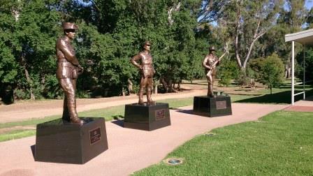
The Memorial consists of three excellent statues, as well as some very informative story boards, and is well worth visiting, being just alongside the RSL in Kirkland Avenue.
Lieutenant Maygar won his VC for rescuing an injured comrade during the Boer War in 1901, he was subsequently killed during World War One.
Lieutenant Frederick Tubb and Corporal Alexander Burton won their VCs at Gallipoli in August 1915, whilst repelling a Turkish counter-attack. Burton died during the attack, and awarded his medal posthumously, whilst Tubb died on the Western Front in France two years later.
See the Monument Australia website for more details (Monument Australia)
As well as the statues at the Park, Maygar and Tubbs are remembered in the naming of two prominent hills after them, and the main bridge in Euroa (the former Hume Highway Bridge) is called Burtons Bridge.
Euroa Heritage Trail [AWTGS-1]
This very enjoyable urban walk incorporates many of Euroa’s historic buildings. Walking time is one to two hours, depending on how often you stop for photography or coffee, the distance covered is about three kilometres.
There is an official heritage trail, however the simplified description given here deviates slightly from the one described in the Euroa Heritage Trail (see download option below for the detailed brochure).
The start and finish of the walk is at the Seven Creeks Picnic Area (just off the Old Hume Highway, adjacent to Burtons Bridge over Seven Creeks; the Bridge is named after Alex Burton VC, see above - a local and Australian hero).
The Seven Creeks Picnic Area can be reached by turning off the Hume Highway at Kirkland Avenue West. If approaching from the south this is a left turn just before the Seven Creeks Bridge; from Benalla it is the first turn on the right immediately after crossing Seven Creeks. There are toilets and barbeque facilities (electric) at the picnic area, and a reasonable amount of car parking.
The walk starts by crossing the small bridge leading over Seven Creeks. This is at the downstream edge of the picnic area, near a small weir. Once over the bridge veer left, and follow the creek fairly closely for about 200m. Don’t forget to admire the superb stand of native trees, the remnants of a forested area cleared for the Euroa Cricket Ground.
At the end of the Cricket Ground, veer left and recross Seven Creeks at a small bridge. This leads back into Kirkland Avenue near the site of Kirklands Homestead. Kirkland was one of the first settlers in the Euroa area, and held the Urowa Run during the years 1844-51.
Turn right at Kirkland Avenue, and walk to Railway Street and the end of the block. This leads past the Old Flour Mill (c1873), the Uniting Church (c1889) and an oak tree with memorial plaque, commemorating the coronation of King Edward VII in 1902.
Turn left at Railway Street, and follow this wide street through to the railway overpass, noting Binney Street on your left as you do so. On the way, you will pass the impressive Euroa Hotel and the former Memorial Hall (now an office complex).
The Hotel is a popular venue for wining and dining, and serves a very enjoyable meal. After your meal, take the time to admire the stairway that leads to the accommodation, a beautiful structure that includes a Juliet Balcony.
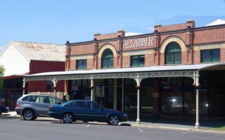
Returning to Binney Street, the main commercial thoroughfare of Euroa, the National Bank building is on the corner, and this is acknowledged as one of the finest examples of Queen Anne style bank buildings in Victoria, this particular building was erected in 1884.
Halfway down the first block of Binney Street is Blairgowrie, a great example of colonial architecture, dating from 1890. The plaque above the facade includes the name of the original owner, Mr H London, a local chemist.
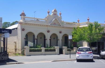
At the corner of Binney and Brock Streets there are two notable buildings, the Post Office (1890) and Burtons Stores (1892).
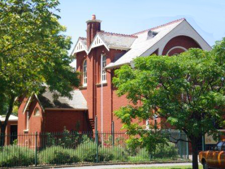
Continuing down Binney Street, the ornate Euroa Courthouse (1890) is passed, one of many buildings in the town registered by the National Trust.
Finally, at the corner of Binney and Bury Streets the Methodist Church (1897) is encountered and a left turn here puts Kirkland Avenue, and the start of the walk, in view.
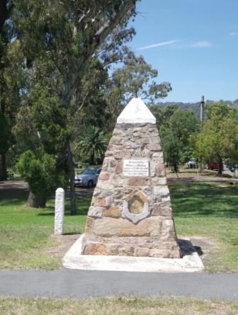
The nearby Seven Creeks Hotel (just over Burtons Bridge) serves an excellent meal, and makes a good finale to the walk (the Hotel was built in 1865). Prior to crossing the Bridge, there is a memorial to the Hume and Hovell Expedition of 1824, on the opposite side of the roadway.
Having done all that walking, it is time to check out the coffee shop scene in Binney Street, where Alberts Cafe and The Weekend Local are amongst the favourites with locals, and visitors.
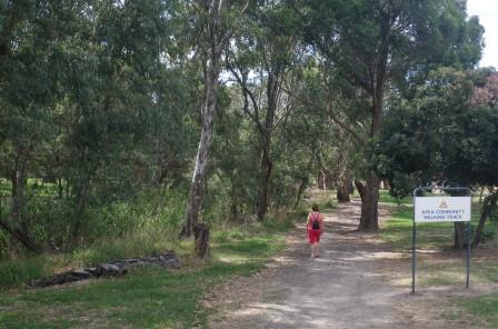
APEX Bicentennial Walking Track [AWTGS-2]
This creekside walk was established for the Bicentenary in 1988, and loops around the riverine environment of Seven Creeks, both upstream and downstream from the Kirkland Avenue parklands. Given the informal nature of the walking track, it is feasible to make up your own route, however the description here starts from the Kirkland Avenue picnic area alongside Seven Creeks, just off the old Hume Highway.
The upstream part of this nice little adventure kicks off by crossing over the Old Hume Highway, passing the memorial to the Hume and Hovell Expedition (mentioned in the previous description), on the opposite side of the roadway.
Continue along the roadway, with another picnic area to your left, followed by the caravan park (also to the left). Soon after the caravan park, there is a signposted walking track off to the left, leading to the riverine vegetation of Seven Creeks.
The walking track now basically follows Seven Creeks upstream, with plenty of shade, and the occasional opportunity to get down the the waterside. The track meets up with a roadway in a few places, but for most of the distance is a segregated walkway.
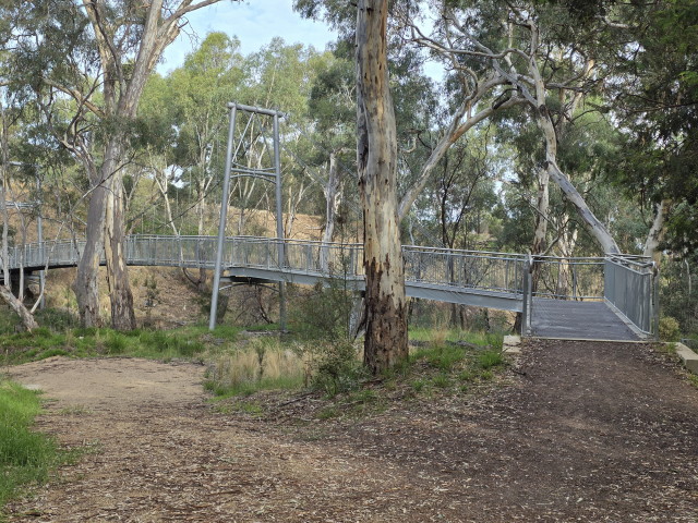
Having made it to the turn-around point (about 1.5km from the start), there is an impressive pedestrian bridge over the Creek, and from the other side of the water, you need to swing left so as to pick up the route back to the start.
A further 1.5km now leads back to town, arriving at the Old Hume Highway alongside the Seven Creeks Hotel (built in 1865).
From here, you just need to cross over the bridge, and the start point is just off to the right.
The downstream part of the walk (about 3.3km overall) involves leaving the picnic area by crossing over a pedestrian bridge, and then turning left, so as to swing past the bowling and croquet club.
Continue following the gravel walking path, and pass under the Sydney-Melbourne Railway Line. This leads to a bridge on Factory Road, which you need to carefully cross over, so as to get to the ‘town’ side of the Creek.
Once over the Bridge, swing down to the left, and pick up the gravel track once more. The track continues to follow the Creek, upstream towards the town centre, apart from a short stretch where you need to take to the bitumen of Spencer Street.
Veering left at the top of Spencer Street, the walking track now leads back to Kirkland Avenue, the Victoria Cross Memorial and the picnic area at the start of the walk.
As mentioned above, having done a lot of walking, it is time to check out the coffee shop scene in Binney Street, where there are many good choices, all of them favourites with locals, and visitors.
Balmattum Hill [AWTGS-3]
This nice little adventure kicks off from near the memorial to the Hume and Hovell Expedition.
Continue along the roadway, with the caravan park on the left.
Soon after the caravan park, there is a signposted walking track off to the left, leading to the riverine vegetation of Seven Creeks.
The walking track now basically follows Seven Creeks upstream, with plenty of shade, and the occasional opportunity to get down the the waterside. The track meets up with a roadway in a few places, but for most of the distance is a segregated walkway.
Having made it to an impressive bridge, cross over the Creek, turn right, and sneak under the Hume Freeway, so as to pick up the Balmattum Hill walking track.
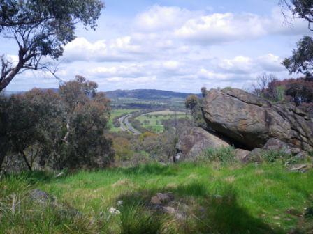
This is an enjoyable walk that leads to the summit area of Balmattum Hill, a local highpoint of the Strathbogie Ranges.
Continuing upslope, the track is now quite narrow, and winds around the hillsides on a relentless quest for the summit. There are many nice views on the way up, including glimpses of Euroa township and the surrounding ranges.
The geographic position of the township is also quite apparent, with the cleft between the ranges providing all the answers as to why Euroa is situated where it is.
The walk takes about three hours to complete, including an allowance for time spent having morning tea or lunch on the bench at the top.
Further afield, the previously mentioned Euroa - Strathbogie Ranges Tour (see link below) calls in at most of the notable features (man-made and natural) of the surrounding area, and takes 3-5 hours to complete, depending on your interests.
The Strathbogie Shire has also documented a series of walks in the area; see "strathbogieranges.org.au/local-walking-guides" for more details (link below).
EUROA - STRATHBOGIE RANGES (Balmattum Hill, Gooram Falls, Polly McQuinns Weir and Mount Wombat)
Euroa (Strathbogie Shire) website
Euroa Heritage Trail Brochure (PDF)
Strathbogie Shire Walks Brochures (PDFs)
Intro Screen on a fresh browser page
COPYRIGHT © 1995-2026, Chris McLaughlin.