KIEWA VALLEY HIGHWAY
(Albury-Wodonga, Kergunyah - Mount Beauty)
(www.northeastvictoria.online)
TRAVELLING TIME: About 90 minutes.
DISTANCE COVERED: About 85km. Distances quoted are from the roundabout at the southern end of High Street, Wodonga.
OVERVIEW MAPS: Touring map of Victoria.
DETAILED MAPS: UBD, Albury-Wodonga, Murray River and High Country (all one map).
SHOPS and SERVICES: Albury-Wodonga has a full range of shops and services. Kiewa-Tangambalanga has a general store, and a fuel outlet; similarly at Kergunyah, Dederang and Tawonga. Mount Beauty has a good range of shops and services, as well a fuel outlet.
ACCOMMODATION: Albury-Wodonga has a wide range of accommodation options; Kergunyah has a riverside caravan park, as does Mongans Bridge and Tawonga.
Mount Beauty’s accommodation options include motels, a riverside caravan park, and several excellent boutique choices.
WHEN TO GO: Anytime of the year is enjoyable; autumn is very scenic because of the changing colours of the non-native trees (mostly poplars); winter is excellent because of the snow-capped peaks at the top of the Kiewa Valley.
ROADWAY DETAILS: Bitumen all the way.
OTHER INFO: Distances quoted may vary by several kilometres from one vehicle to another. See the Wineries Listing for further details of the wineries mentioned in the text.
History of the Kiewa Valley
The Kiewa Valley was an aboriginal trade route for many thousands of years, and was first documented by Europeans in the 1820s. This lead to the gradual influx of new settlers in the valley over the next twenty years, most of them having made the overland journey from the Sydney area.
As well as being enthusiastic about their new found homeland, the early settlers were keen to exploit the perceived benefits of grazing cattle on the nearby high country, and in the Upper Kiewa Valley, the Bogong High Plains were first documented by stockriders Brown and Wells in 1851.
Following on from this discovery, the Wallaces of Kergunyah established a summertime routine of high country grazing, a practice that was followed by many other pastoralists of the North-east. From elsewhere in the Kiewa Valley, the Roper, Maddison, Cooper, Ryder and Howman families also drove cattle into the alpine areas of the Upper Kiewa River.
The valley remained entirely pastoral until the late 1940s, when construction of the Kiewa Hydro-electric Scheme began. This brought about many changes, one of which was the widening, upgrading and sealing of the Kiewa Valley Highway, as well as the construction of a new town (Mount Beauty). See the Kiewa Valley Historical Society website (link below) for more details of this amazing valley.
THE TOUR
This scenic route basically follows the Kiewa River upstream from Wodonga to Mount Beauty, where the East and West Kiewa Rivers have their confluence. Kiewa is the aboriginal word for ’sweet water’, one of many aboriginal place names to be found during this tour.
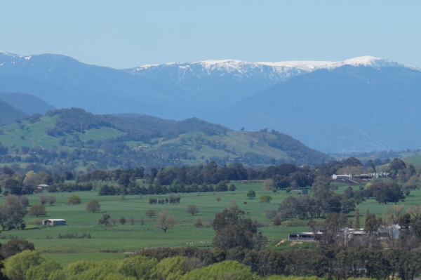
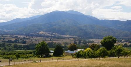
The alpine streams (the East and West Kiewa Rivers, that form the Kiewa River) rise in the heart of Victoria’s Alpine Region, and their catchment areas include much of the Bogong High Plains, as well as parts of Mount Bogong (Victoria’s highest peak).
The Kiewa River flows past the townships of Mount Beauty, Tawonga, Kergunyah and Gundowring before joining up with the Murray River, just to the east of the Albury-Wodonga urban area. Expectedly, the Kiewa River is the main feature of the Kiewa Valley, and the Kiewa Valley itself is one of the most majestic geographical features of the North-east.
With the tripmeter set to zero, the action begins by taking the Kiewa Valley Highway exit (the C531) from the Murray Valley Highway, about seven kilometres east of Wodonga CBD. This leads to an undulating run along the valley floor, passing the Yackandandah Road (the C527, off to the right) after about five kilometres; Yackandandah being about 20km away at this point. See the alternative route to Mount Beauty via Yackandandah after the main text, for a scenic detour via ’the valley of gold’.
Another five kilometres leads to the new bridge over Yackandandah Creek, the previous one having been washed away in the floods of January 2011.
Just beyond the bridge, the second access route to Yackandandah goes off to the right; Yackandandah being about 17km away at this point.
Kiewa - Tangambalalanga
The small communities of Kiewa - Tangambalalanga follow shortly after the Yackandandah access, and are both off to the left of the Highway. The site of Kiewa township was first settled by members of the Huon de Kerrileau Family in 1837, and was one of the first pastoral runs in the Kiewa Valley.
The adjoining Tangambalalanga Run was taken up in 1838; both township are overshadowed by Mount Murramurrangbong (altitude 880m; to the south-west) and both service a prosperous dairy farming area.
Kergunyah - Gundowring
Kergunyah is about 10km beyond Kiewa - Tangambalalanga; the Kergunyah Run was first taken up by the Morrice, McKenzie and Wylde Families in 1838, later passing to the Wallace Family in 1868, a family who are still significant land owners in the area.
Kergunyah township is slightly off the Highway, and has a general store, as well as an informal riverside picnic-camping area.
Beyond Kergunyah, Gundowring is signposted (off to the left) and was first settled by Jane Romaine Barber in 1838; her son George would later marry into the family of explorer Hamilton Hume. The Gundowring area is still predominantly pastoral (as it was in the 1800s) having had a foray into tobacco growing from about 1890 to about 1990.
Dederang Gap and Dederang
The Highway now veers right, with the Dederang Gap picnic area being on the right-hand side of the roadway. Other than being on the wrong side of the bitumen, this makes a nice stop-over point, with great views up the valley.
Continuing up the valley, the route leads past the Dederang switching yards; this is where electricity output from the Dartmouth and Kiewa hydro schemes merge, ready for transmission over to the Ovens Valley, and then further south.
The Dederang switching station also marks the return of the Yackandandah detour previously referred to, Yackandandah being about 24km from this intersection.
The route now passes through the valley to the small, scattered settlement of Dederang, which has a couple of historic churches, and excellent views of the nearby Victorian high country. In winter and spring the views of distant snow-capped mountains are particularly impressive.
The Dederang Run was taken up by the Pinsent and Roberts Families in 1845, with the Keegan Family (after whom nearby Keegans Bridge is named) arriving in the 1850s.
The modern day township has a popular hotel, as well as a general store and fuel outlet. Dederang is also home to the Dederang Races, held at regular intervals throughout the year.
Once clear of Dederang, the Kiewa River comes into view (down to the left) and this waterway is now followed fairly closely, all the way to Mount Beauty.
The Myrtleford Road (C534) goes off to the right about seven kilometres from Dederang, and provides a scenic route through to the Great Alpine Road at the small township of Ovens. This enjoyable drive was largely constructed by the labour force of the Great Depression, and was completed in 1937.
Mongans Bridge and Red Bank
Mongans Bridge (Bay Creek Road) is the next notable intersection, and leads to the popular Mongans Bridge camping area.
The turn-off (to the left) to Red Bank is about seven kilometres after Mongans Bridge, and provides easy access to many hundreds of metres of Kiewa River frontage - a popular spot for anglers.

Tawonga
A further seven kilometres leads to the scattered settlement of Tawonga, along with its general store and fuel outlet.
The Tawonga area was first settled by the Hollands, Maddison, Cooper and Ryder Families in 1857, and these names still predominate in the Tawonga area. As settlement in this are pre-dated the construction of the Kiewa Valley Highway, all of the commerce in the Tawonga area was originally conducted via Bright - a situation that would not substantially change until the advent of the Kiewa Valley Hydro-electric Scheme in the 1940s.
The Roper Family were also amongst the earliest settlers at Tawonga, and John Roper was a member of Ludwig Leichhardt’s 1844 Expedition to the Gulf of Carpentaria; the Roper River, and Roper Bar, being named after John Roper of the Kiewa Valley.
See Diane Edmondson‘s excellent book Tawonga Remembers : An Historical Documentation for a great account of the Tawonga area‘s history.
The Tawonga community website (link below) also has a section on the history of the area.
The turn-off (to the left) for Mount Bogong is at the top of the next ridge, at a cross-roads once home to the Bogong View Hotel. See the Mount Beauty description for more details of the Mount Bogong area.
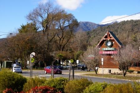
Mount Beauty
Continuing for the final few kilometres towards Mount Beauty, the turn-off to Bright (the C536) goes off to the right; see the description on the Main Menu for more details of this great drive.
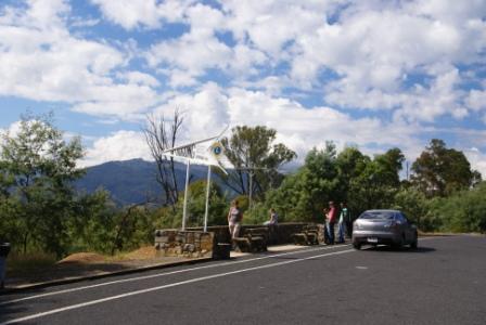
A few kilometres before the township of Mount Beauty there is a viewpoint on the east (left) side of the highway, and this makes an excellent photography stop as the view is of Mount Bogong, Victoria’s highest peak. Again winter and springtime views are best, as this impressive looking mountain usually has heavy snow cover.
Mount Beauty (population about 2300) a good array of shops and services, centred around Hollands Street, as well as motels and some small restaurants. The township, like many others in and around the high country was purpose built as part of a hydro-electric scheme, the Kiewa Scheme in the case of Mount Beauty - see the separate description for more details.
Yackandandah (optional detour)
This nice detour offers a pleasing 29km route through rolling hill country, to the fascinating historical township of Yackandandah.
Take the Kiewa Valley Highway out of Wodonga (as described above) and then swing right onto the first signposted Yackandandah turn-off, and from here about it is about 19km to Yackandandah.
From Yackandandah you can continue through to the Upper Kiewa Valley by taking the Myrtleford Road, but instead of driving through to Myrtleford, take the Dederang turn-off (a slip road off to the left 10km out of Yackandandah). This leads through pleasant hill country to the small, scattered settlement of Dederang and the Kiewa Valley Highway.
Take care at the intersection of the Yackandandah Road and the Kiewa Highway (just past the Dederang Power Switching Yards) as visibility is not good.
See the separate description of Yackandandah for more details of the township.
Kiewa Valley Historical Society
Mount Beauty Visitor Information Centre
Intro Screen on a fresh browser page
COPYRIGHT © 1995-2024, Chris McLaughlin.