COROWA and WAHGUNYAH
(www.northeastvictoria.online)
Wahgunyah (aboriginal for big camp) was occupied by aboriginal hunter-gatherer-fishing groups for many thousands of years prior to the 1830s, when their corner of paradise was truncated by European settlement.
John Foord and John Crisp were amongst the first European settlers in the North-east, having arrived in 1839, and taken up the Wahgunyah Run in 1841. Their vast property straddled the Murray River, at the present day sites of the twin river towns of Wahgunyah and Corowa (formerly Wahgunyah North).
Other settlers followed, and for many years (from 1852 to the early 1880s) Wahgunyah was an important paddle-steamer river port, servicing the gold mining towns of the North-east. The advent of the railways scuttled the riverboat trade, with a regular train service from The Springs (Springhurst) to Wahgunyah starting in 1880 (the service was discontinued in 1976).
Over the Murray River, the New South Wales town of Corowa played a significant part in the move towards the federation of the Australian colonies in 1901. The Border Federation League was formed here in 1893, and this organisation was a major force behind the subsequent federation of the five original signatories to the country we call home.
Story boards in the main street (Sanger Streer) detail the progression of the individual colonies to Federation. The museum also has plenty of information on this, and other local, events.
Western Australia did not join the Federation until 1902, and remains the only state that has the legal option of seceding from the Commonwealth of Australia.
The town’s history stretches back to the riverboat days, and has an excellent array of buildings to admire, most notably from the Federation era, as well as some great art-deco architecture.
The town has several motels and caravan parks, and is a popular base camp for visitors to the Rutherglen Winery Area. The town’s population is about 5200, and this supports a good shopping centre, and a wide range of services and amenity. See the Corowa website for more information on the township.
There are four caravan parks close to town, all of them with riverside frontages (see the Caravan Park listing on the homepage).
The modern day townships of Corowa and Wahgunyah are much quieter than in the gold rush days, and things to have a leisurely look at around the area include . . .
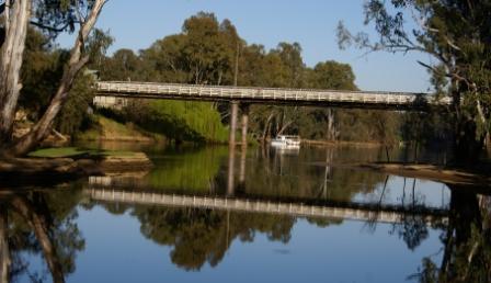
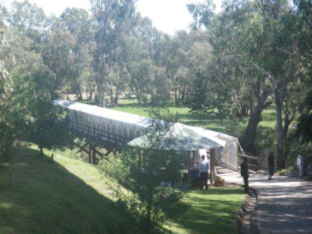
The single-lane John Foord Bridge links the two towns, and is one of only a few bridges over the Murray River that are named after a person. The Bridge opened in 1892, and replaced the original toll bridge that had been in operation since 1862 (the 1862 bridge having replaced a punt service). The Foord Bridge was later upstaged by the sleek Federation Bridge (built in 2005).
The Customs House (on the southern approach to the Foord Bridge) was built in 1886, and was an important part of the pre-federation taxation war between adjoining states.
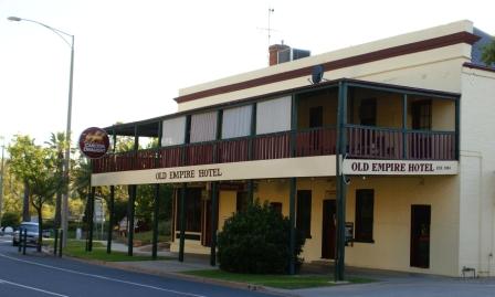
The Empire Hotel (just before the bridge) dates from 1910, replacing the original hotel of the same name built in 1861. The Hotel is still a popular venue, being noted for an excellent meal.
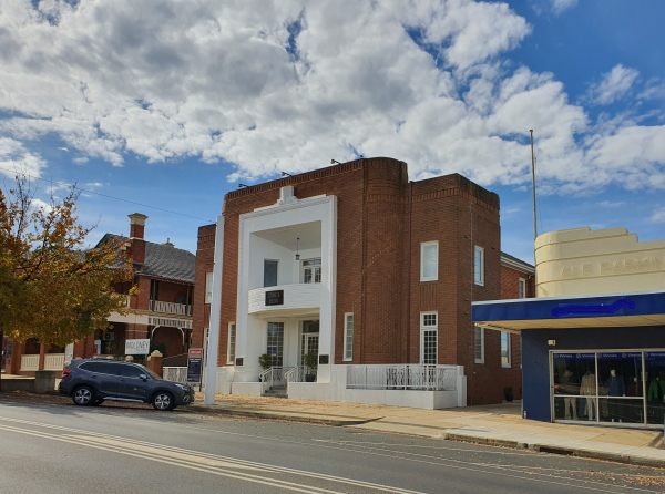
The Bank of Victoria building is located at the corner of Barkly and Foord Streets, and was built in 1874. It is no longer a bank, but is still an imposing structure.
The John Foord and John Crisp Memorial Cairn is at the south-east corner of Blanche and Foord Streets, and commemorates the initiative of these early settlers who arrived in the area in 1839 (the Memorial was erected in 1939).
The ornate School of Arts Building (Foord Street) was built in 1912, and provided an important focus for many community activities.
The Mass Tree is in Short Street, and whilst this is not part of the built environment, it has a memorial plaque commemorating the first mass conducted in the area, in the shade of this ancient river gum. The plaque gives the details of this notable event of 1869.
North of the border bridge, a walk down the main street of Corowa will show a great mix of archtectural styles, notably Art-Deco and Federation.
Equally as interesting, a turn to the north off Honour Avenue leads to the Corowa Whiskey and Chocolate Factory, a great place to purchase some wickedness and/or have lunch.
See also, the Wahgunyah History Trail brochure - available from Visitor Information Centres at Rutherglen and Corowa.
Walking Tracks
There are also a number of enjoyable walks in and around the two townships, and these are detailed in the Cycling and Walking Trail Guide brochure (available at the Visitor Information Centre in Corowa and Rutherglen). You can also download this brochure from the Corowa and Rutherglen VIC websites and northofthemurray.com.au (see below).
The pick of the crop from this brochure includes,
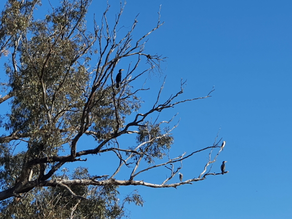
The Tommy McCrae Track [AWTGS-2] leads upstream from Wahgunyah (Barkly Street) and follows the river to Federation Bridge. Tommy was a local aboriginal elder, and several story boards along the pathway help share his, and his ancestor’s, knowledge of the area.
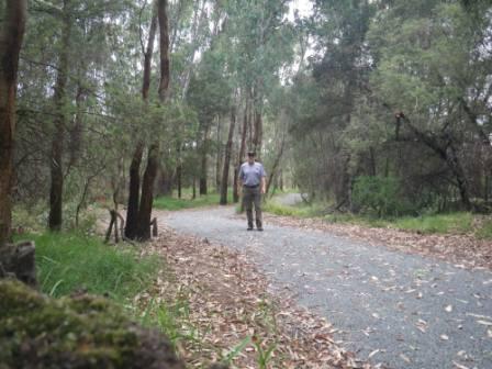
The track has a made surface all the way, and follows the River quite closely, so the scenery is good, with many waterbirds to be seen here and there. On the inland side of the track, there are several lagoons, and these also offer excellent opportunities for bird watching.
Walking time is about an hour each way, and the distance covered (one way) is about three kilometres. If you don't have the time to complete the six kilometre loop, you might want to organise a car shuttle, or call up a taxi from Corowa to get back to the start.
Tommy McRae was a renowned painter, and if you enjoyed this walk, you can see some more of Tommy’s works at the Federation Gallery in Corowa, and at the Benalla Art Gallery. The northern side of the Federation Bridge has been named Tommy McCrae Causeway in his honour.
The Willows Reserve Trail [AWTGS-3] (also known as River Trail) is an extension of the previously described Tommy McCrae Track.
Leading off from Short Street (a left turn just before the bridge, when heading to Corowa), follow the River Trail signs to a small parking area, and the walking track leads off from here.
You can follow this track downstream for about two kilometres, and then cut across to the Wahgunyah Recreation Reserve, and follow the track back to the start. Walking time is about one hour, and the distance covered is about four kilometres. As with the main part of the Tommy McCrae Track, there are several storyboards en route, and these provide for another enjoyable walk.
See also the Rutherglen Loops ; link below.
The Corowa Wetlands are just off the Riverina Highway (Honour Avenue), when heading east, and feature a bird hide, a shaded picnic area and several information boards. A walking track circles the wetland, and makes a nice leg stretch, with the chance to see a variety of birdlife.
The wetlands are a short drive from town (on the left) but it is nicer to take a short stretch of the bike path heading east, and then turn left at the water treatment plant.
Downstream of Corowa, the Corowa Common has a range of walking trails.
Access is via Hume Street, which runs off Federation Avenue, and then an unsealed roadway that runs alongside the Corowa Golf Club.
Alternatively, turn right onto Augusta Street (just before the Golf Club) and then take the left turn onto Neill Street.
Both of these access points are for use in dry weather only.
See the NorthoftheMurray website for basic details (link below).
Wineries in the Wahgunyah area include;
Distillery Road leads to Cofields Winery and its adjoining cafe. Frank Cofield, the great grandfather of the current owner, started working at St Leonards vineyard in 1909, and his offspring followed in his footsteps. Winery founder Max Cofield worked at Seppelts, and at All Saints, before deciding to set up on his own; the winery is now run by his son and family.
Further down Distillery Road from Cofields, Dinah Wines is operated by the well-known Buller Family, and is open for tastings, and wine sales, most days of the year.
Further down Distillery Road from Dinah Wines, Pfeiffers Winery is a long established winery, with the Pfeiffer Family having taken over in 1984. The winery is open for tastings, and wine sales most days of the year. The winery buildings, and the vines themselves, are split by a waterway known as Sunday Creek; the historic bridge being one of several locations in the North-east used for the World’s Longest Lunch.
The winery was originally built in 1895 by a French winemaker, a Monsieur Joseph Gassies. Joseph later accidentally drowned in Sunday Creek, and the winery then had several owners, including the noted Seppelt and Sons. After a long period of neglect, the winery was then rejuvenated by the Pfeiffer Family.
On Federation Way (the road leading to the NSW border),
All Saints Winery is well known for its imposing castle-like architecture, and its great food offerings. Vines were first planted here in 1864, and the original buildings (classified by the National Trust) were erected in 1880. Mey Castle, in far north Scotland, was reputedly the template for the main building.
St Leonards Winery, which dates from the 1860s, is on a bluff overlooking the Murray River, and has a popular dining area (indoor and outdoor).
RUTHERGLEN (includes Lake King and Wahgunyah Rail Trail)
Corowa Visitor Information Centre
Rutherglen Visitor Information Centre
Intro Screen on a fresh browser page
COPYRIGHT © 1995-2024, Chris McLaughlin.