RUTHERGLEN
(www.northeastvictoria.online)
Rutherglen is located about 50km north of Wangaratta (and about the same distance west of Albury-Wodonga) and was named after a township just south of Glasgow (Scotland).
It was first named Wahgunyah Rush (after the nearby river port of Wahgunyah; the word ’Rush’ referred to the gold rush that was underway at the time) but this was later changed to Rutherglen, when the new township started to eclipse the old.
Rutherglen (in Scotland) was the home town of local hotelier John Wallace, and the name change occurred when Wallace offered to shout everyone a free beer, in return for the privilege of choosing a new name for the town. Wallace went on to build, and operate, a chain of hotels all over the North-east, all of them named The Star Hotel.
There is a memorial to John Wallace, at the western end of Douglas Street, not far from the centre of town.
Interesting access routes to/from the town include
Like many townships of the North-east, gold mining provided much of the impetus for the establishment of the first settlements of the Rutherglen area, and as you enter the town from the west, there is a memorial obelisk at the junction of the Murray Valley Highway and the Wahgunyah Road commemorating the discovery of gold in the area in 1860.
The township grew rapidly during the gold rush days, with several big mining operations to be found close at-hand. The All England Mine produced 40,00 ounces of gold; Wahgunyah 37,000; Hibernian 35,000; Clydesdale 26,000 and the Robert Burns 22,000 ounces. The town’s population reached about 30,000 at the peak of the gold extraction period.
However, the gold mining is well into the history books, and Rutherglen has been noted as a premier wine growing area for almost 150 years, as well as a being a productive area for other forms of agriculture.
Expectedly, there are many wineries in the area, with several of these having been in existence for more than 100 years. Whilst the Rutherglen area produces a wide variety of excellent wines, the area is also renowned for its ports, muscats and topaques.
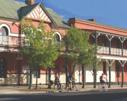
The town has an enviable streetscape, with many beautifully preserved buildings from the gold mining era, as well as the boom times of the late 1800s, and makes a good base for touring in this part of the North-east. Accommodation options include motels, hotels, B&Bs and a caravan park. Shops and services include a well-stocked supermarket and plenty of cafes.
Great places to eat in town include,
Pickled Sisters
Taste at Rutherglen
Thousand Pound Wine Bar
Valentines Bakery
Victoria Hotel
Things to see and do in the Rutherglen area include . . .
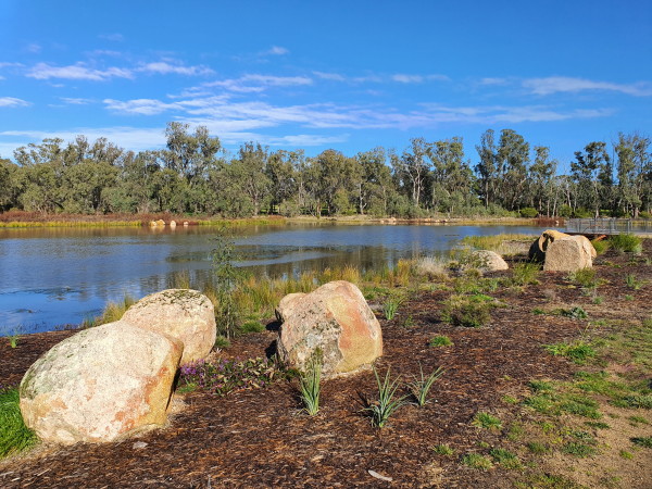
Lake King
Lake King is an artificial lake that dates from the gold mining era, and was formerly the water supply for the burgeoning township. In the modern era, the Lake has a 1.2km walking track around its perimeter, and this is a popular loop for locals and visitors.
Access is easy, with plenty of parking being available in Murray Street, and from here you can complete the loop in about 30 minutes. If you are staying at the Caravan Park, access is even easier, with the Lake being right on the Park’s doorstep.
The Lake was named after Daniel King, shire president at the time of the Lake’s construction, and is home to many water birds, and some impressive examples of river red gum.
The walking track is named after Arthur Mann, and provides a popular exercise routine for the town’s inhabitants and visitors alike. The walk takes up to 30 minutes, depending on your interests etc.
The lake has recently undergone a renovation, and the photograph shown is of the lake after this work.
Sculpture Trail
The Arts Rutherglen Sculpture Trail covers about 50km in its entirety, but it is easy to ‘pick-and-choose’ which ones you would most like to admire.
A full-colour brochure is available from the Visitor Information Centre for $2 (also available on-line), and this is a must-have guide to the trail. It lists all of the exhibits, along with photos, and location of each.
There are 12 sculptures within the township itself, one at Calico Winery, three at Gooramadah Olives, one at Jones Winery, four at Pfeiffer Winery, three at Scion Winery, one at Valhalla Winery, and one at the Wahgunyah Primary School.
Overall, a great community project - very interesting artwork, and a pleasing variety of venues. See the link below for more details.
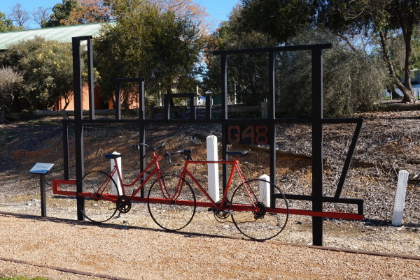
Rutherglen - Wahgunyah Rail Trail
The railway tracks have long since gone (the line was opened in 1879, and remained in service until 1962) but this rail trail certainly provides some enjoyment.
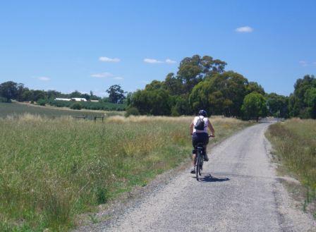
The rail trail is about nine kilometres long, and is one of the shortest bike pathways in the North-east.
The path taken by the Rail Trail is through fairly open country, so you will need plenty of water on a hot day; however there are no steep gradients, so this is a nice trip for all bikers.
The surface of the Trail is bitumenised, albeit gritty for most of its length.
The Trail starts at the former Rutherglen Railway Station (in Douglas Street, just near the Information Centre) not far from the main commercial street of the town, and some nice coffee shops.
Riding from Rutherglen to Wahgunyah
As you pull away from the former station, there are wheat silos to the right, and straight-ahead there is the only bridge on this route, and underpass of High Street.
Once clear of the urban area, vineyards soon appear, and the Trail passes around the back of Chambers Winery, with the ruins of the nearby Vidal Winery being clearly visible to the right.
Soon after this, the winery buildings of Calico Town Winery appear on the ridgeline to the right, with the nearby poppet head being clearly visible (see Winery Listing below).
On the way past these features, there are several relics from the gold mining era, with some stopes being visible to the left.
O’Donoghues Road is the next landmark on the Trail; this is an unsealed road, with a barrier system to ensure that riders slow down for this intersection. If you swing right (east) at this intersection, then it is a short up-hill ride to Calico Town Winery (see below).
Continuing towards Wahgunyah, there is another unsealed road to cross, again with a barrier system to ensure that riders slow down at this point.
As you approach Wahgunyah, Uncle Tobys Plant comes into view, and soon after this you need to cross over the C376 (Federation Way), where the road traffic will be travelling quite rapidly, and you need to allow plenty of room to get over safely. There is a length of railway track embedded in the bitumen at this point, and riders should take care to avoid getting narrow rims caught in this obstacle.
Passing around the rear of Uncle Tobys, the former Wahgunyah Railway Station site is encountered, and veering right in the midst of the site now leads to a t-junction at Sarah Street. Turn right here, and head down towards Barkly Street, where you need to turn left to get to the centre of town, and the John Foord Bridge, where the action finishes.
For a continuation of the enjoyment, you can keep straight-ahead at Barkly Street, and pick up the Tommy McCrae Walking Track.
This riverside track (which caters for bikes, as well as walkers) leads upstream from Wahgunyah, and follows the Murray River to Federation Bridge; more details from an information board at this point, and in the Wahgunyah description.
Riding from Wahgunyah to Rutherglen:
In the reverse direction to the description given above, all of the landmarks obviously appear in the reverse order. But wait - there’s more . . .
On the final approach to Rutherglen, there are many excellent views of the vineyards that cluster around the town, as well as some really nice glimpses of some of Rutherglen’s historic buildings. For example, the original town watertower (with its wine glass top) is clearly visible on the hill behind the township, as is the Mount Carmel Convent.
RUTHERGLEN LOOPS
This cycling route was formerly called the Rutherglen Wine Walk Cycle Trail, and when complete will provide a 48km mix of trails around the Rutherglen area, including access to several wineries.
See the Link below for the status of this project.
RUTHERGLEN WINE REGION
All Saints Estate, All Saints Road, Wahgunyah (has a cafe/restaurant)
02 033 1922, website
Anderson Winery, 13 Chiltern Road, Rutherglen
02 6032 8111, website
Andrew Buller Wines, 352 Jacks Road, Rutherglen
0413 332 956, website
Buller Wines, Federation Way, Rutherglen (has a cafe/restaurant)
02 6032 9660, website
Campbells Wines, Murray Valley Highway, Rutherglen
02 6033 6000, website
Chambers Rosewood Winery, Corowa Road, Rutherglen
02 6032 9641, website
Cofield Wines, Distillery Road, Wahgunyah (has a cafe/restaurant)
02 6033 3798, website
DeBortoli Wines, 13-35 Drummond Street, Rutherglen
02 6033 6100, website
Dinah Wines, 199 Distillery Road, Wahgunyah
02 6009 0213, website
Gehrig Estate Wines, 1326 Gooramadda Road, Gooramadda
02 6026 7296, website
Lake Moodemere Vineyards, Murray Valley Highway, Rutherglen
02 6032 9449, website
Lilliput Wines, Springhurst-Rutherglen Road, Lilliput
03 5726 5055, website
Morris Wines, Mia Mia Road, Rutherglen
02 6026 7303, website
Mount Prior Vineyard, Gooramadda Road, Rutherglen
02 6026 5591
Olive Hills Winery, 3221 Murray Valley Highway, Rutherglen
02 6032 9977, website
Pfeiffer Wines, 167 Distillery Road, Wahgunyah
02 6033 2805, website
Rutherglen Estates, 13-22 Drummond Street, Rutherlgen
02 6032 7999, website
Scion Winery, 74 Slaughterhouse Road, Rutherglen (has a cafe)
02 6032 8844, website
St Leonards Vineyard, St Leonards Road, Wahgunyah (has a cafe/restaurant)
02 6033 1004, website
Stanton and Killeen Wines, Murray Valley Highway, Rutherglen
02 6032 9457, website
Warrabilla Wines, Murray Valley Highway, Rutherglen
02 6035 7242, website
WAHGUNYAH (includes Tommy McRae Walking Track and Wineries)
WANGARATTA to RUTHERGLEN (via Black Swamp and Lake Moodemere)
Rutherglen Visitor Information Centre
Intro Screen on a fresh browser page
COPYRIGHT © 1995-2023, Chris McLaughlin.