STANLEY and the Stanley Plateau
(www.northeastvictoria.online)
Stanley is well known as a prime fruit growing area, producing apples, stone fruits, berries, walnuts and chestnuts. The area was first settled in the 1850s (during the gold rush era, when it was known as Snake Valley) and by 1856 the town’s population was more than 5000.
The village is accessible via Albert Street, and then Hodge Street (which is also known as the Stanley Road).
There are many historical points of interest in and around the township. Stanley School was first established in 1857 as an independent community school, the present building, which was constructed in 1872, is one of few brick school buildings of that era remaining.
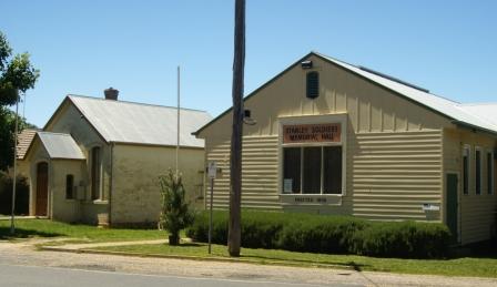
The Athenaeum was built in 1874 for use as a library and public meeting place and is classified by the National Trust and listed on the Australian Heritage Register. The Presbyterian Church, opened in 1865 (and used until 1942) is similarly classified by the National Trust, and listed on the Heritage Register.
At the other end of the life-cycle, the first recorded burial at the Cemetery was in September 1866, and there are many interesting headstones marking the passing of Stanley pioneering families.
Apart from historic buildings, Stanley also has a charming ambience. Park your vehicle and wander around, buy an apple and/or some other local produce, absorb some of the atmosphere, take some photographs and generally relax before moving on. The Hotel serves an excellent meal, with great ambience.
Other than orchard outlets, a post office cum general store, and the Hotel, there are no retail outlets in Stanley.
The Stanley Hotel was one of seven owned by John A Wallace from Rutherglen (in Scotland). Wallace operated a series of hotels in the North-east, all of them called The Star Hotel. A plaque outside the Stanley Hotel (formerly The Star Hotel) provides a biography of this interesting person who (amongst other things) gave Rutherglen (Victoria) its name.
Orchards and Pine Plantations
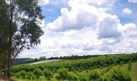
Many orchards in the Stanley and Beechworth areas date back to the gold rush days, when the suitability of the area (soil and climate) was found to be eminently suitable to apple production. Most of the orchards in the area have ’farm-gate’ sales, and these make popular destinations during the berry, cherry, apple and nut seasons.
Hillsborough Quality Nuts are on the Mount Stanley Road, as is Highgrove Orchard. As well as selling their nut produce, Hillsborough also sell other goodies, and offer a relaxing cup of tea/coffee with scones on their patio (great views as well).
Sinclair Cider and Apples are at the cross-roads in the centre of the village, and Maison Renoux (Apple Cider Vinegar) are a short distance away, in Thompson Lane.
Jim Jam Foods (chutneys and jams) are on Circular Creek Road (a sign-posted turning off the Myrtleford Road) and Snowline Fruits are on the left, a few kilometres from the centre of the village, and are also on the Myrtleford Road.
The pine plantations in the Stanley area were originally established during the Great Depression, using the vast pool of unemployed that were a feature of those times. The plantations were subsequently worked by overseas born interns (mostly Italians) during World War II, and are now in their third harvest cycle, the plantations having a cycle of about 30 years.
Mount Stanley (optional detour)
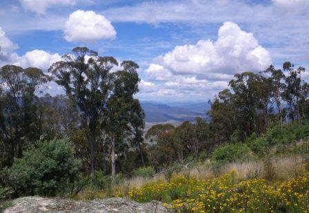
Stanley State Forest occupies much of the high country and plateau that clusters around Mount Stanley (1050m) and the drive to Mount Stanley is highly recommended for its great views of the surrounding alpine valleys and high country. The 17km (60 minute) loop described here is about 30% on bitumen, the rest on reasonably well graded forest roads; for safety reasons, this route is to be avoided during sustained wet weather, and on any super-hot days.
The tour starts by taking the signposted Mount Stanley Road from the centre of Stanley township; here a big green sign advises that it is eight kilometres to the Mount. It’s actually about 8.6km, but no matter the drive is still very enjoyable. Heading out of town, the route swings past the Nine Mile Diggings, the epicentre of much of the gold mining activity in the Stanley area in the 1850s; a story board on the right gives much of the historical notes on this era.
The bitumen runs out after about three kilometres (just after Walnut Road), with the scenery so far being dominated by rolling hill country, orchards and plantations.
Stay on this roadway (ignoring all of the side roads) until about the 4.3km mark, where a hard-to-see Mount Stanley Road signpost points to the right at a t-junction. This leads straight into Mount Stanley Scenic Reserve, and the pine plantations are now left behind. For the technically minded, this t-junction is at GPS 36:25.25s : 146:47.28e (degrees, minutes).
The roadway now meanders around the slopes for the next 4.3km, with great views off to the left, as well as a perfect native forest all around; this is mostly open forest, with an amazing floor cover of ferns.
There is a telecommunications tower complex on the actual summit of Mount Stanley, and this can be seen at several points of the ascent. Having arrived at the cleared ground in front of the towers (this is at the junction of Mount Stanley Road and Mount Stanley Jeep Track) there is a road swinging around to the right, and this should be followed until the picnic area comes into view.
There is only limited parking here, but it is right next door to a table and chairs setting, with amazing views down the valley towards Myrtleford and Mount Buffalo. For the technically minded (again) the picnic area is at GPS 36:27.06s : 146:48.14e (degrees, minutes) and is at an altitude of 1053m.
Starting the return down to the township, there are many different perspectives of the same landscape features that you saw on the way up, remembering to turn left at the t-junction referred to above.
Stanley to Myrtleford (optional access/egress)
The Myrtleford Road is a very scenic drive of about 24km, with most of the first 14km being through rolling hill country (orchard country) and then through a nice section of state forest. The roadway is sealed all the way, and is an interesting drive, with some great views of the valleys down below. A t-junction at the 14km mark, where you meet up with the Yackandandah - Myrtleford Road, requires a right turn, and from here the centre of Myrtleford is about 10km away.
Stanley on foot
Local Visitor Information Centres (Beechworth, Wangaratta and Yackandandah) have an informative brochure called Walking Stanley (link below) which details some nice walking tracks in, and around, Stanley township.
Beechworth Visitor Information Centre
COPYRIGHT © 1995-2022, Chris McLaughlin.