BENALLA - TATONG
STRINGYBARK CREEK - GRETA WEST LOOP
(www.northeastvictoria.online)
TRAVELLING TIME: Allow 4-5 hours.
DISTANCE COVERED: 160km.
OVERVIEW MAPS: RACV Kelly Country.
DETAILED MAPS: Rooftop Maps, Bright - Mansfield Adventure Map. The tour is also covered by the VicMap 1:50 000 maps Benalla and Samaria.
SHOPS and SERVICES: Benalla has a wide range of shopping, services and eateries; Tatong has a general store, and a hotel.
ACCOMMODATION: Benalla has a good range of accommodation options, including motels and some B&Bs. Further south, Lima East Road leads to James Camping Area, a large camping area alongside the scenic Lima East Creek. James has picnic facilities, a toilet block and lots of flat ground, so that even the biggest of crews will have no problem finding somewhere to set up their tents.
At Lima itself, the Midland Highway Park has powered sites, camping sites and cabin accommodation; more details at www.midlandholidaypark.com.au.
The Tatong Tavern (see below) also offers accommodation.
And (finally) if you have your camping gear with you, there are several opportunities for camping en route.
ROADWAY DETAILS: Mostly sealed road, with two runs of well graded gravel; no problems in dry conditions. There are some narrow roadways in the tour, and for this reason camper-trailers, caravans and motorhomes are not recommended on this route.
WHEN TO GO: Avoid wet weather, and any super-hot days.
OTHER INFO: This is a great drive with plenty to see and do. Distances quoted may vary by several kilometres from one vehicle to another. The main text describes the run to Tatong using the Midland Highway; see the additional description (after the main text) for a direct run from Benalla to Tatong, thereby bypassing Reef Hills and Swanpool.
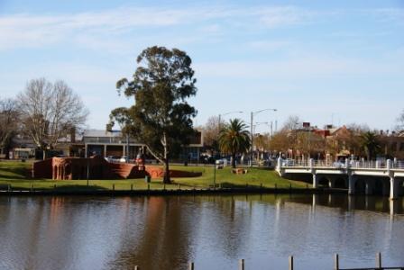
Starting off from the Monash Bridge in Benalla (with the tripmeter at zero), this enjoyable tour begins by heading for the Midland Highway (B300), and following this south, crossing over the Hume Freeway a short distance out of town. Alternative access is by taking the Midland Highway exit directly from the Hume Freeway.
Having left the Freeway behind, items of interest along this tour include . . .
Reef Hills State Park (optional detour)
Reef Hills State Park is located just to the south-east of Benalla, and is noted for its box-ironbark forest, a major remnant of this once widespread vegetation cover of northern Victoria. Access to the Park is by taking the Midland Highway exit from the Hume Freeway, and then heading towards Mansfield. The entrance to the Park is then about 200m clear of the Freeway ramp system, with the appropriately named Reef Hills Road providing access to the only formal picnic area in the Park.
As the Park’s name might indicate, Reef Hills is a former gold mining area, with gold being discovered in this area during the 1860s. Evidence of the gold mining can be found at several points around the Park, however the fauna and flora of the Park are just as interesting, and the Park is one of several areas of Victoria where the Box-Ironbark ecosystem is preserved.
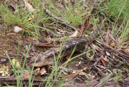
Several species of Box are found in the Park, including Grey Box, Red Box and Long-Leaf Box, all of which provide shelter for a range of wildflowers (very scenic in September), as well as a surprisingly wide range of birds and mammals.
Despite all these natural assets, one of the more popular pastimes in the Park is trail bike riding, and for this reason (unless you are a keen rider) the Park is usually best avoided on weekends, and during holiday periods. The Park is also a popular mountain biking and gold prospecting area.
More details are available from a downloadable PDF on the Parks Victoria website (see the link below). This shows the principal road network of the Park, as well as the location of the designated prospecting areas.
Back on the Highway, the small settlement of Lima is a short drive further south, and is home to the Midland Highway Park with its powered sites, camping sites and cabin accommodation; more details at www.midlandholidaypark.com.au.
Swanpool
Swanpool is a small community located about 40km north of Mansfield (20km south of Benalla) and has a small general store and a fuel outlet. Just before entering the township, one of many memorial cairns that celebrate the Hume and Hovell Expedition of 1824 is on the right-hand side of the roadway. Swanpool is also home to one of Victoria's last rural cinemas, a fascinating 1950s style cinema at that; see swanpoolcinema.com.au for screenings.
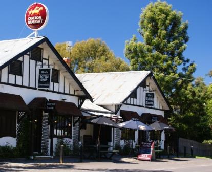
Tatong and The Tavern
Swanpool also provides access to the Tatong Tavern, with its renowned restaurant. Access from the Midland Highway is by turning east (left) at Swanpool, and following the signposts through to the township of Tatong.
This nice 15km drive leads over the Broken River, and through pleasing pastoral land to a t-junction where you need to turn left. This is followed by an off-set t-junction where you need to turn right for the final run to the environs of Tatong.
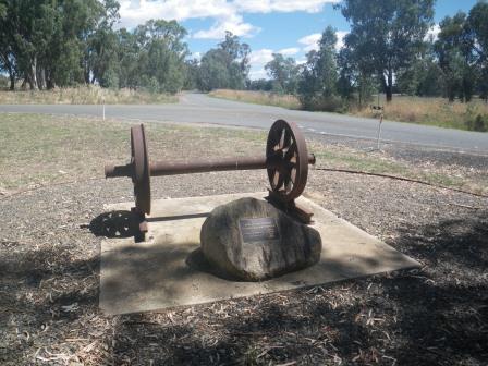
Tatong was served by a rail line from 1914 to 1947, and this scenic route ran from Benalla to Tatong via Karn, Lima and Mallum Stations. The railway station at Tatong was about one kilometre west of the township, and is marked by a replica station sign, clearly visible as you arrive in the town's environs. As this was the terminus of the rail line, the engineering works at this point included a turn-table so that the steam locomotive could be spun around for the return journey.
Just after the former railway station the route crosses Hollands Creek, with a nice rest area on the right (just after the bridge) that is sometimes used as an informal camping area.
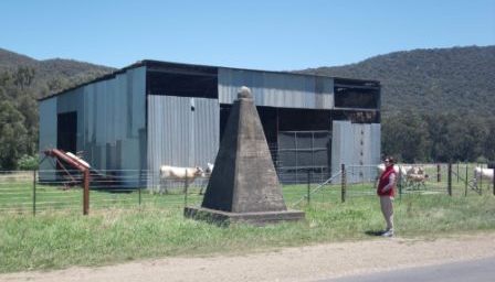
Once in the village of Tatong, the Tavern is easy to locate, being a distinctive tudor style building, with plenty of shade nearby.
The Tavern serves an excellent meal, and is a popular venue (bookings recommended).
There has been a tavern on this site since 1880; the original burnt down in the 1923 bushfires, and the present building dates from that year, with the ‘tudor look’ being added in about 1980.
More details of the Tavern, the restaurant, and the accommodation options can be found at www.tatongtavern.com (see useful links below).
See also the Tatong Heritage Group website (link below) for lots of interesting info on the area, including a heritage trail drive.
Hume and Hovell Memorial
Continuing on from Tatong, the main road running through Tatong is the C517, which runs from Tolmie to Benalla, and it is this road which the route now follows to the south (that is, towards Tolmie). Rural scenery is the order of the day for the first 14km, and then it is into the forested hill country.
On the way landmarks include several very pleasant roadside rest areas alongside Hollands Creek (at McCauleys Crossings, Dodds Bridge and Fords Bridge). On the right, between the latter two rest areas, there is another memorial cairn to the Hume and Hovell Expedition of 1824, one of many such memorials throughout the North-east.
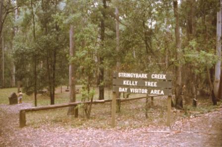
Stringybark Creek
The bitumen is left behind as the C517 enters the forest but the surface is usually very good, albeit loose and sinuous. The Toombullup Historic Area soon comes into view, as does the signposted right turn to the Kelly Tree Picnic Area and the nearby Stringybark Creek Camping Area. Both of these places are popular during holiday periods, but out of those times are very tranquil.
As mentioned in the section on Bushrangers, in 1878, after a few incidents and misunderstandings, the police decided to hunt for the Kellys, who by now had been joined by Joe Byrne and Steve Hart. The gang heard news of this and decided to fight fire with fire. The Kellys crept up to the police camp at Stringybark Creek in October 1878 and ordered the officers there to surrender their arms and, in the ensuing shoot-out, three police officers were shot dead.
After this incident, the Kellys rode into Euroa on 11th December and robbed the National Bank. This daring robbery was followed by the hold-up of an entire town, Jerilderie in New South Wales. The Kellys held the town for three days before returning to their hideout at Greta in the King River Valley.
Just prior to the Kelly Tree turn-off, Madhouse Road goes off to the left, and leads after about 500m to the grave of Frances Cryer. There are not many obvious grave sites out in the bush, but this is one of them; a memorial plaque at the site explains how Frances came to be buried here, rather than in Tolmie or Mansfield, as would have been the norm in the late 1880s.
After leaving the Kelly Tree, continue along the C517 to a t-junction with the C521 (the Mansfield - Tolmie - Whitfield Road). The township of Tolmie is to the right at this junction, whereas Whitfield is to the left. As mentioned in the tour header, Tolmie has a small general store, and a neat country pub, and is worth the small detour if you need to stock up on any goodies.
Powers Lookout
Continuing on, the road meanders through the forest, with patches of cleared land, and apart from the great scenery, there is also a short walk with historical links to the bushranger era, at Powers Lookout. The Lookout is located about five kilometres off the main road (to the right) and makes an interesting side-trip.
Powers Lookout was supposedly used as a lookout by bushrangers in their efforts to evade pursuit by police and troops, and has superb views over the King River Valley. Picnic and barbeque facilities are provided at the car park and from here a short stroll leads to the edge of a large rocky outcrop. This is Lookout #2 which has an excellent vista that includes a patchwork of farms set along the King River. In spring the yellow wattle blooms stand out against the background of greens and greys.
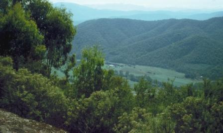
A further short walk (30 minutes) leads off from the car park to the actual Lookout (that is, Lookout #1). The view here is from a different angle and is well worth the short walk.
Back on the main road, there are many more great views to enjoy, before starting a steepish descent down towards the Myrrhee turn-off (to the left).
Myrrhee
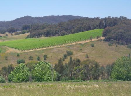
The turn-off to the small village of Myrrhee leads into a partially unsealed route (of about seven kilometres) but is usually quite well graded. Myrrhee is a noted hop growing area of Australia, and on the descent to the township there are great views of the Upper Fifteen Mile Creek Valley. You need to veer right at about four kilometres after leaving the bitumen, and once in Myrrhee there is a t-junction, with Benalla (and the main part of village) being to the left, and Boggy Creek Winery to the right.
Return to Benalla
From Myrrhee, take the signposted Benalla Road, and follow this down to the floor of the scenic 15 Mile Creek Valley. On the descent there are many great views of the valley down below, and this leads to a y-junction (16km from Myrrhee) where Moyhu and Wangaratta are off to the right, and the route to Benalla is basically straight-ahead.
Continuing down the valley, Great South is encountered a few kilometres later, and here you need to follow the main stretch of bitumen around to the left (that is, ignore the right turn signposted ’Benalla via Lurg’.
It is now an easy run of about 24km back to the environs of Benalla, coming into town via the Kilfeera Road - Tatong Road roundabout, a short distance east of the Old Hume Highway (Bridge Street) just north of the CBD.
[For a shorter version of this tour (about 140km overall), you can start off at the roundabout referred to in the previous paragraph. This gives you a direct run to Tatong (about 25km away), bypassing Reef Hills and Swanpool. From the Tatong Tavern the description is the same as before.]
KING VALLEY (Wangaratta, Whitfield, Lake William Hovell, Paradise Falls)
Parks Victoria (Reef Hills) website
Intro Screen on a fresh browser page
COPYRIGHT © 1995-2020, Chris McLaughlin.