KING RIVER VALLEY
(www.northeastvictoria.online)
TRAVELLING TIME: 3-5 hours, depending on your interests.
DISTANCE COVERED: up to 150km, depending on your interests.
OVERVIEW MAPS: Touring map of Victoria.
DETAILED MAPS: None required.
SHOPS and SERVICES: Wangaratta is the closest main commercial centre to the start of this tour, and offers a wide range of shopping and services.
Once in the King Valley, there is a general store, a cafe, a hotel and a fuel outlet at Moyhu; a general store, a hotel, cafes and a fuel outlet at Whitfield, and a cafe/bakery and general store at Cheshunt.
ACCOMMODATION: Caravan parks (and a range of other accommodation options) at Wangaratta; caravan park at Moyhu; bush camping at Edi Cutting; caravan parks (and motel units) at Whitfield.
There are also many boutique accommodation options in the King Valley.
The two caravan parks at Whitfield are Gentle Annie (alongside the King River), and Valley View (which is in town). The former has a nice riverside ambience, whereas the latter has a great position in the township itself.
WHEN TO GO: Anytime, so long as there are no flood warnings for the King River.
ROADWAY DETAILS: Bitumen all the way, albeit a little narrow after Cheshunt.
OTHER INFO: A fascinating part of Victoria, great scenery and plenty to see and do. Distances quoted may vary by several kilometres from one vehicle to another.
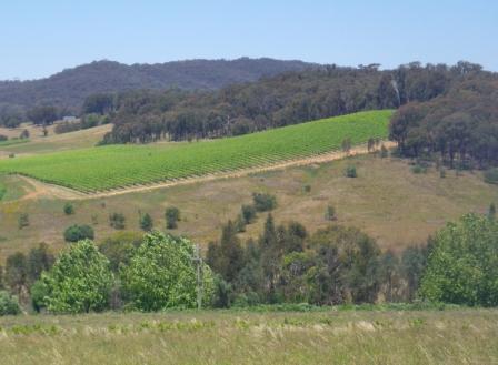
See the Wineries listing on the HomePage for more details on the wineries referred to in the text.
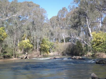
The King River is a major tributary of the Ovens River, and joins the Ovens close to the heart of Wangaratta (the confluence of the two rivers can be found by strolling through Merriwa Park, and then Kaluna Park).
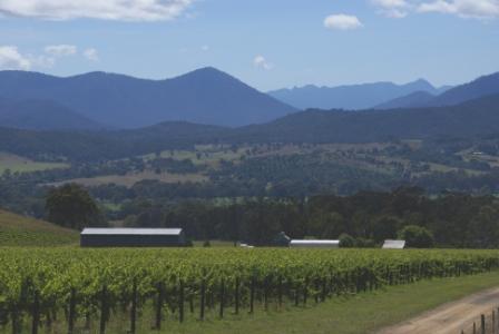
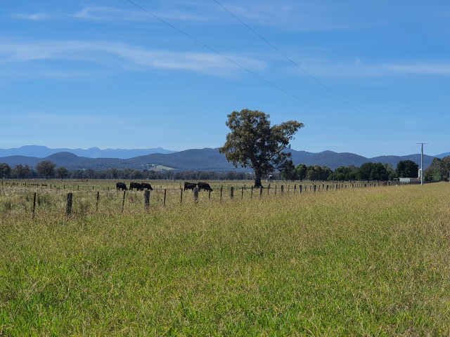
The King rises north of Mount Buller, west of Mount Speculation, and in its upper reaches offers a combination of waterfalls, mountain streams and rugged bushland. In its middle and lower reaches the King has created a very scenic valley, with great mountain scenery on both sides, and a perfect floodplain in the middle.
Explorers Hume and Hovell (see ‘Exploration’ on the HomePage) passed through what is now known as the King Valley in 1823. Hume named the Valley after another explorer, Phillip Parker King; Phillip was the only official son of the former New South Wales Governor, Phillip King, and explored much of Australia’s northern coastline.
There is easy access to the King Valley from many parts of the North-east, however the route described here starts from the intersection of the Snow Road (C522) and the Wangaratta - Whitfield Road (C521) south of Wangaratta.
With the tripmeter set at 0.00 at this intersection, items of interest along the way include . . .
Moyhu
The village of Moyhu comes into view after about 15km, and has a cafe, a general store, a hotel (home to Merkel Wines) and a fuel outlet, as well as an enjoyable caravan park.
The cafe (Ineeta’s) is a great place to stop for morning tea or lunch.
A small reserve at the cross-roads has a memorial to those brave people of the area who served in WW1 and WW2; the adjoining picnic area and toilets makes for a nice rest area.
Moyhu is also home to a once a month Farmers Market; details of this, and other, Farmers Markets are on the HomePage.
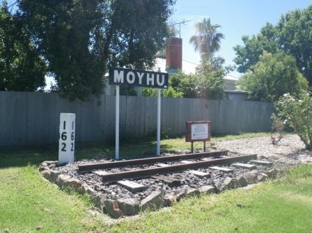
About two kilometres after the village, a y-junction points right to Boggy Creek Winery and Myrrhee, and left for Whitfield. This junction was once home to the Angleside Station of the King Valley Railway, and the platform marker is still there for all to see, one of many such markers on this route. See the Railways section on the HomePage for more details of this, and other railways of the North-east.
Angleside is also home to one of many memorial cairns to the Hume and Hovell Expedition; as mentioned above, see the Exploration section on the Homepage for more on Hume and Hovell.
Continuing towards Whitfield (see below the main text for more on the Myrrhee area) it is about 2.5km to the former Claremont Railway Station, and about another two kilometres to Dwyer Station.
Edi Cutting
The small settlement of Edi is encountered at the 22km mark, with a nice rest area (on the left) as you enter the settlement. The rest area has river frontage, with tables, chairs and plenty of shade, making for a nice morning tea stop.
King Valley Estate Winery is diagonally opposite the rest area, and is a noted leader in the production of biodynamic wines.
Just beyond Edi, an unsignposted (and unsealed) slip road to the left leads to Edi Reserve, a popular camping area on river flats alongside the King River. There are many excellent campsites here, with toilet facilities being provided at each end of the Reserve.
Expectedly there is plenty of shade, and it is easy to avoid the neighbours, and to claim your own section of river beach. The Reserve continues for about a kilometre, and reappears further down the Whitfield Road, again at an unsignposted intersection.
If you by-pass the Reserve (the path of the former King Valley Railway), the roadway now climbs up on the side of a ridge, passing through an area known as Edi Cutting.
Just beyond here, Red Feet Winery is off to the right, and then (on the left) "Riverside King Valley" offers full amenity camping alongside the King River (see their website for details, riversidekingvalley.com.au).
The former Hyem Railway Station is next, with La Cantina Winery being a right turn a few kilometres beyond the station signage.
Jarrodd Railway Station is about three kilometres up the Valley from Hyem, and in the same area, Gracebrook Winery is a right hand turn; the Winery has a great location on a hillslope, making it a popular venue for a relaxing lunch.
Just beyond the turn-off to Gracebrook, King Valley Brewery is on the left - another popular place for lunch.
Whitfield
The busy village of Whitfield is encountered at about the 37km mark, with the turn-off (to the left) to the Gentle Annie Caravan Park being just prior to the village. Gentle Annie has been around for a long time, and is a popular base camp for anglers, and white water kayakers.
Prior to the village, King Valley Brewery is on the left, and Dal Zotto Winery is on the left as you enter the village, and is noted for its excellent wines and restaurant.
As mentioned in the section header, Whitfield has a general store, an excellent hotel, cafes, a fuel outlet, a caravan park and motel units, with several B&Bs and holiday cottages adding to the accommodation mix.
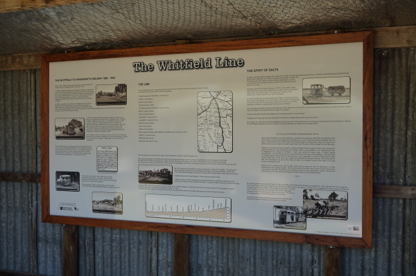
Taking it slowly through the village, there is a very informative storyboard on the right (adjoining a small rest area) that provides a detailed account of the King Valley Railway.
About 100m past this, the scenic Mansfield - Tolmie - Whitfield Road enters the roadway from the right, and is described separately; see the Homepage for details. This junction is just near the Mountain View Hotel, a place renowned for its great ambience and good food.
Continuing south from Whitfield, Pizzini Wines are on the left at 40km, a popular stop-over where the attractions include a good range of wines, and cooking classes.
Cheshunt
The small settlement of Cheshunt is not far beyond Pizzini Wines, and is encountered at about the 37km mark. Cheshunt also has an excellent bakery/cafe, a general store and a fuel outlet.
The bakery/cafe (The Oven at Cheshunt) is licensed and serves a great meal/snack from Wednesday to Sunday, and also sells products from the nearby Boonderoo Farm.
Opposite the bakery, the Cheshunt Hall is home to the memorial trees that commemorate Caroline Ennis and Dorothy Elmes; both were nurses stationed in Singapore in 1942. Caroline died in the bombing of the Vyner Brooke, and Dorothy was caught up in the Bangka Island massacre.
Just beyond Cheshunt there is a cross-roads, with the straight-ahead option leading to Paradise Falls (see below) and the right turn option leading to some more wineries and Lake William Hovell.
Dealing with the wineries first; Politini Wines are on the left, about one kilometre from Cheshunt; Chrismont are on the left at about two kilometres (excellent restaurant); Primerano are on the right at five kilometres, and finally Francesco are on the left at 11km.
On the way to all of these wineries, the scenery will have been excellent, with the occasional glimpse of the King River East Branch (the West and East Branch merge just downstream of here).
King River Camp (about 52km from the start) is just over the last bridge over the King River, a comfortable place to stay for family and/or school groups.
Lake William Hovell
The environs of Lake William Hovell are reached at about the 57km mark, with the main car parking area being encountered at about 59km. This scenic lake was completed in 1971, and was named after the great explorer William Hovell, who was 2ic to Hamilton Hume.
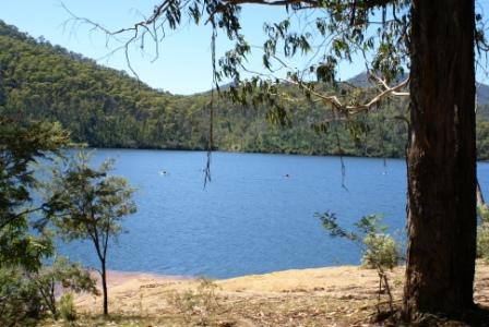
There are several memorials to Hume and Hovell throughout the North-east, most are bluestone obelisks, so Lake William Hovell is quite a different style of memorial.
Although quite small, the Lake has an interesting shoreline, with wooded hills, and some cliff faces rising abruptly from the waterline.
There are several picnic-barbeque areas on the lakeshore, which also provide convenient boat launching spots. Camping is not permitted anywhere around the Lake.
Paradise Falls
Paradise Falls make an interesting side trip from the King Valley, and are a series of spectacular u-shaped waterfalls on Stony Creek, a tributary of the King River.
The Falls are on the northern side of the Wabonga Plateau, with vegetation being dominated by open forest of narrow-leafed and broad-leafed peppermint and messmate, with accompanying grevillea, wattles, grasses and ferns. As in many similar areas of the Alpine National Park, there are excellent wildflower displays in this area during springtime.
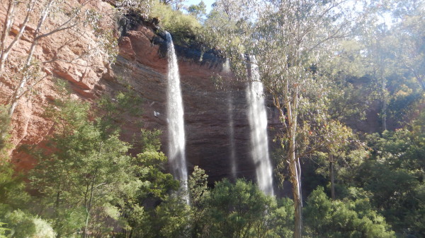
From Cheshunt, access to Paradise Falls is via the Rose River Valley (Dandongadale) Road east from the township, with the access road to Paradise Falls being about two kilometres away. The turn-off to the Falls is clearly signposted, and requires a right turn.
From the turn-off, the meandering access road leads to a car park, and picnic area, set in an area of dry, open forest, with no inkling of the moist, spray filled gully a short walk away.
At the end of the access road, the walking track to the Falls is signposted from the car parking area, and winds its way through open forest, gradually descending off the plateau, to meet with Stony Creek, and its secluded waterfalls.
There are two major falls here, both quite similar with each watercourse having cut a semi-circular arc through conglomerates and sandstones. This has created an extensive overhang in each case and it is quite easy to walk or sit under the waterfalls, and take a refreshing shower every few minutes.
The return to the car park is via the same route, and after the walk it is pleasant to take advantage of the picnic-barbeque facilities near the car park.
Myrrhee
From Whitfield the return home is normally by retracing ones steps, back up the C521. However, if you take the Mansfield Road from Whitfield, it is quite easy to vary the homeward journey by taking in the small settlement of Myrrhee.
Taking the Mansfield Road out of Whitfield, the roadway soon begins to climb into the forest, and the sign-posted turn-off to Myrrhee is encountered about seven kilometres away. Veering right here (with care) it is a short run of about seven kilometres (on a partially sealed road) to Myrrhee, a noted hop growing area of Australia.
On the descent to Myrrhee there are great views of the Upper Fifteen Mile Creek Valley, and you need to veer left at about four kilometres after leaving the bitumen. Once in Myrrhee there is a t-junction, with the village being to the left.
If you turn right, the roadway leads to the Wangaratta - Whitfield Road, emerging at the former King Valley Railway Station of Angleside (see main text). This is a nice drive, being very scenic and sealed all the way.
On the way there is a small parking area just beyond Bone Lane, and this bush track leads (on foot, or via a vehicle) to a very scenic valley.
It is a short distance to where Fletchers Track goes of to the left, and this takes you into a nicely secluded valley, noted for its springtime wildflowers (Fletchers Track is shown as Fletchers Lane on some maps of the area).
Continue along Fletchers Track to a t-junction, and then return via the same route.
Back behind the wheel, and continuing on from Bone Lane, it is about 6.5km to the Wangaratta - Whitfield Road.
Return to Wangaratta via Greta Road
For an alternative run back to Wangaratta, you can turn left (west) at Moyhu during the run back up the C521 to Wangaratta. Follow this sealed road through to Greta, and then turn right (north) at the Greta cross-roads for an undulating roadway back to Wangaratta, with nice views of the Warby Ranges to the left, and the high country to the right.
Take care at the Snow Road intersection (an off-set cross-roads), cruise over the Hume Freeway at a fly-over, and arrive just south of the CBD via Greta Road, and a set of traffic lights. This is a nice alternative if you have driven the C521 a few times, with Moyhu being about 27km from Wangaratta via the main road, about 35km via Greta Road.
Return to Glenrowan and the Hume Freeway
Another alternative on the home run, is to head for Glenrowan. This can easily be achieved by keeping straight-ahead at the Greta cross-roads, and following the bitumen through to an overpass of the Freeway, and then turning left for Glenrowan, or right for Wangaratta. In either case, this is a scenic run, with many good views of the southern ramparts of the Warby Ranges as you approach the Freeway.
Access via Meadow Creek
An alternative start to this route is by driving through Oxley, and then taking the Meadow Creek Road, sign-posted to the right just as you leave the village.
This leads past John Gehrig Wines, and then the Oxley Common (bush camping) before leaving the bitumen behind for a scenic run to the eastern side of Moyhu.
This is the road less travelled, with great views of the King River floodplain, as well as the alpine high country that forms a major part of the King River catchment.
The distance covered by this option takes 24km to get to Moyhu, versus 15km via the direct route described above.
Given the extensive stretches of gravel roadway, this option is not entirely suited to sedans, SUVs and AWD vehicles cope with the rough surface much better.
Some landmarks . . .
ignore the left turn to the Hurdle Creek Distillery (save that lovely experience for another day).
keep straight-ahead at the first cross-roads (at a give-way sign).
keep straight-ahead at the second cross-roads.
turn right at the third cross-roads, taking you back on the bitumen for a short drive to Moyhu.
turn left at the Moyhu cross-roads for Whitfield (Moyhu town centre is to the right).
BENALLA - TATONG -STRINGYBARK CREEK - GRETA WEST LOOP
MANSFIELD to the KING VALLEY (via Lake Nillahcootie, Tatong, Stringybark Creek and Powers Lookout)
ROSE RIVER VALLEY (Myrtleford, Lake Buffalo, King Valley)
Intro Screen on a fresh browser page
COPYRIGHT © 1995-2024, Chris McLaughlin.