CHILTERN
(www.northeastvictoria.online)
The first Europeans to document what is now the Chiltern area, were the explorers Hume and Hovell in 1824. Following on from this epic, several squatters took up land in the area in about 1838.
At this time the settlement was known as Black Dog Creek, or New Ballarat, and was very much an informal community. However, in 1858, in response to a growing population, and the separation of Victoria from New South Wales, Assistant Surveyor Thomas Wedge made a township reserve at the present site of Chiltern (the township was ultimately named after the town of the same name in the west of England).
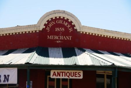
The establishment of the township (albeit in name only) encouraged many more settlers (pastoralists) to enter the area. The pastoralists were followed fairly quickly by gold miners, and mining operations in the area continued until the early 1900s. Gold was first discovered in the area by John Conness, hence the name of Chiltern’s principal business street.
At the height of the gold driven boom, the population of Chiltern was about 2200, and the township had all the hallmarks of a gold mining town in its heyday; banks, hotels and brothels were two-a-penny, and this was life in the fast lane.
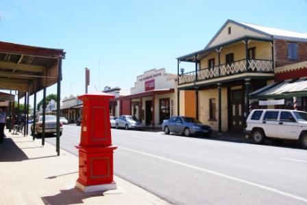
With the cessation of gold mining, the town settled down to a more sustainable economy, and present day visitors can wander around the downtown area, and admire the gold rush era buildings, with items of interest including . . .
Athenaeum Library & Museum (Conness Street); erected in 1866, this National Trust classified building houses many memorabilia of interest, including the Alfred William Eustace Art Collection. Eustace was one of the early settlers of the Chiltern district, and was a noted artist; in particularly he was noted for his ability to paint a landscape on a gum leaf.
See the link below for more information on this excellent museum.
The John McEwen Annexe of the Museum has many items of memorabilia relating to Sir John McEwen (born in Chiltern, 1900; died in Melbourne, 1980). During his colourful political career, McEwen became known as Black Jack McEwen, and was sworn in as the 18th Prime Minister of Australia, after the disappearance of Prime Minister Harold Holt in 1967. Approaching 68 at the time, McEwen was the oldest person ever to be appointed Prime Minister.
[Black Jack was renowned for his advocacy of protectionism for Australian agriculture, and manufacturing industry. When he retired (in 1971), McEwen had been a member of federal parliament for over 36 years, and was the last serving parliamentarian from the Great Depression. By the time he died, the Fraser government was initiating the abandonment of McEwenite protectionism, a process that continues today.]
Dow's Pharmacy (Conness Street); established here in 1859, the present building was erected in 1868.
Federal Standard Office (Main Street); erected in 1860-61; the Federal Standard and Ovens Tribune newspapers were printed here. Many of the printing presses etc are still on display at this venue. See the VIC for details.

Lake View (Victoria Street), the childhood home of Henry Handel (Ethel Florence) Richardson whose works include The Getting of Wisdom and The Fortunes of Richard Mahony. Lake View (a National Trust property) is the house used in the novel Ultima Thule.
Star Theatre and Grapevine Museum (on the corner of Conness Street and Main Street); built in 1866, this building is classified by the National Trust, and is home to a grapevine planted in 1867.
The Australasia Bank (Conness Street) built in 1879, this is now the Mulberry Tree Cafe, using the old banking chamber as a dining room.
All of these buildings, and many more, are shown, and described, in the Chiltern Walk section of the Chiltern Touring Guide, available from the Chiltern VIC, and other VICs in the North-east.
Accommodation options in town include a motel, a caravan park and several lodge and B&B style cottages in, and around, town; the Chiltern VIC has more details.
See also the separate descriptions of Chiltern - Mount Pilot National Park, as well as the driving tour of the Park (links below).
Good places to eat include "PoshPlonk" and the "Ironbark Tavern" (links below).
Chiltern Walking Path [AWTGS-2]
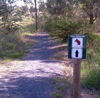
The Walking Path that loops around the central part of Chiltern township is the result of a community project starting in 2009, and finishing in 2011, with much of the work being undertaken by the local Lions Club and Landcare Group.
The Path is in three sections, each of which links in with the next section, so that you can complete them all in one session, or mix and match to suit the occasion. A colour map of the Walking Path is available for collection from the Chiltern VIC (see link below).
A key feature of the Path is that is basically follows the line of some minor urban waterways, and includes such interesting places as Black Ball Mine Dam and Lake Anderson.
All of the signage features a logo of the yellow footed antechinus, a small marsupial mouse that is endemic to the Chiltern area.
Overall distance is about three kilometres, with each section being about a kilometre in length.
Allow at least an hour to complete the full distance.
Access to Chiltern
All of the easiest access routes into Chiltern both utilise the Hume Freeway. The first of these involves taking the Chiltern - Yackandandah exit from the northbound, or southbound, side of the Freeway. From the exit turn west (left when heading north, right when heading south) and follow this route through to the centre of town.
A similar result can be achieved by taking the Barnarwartha exit from the northbound, or southbound, side of the Freeway; this exit being about 10km north of the Chiltern - Yackandandah exit. From the exit turn west (left when heading north, right when heading south) and follow this route through to the small village of Barnawartha. Turn left at the roundabout, and follow this scenic route through to Chiltern.
CHILTERN - MOUNT PILOT NATIONAL PARK
CHILTERN - MOUNT PILOT NP SCENIC DRIVE
Athenaeum Museum
Chiltern Bush Biking
Chiltern Visitor Information Centre
Henry Handel Richardson Society
Parks Victoria website
PoshPlonk
Ironbark Tavern
Intro Screen on a fresh browser page
Go Back to Menus
Go Back to SiteMap
COPYRIGHT © 1995-2025, Chris McLaughlin.