GLENROWAN
(www.northeastvictoria.online)
The Glenrowan area was first settled in the 1840s (by the Glenrowen family) and the settlement was given township status in 1861. The arrival of the railway in 1873 (taking advantage of a natural cutting through the ranges) was a major impetus for economic growth in the area, and the railway cutting (just south of the township) was to set the scene for one of Australia’s most well known shoot-outs, that of the Kelly Gang.
The easiest access route into Glenrowan is via the signposted exits from the Hume Freeway, either from the northbound, or southbound, side of the Freeway. From the exit turn west (left when heading north, right when heading south) and follow this route through to the centre of town.
From Wangaratta, take the old Hume Highway south, and then swing right, onto the Taminick Gap Road, just before the Freeway entry ramp. This then parallels the northbound lane of the Freeway for a few kilometres, before arriving at the town centre.
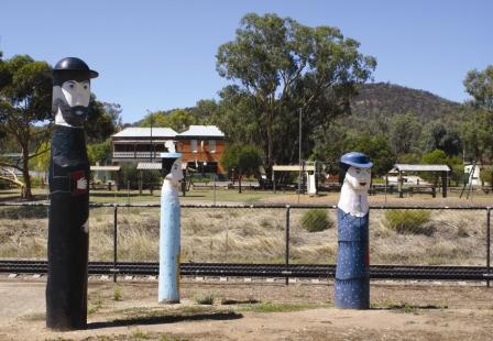
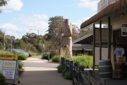
Present day Glenrowan is well known as the heart of Kelly country, and certainly has a wide range of memorabilia to choose from, all of it very well presented. Accommodation options in town include the Glenrowan Bushland Caravan Park, a nice quiet location that is a nice bike ride from the centre of town.
As well as the Kelly Memorabilia (which is centred on the main street - the Old Hume Highway), it is also worthwhile crossing over the railway bridge to have a look at Siege Street, the very place where the shoot-out took place. Kate’s Cottage has a good display of Kelly memorabilia, and a replica of the Greta West home of the Kelly’s, as it would have been in the 1860s.
Other attractions in the Glenrowan area include some excellent wineries; for example Baileys, one of the oldest wineries in Australia, Auldstone and Booths Taminick Winery; see the Wineries Listing for more details.
See the Warby Ranges Loop description (link below) for details of more things to see and do in the area.
The Kelly Gang
Sean Ceallaigh (John Kelly) was transported to Van Diemens Land (Tasmania) in 1841. John married Ellen Quinn in 1850, and they had six children; having lived in Wallan, Bendigo and Beveridge, they eventually settled at 11 Mile Creek, near Greta, just south-west of Wangaratta.
The Kellys had a few brushes with the law, and in 1871 Ned Kelly was sentenced to three years’ imprisonment (at the age of 16) for horse stealing. He served part of his sentence in Beechworth Gaol.
Jim Kelly was also sentenced for horse stealing, and upon release went to New South Wales where he soon received a further 15 year sentence. Dan Kelly, the youngest son, had his brush with the law in 1876, when he was sent to gaol for three months.
After a few incidents and misunderstandings, the police decided to hunt for the Kellys, who by now had been joined by Joe Byrne and Steve Hart. The gang heard news of this and decided to fight fire with fire. The Kellys crept up to the police camp at Stringybark Creek in October 1878 and ordered the officers there to surrender their arms and, in the ensuing shoot-out, three police officers were shot dead.
After this incident, the Kellys rode into Euroa on 11th December and robbed the National Bank. This daring robbery was followed by the hold-up of an entire town, Jerilderie in New South Wales. The Kellys held the town hostage for three days before returning to their hideout at Greta in the King River Valley.
Rewards were now being offered by the respective colonial governments, and various banks, for the capture of the Kelly Gang. However, the ensuing months proved remarkably quiet.
In June 1880 Dan Kelly and Joe Byrne went to the Woolshed Valley (north of Beechworth) to confront Aaron Sherritt, allegedly a police informer. Whilst Kelly and Byrne were riding to Sherritt’s home, Ned Kelly and Steve Hart travelled to Glenrowan. There they forced a rail maintenance gang to take up the tracks so that the police, alerted and on their way north for a showdown, would be blocked from the town. However the police managed to reach the town’s environs, and a major shoot-out ensued, leaving Dan Kelly and Steve Hart dead, and Ned Kelly badly wounded.
Ned was taken initially taken to Benalla, then to Beechworth, and finally to Melbourne, and after a brief trial was sentenced to hang on 11th November. Despite a petition of 32 000 signatures calling for the death sentence to be commuted to life imprisonment, Kelly was hanged, and the bushranging era was mostly over.
Famously, from the dock Kelly said ’I dare say that the day will come when we shall all have to go to a bigger court than this’ and moments before the hanging Kelly said ’such is life’.
Kelly’s prophesy about a ’higher court’ was to ring true; within two weeks, the judge (Redmond Barry) was dead, albeit from natural causes.
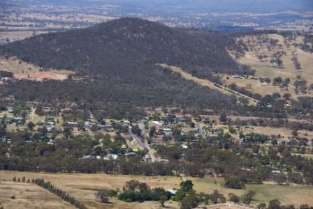
Mount Glenrowan [AWTGS-3]
Mount Glenrowan is the highest point for many kilometres around, and was (reputedly) a haunt of the Kelly gang, and certainly offers an advantageous view of the surrounding landscape. The lookout near the summit was named Morgans Lookout, after a member of the Kelly Gang.
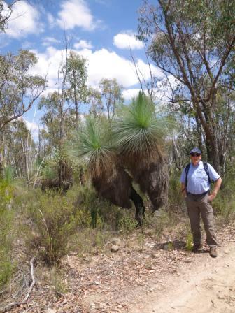
The walking track to Mount Glenrowan covers about 9.5km of interesting terrain, with the return trip taking up to three hours. The track is mostly undulating, however there is an initial steep section to gasp your way up.
Access is via the Taminick Gap Road, just north of Glenrowan, with the walking track to Mount Glenrowan (Ridge Track) being clearly signposted (there is a small picnic area on the opposite side of the road at the same place).
Setting out on foot, you need to swing right just before the first telecommunications tower, and follow the gravel for the next 60 minutes to Mount Glenrowan and Morgans Lookout.
Views are excellent, with the Winton Wetlands (Lake Mokoan) being visible to the right on the outgoing section. This is followed by many nice views of the floodplain, way down below, with the mosaic caused by different land usages being quite noticeable.
Ignore all of the side tracks, and follow the main pathway of gravel all the way to the second telecommunications tower, and then walk around this structure to the right, to get to the main lookout area.
Expectedly, the views are really excellent, with Mount Buffalo being clearly visible, along with much of the northern side of the high country, as well as the township of Glenrowan, neatly laid out down below.
The geographical significance of the siting of Glenrowan is also apparent from up here, with the township clearly dominating a major gap in the ranges.
Intro Screen on a fresh browser page
COPYRIGHT © 1995-2020, Chris McLaughlin.