WANGARATTA
(www.northeastvictoria.online)
Wangaratta is located in the heart of Victoria’s North-east, and has become its main commercial centre. Having started out as a remote river crossing in the 1830s, Wangaratta has developed into a very pleasing riverside city of about 18,000 people, providing goods and services to a large (and diverse) area of river valleys, flood plains and mountains; from ski resorts to wineries to textiles.
OVERVIEW
The Wangaratta area was originally explored and inhabited by the Pangerang People who, typical of many aboriginal groups, had a hunter-gatherer lifestyle that was eminently suited to the broad expanses of the King and Ovens River floodplains. Like every other area of Australia, this nirvana was eventually disrupted by European exploration and settlement.
The first European exploration of the area began with Hume and Hovell (1824) and their reports of the area were further enhanced by those of Major Thomas Mitchell in 1836 (the Major Mitchell Trail passes through the town).
The Ovens River was named after a Major Ovens, who was secretary to Sir Thomas Brisbane, Governor of New South Wales at the time.
One of the first settlers in the area was George Faithfull, whose pastoral run was named ’Wangaratta’, a name that would later be bestowed on the fledgling township (it was originally called Ovens Crossing).
The first settler at the actual river crossing was Thomas Rattray in 1838; Thomas set up a punt service over the Ovens, soon selling this business to William Clark. Clark is acknowledged as the ’Father of Wangaratta’, having built a timber slab store with a bark roof along the riverside.
The original punt was eventually replaced by a narrow bridge (in 1855), a wider bridge in 1886, and an even wider one (at the present site) in 1934. The modern day bridge was constructed in 1967, and was named the Mitchell Bridge, after Major Thomas Mitchell; a plaque on the Bridge was taken from a previous bridge, and commemorates Wangaratta's first centenary (1838-1938).
The townsite had its first formal survey in 1849, and other storekeepers who followed William Clark, include many people whose family names are preserved by street names, Bickerton, Crisp, Cusack, Ford, Meldrum and Swan to name but a few of these early traders.
The 1850s gold rush in the North-east helped the new township to establish itself as a major centre, and the first bank (the Bank of New South Wales) opened in 1859, and a plaque on the current bank premises (the WestPac Bank, in Murphy Street) commemorates the centenary of this event in 1959.
The age of steam trains arrived in 1873 and, by 1884 the town had a population of about 1400, four churches, two breweries, three flour mills, two foundries, a hospital, a tannery, a tobacco processing factory and a theatre.
As with many towns, geography was to play its part in the development of Wangaratta. As part of its golden era legacy, Beechworth was for many years the major administrative, and legal services, centre of the North-east, but gradually gave up this position to Wangaratta.
Once it had been decided to build the Melbourne - Sydney Railway down on the floodplain, rather than across the hill country where Beechworth is located, it was inevitable that Wangaratta would gain some prosperity at Beechworth’s expense.
A wool-processing mill was first opened in 1923, with several other mills opening over the next 30 years, with textiles continuing to remain important to the economy of the city. World War II brought about many changes to the town, with several manufacturing complexes (including an aluminium factory) being built to help the war effort. At this time the town had its own power station, and the availability of cheap power was a factor in locating the aluminium facility in Wangaratta.
After 1945, the town continued to attract manufacturing, particularly textiles, but the town was to gradually evolve as a service centre, as well as a manufacturing centre.
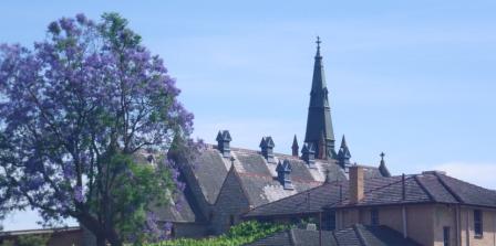
The town of Wangaratta was declared a city in 1959, and amongst the city’s many assets are some well kept historic buildings (for example the Anglican Cathedral, dating back to 1860; St Patricks Roman Catholic Church which dates from 1863 - see the Heritage Trail for more details); the close proximity of many of the North-east’s premier tourist attractions, and a wide range of excellent accommodation.
Because of these factors Wangaratta is one of the more popular bases for touring in the North-east, with annual events including a well organised jazz festival (late October/early November - see the link below).
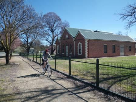
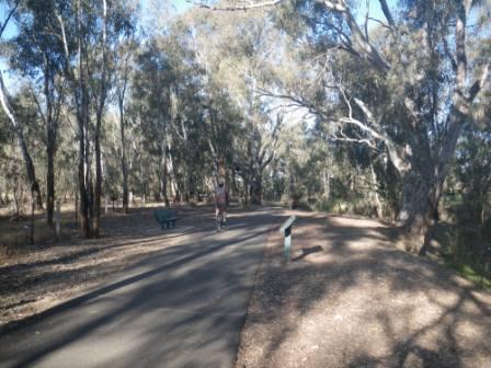
The city is a popular bike riding hub, with Bike Paths, Rail Trails and other cycling routes being close at hand; these include,
Milawa Bike Path
Murray to the Mountains Rail Trail
One Mile Creek Bike Path
See also Bike Paths, Rail Trails & Cycle Routes on the HomePage.
In alphabetic order, things to see and do in Wangaratta include . . .
Art Gallery
The Art Gallery is situated in the former Presbyterian Church (1898) in Ovens St. It has several interesting displays of photographs, social history, architecture, fine arts, applied arts, jewellery and design with a focus on contemporary issues. See the Visitor Information Centre website (link below) for more details.
King George Gardens
King George Gardens face on to much of the Co-op Store frontage and occupy the site of a former riverside market. The market was subsequently moved to Tone Road, south of the CBD (the old Hume Highway), and the present day public gardens (named after King George V) were developed in the late 1920s.
The gardens were opened by Mr (later Sir) John McEwen, then a federal Minister in the Lyons Government (Sir John attended school in Wangaratta, and later became Prime Minister, after the disappearance of Harold Holt; see the Chiltern description for more details).
Heritage Trail
The trail starts and finishes at the corner of Ford and Murphy Street, and takes about one hour to complete. The first item of interest is at the corner of Murphy Street and Ford Street, and is St Patrick’s Church, designed by William Wardwell, (the architect of St Patrick’s Cathedral in Melbourne, and St Mary’s in Sydney).
Construction started in 1865, and the material used was a pale granite (from quarries in the Beechworth area) as well as a freestone from several Glenrowan quarries. Both of these local building materials have endured the passage of time and show up well, particularly at night when the building is floodlit.
Close by St Patrick’s (in Ford Street), the Wangaratta Historical Society Museum (formerly a fire station) dates from 1895, when the Country Fire Brigade was formed. The VIC has a brochure on the Museum, and this details the opening times; more information from the Historical Society website (link below).
To the left of the main entrance, there is a horse watering trough, one of many hundreds manufactured in Australia by wire maker, cum-manufacturer, William Bills during the mid-late 1800s. To the right there is a memorial plaque detailing the civic endeavours of noted Wangaratta citizen, William Henry (Billy) Edwards (1864-1949), a blacksmith by profession (the building is also named after Billy; see the upper facade).
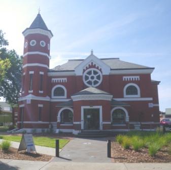
Continuing down Ford Street to the corner of Ovens Street, turn left to find the Exhibitions Gallery. This was established in 1987, and occupies the site of the former Presbyterian Church which was erected in 1864, and completely rebuilt (as the present building) in 1898-99.
Additions and renovations during 1929 and 1957 saw the building take on its present appearance, and in 1985 the building was sold to the City. However the original stained glass windows, the church bell and the pipe organ were removed prior to sale, and were subsequently re-installed at the Emmanuel Uniting Church in Rowan Street, Wangaratta (see below).
Further down Ovens Street, at the corner of Cusack Street, the Bishops Lodge is a Victorian era (1904) two-storey structure that has many of the hallmarks of this period, with wrap-around, iron-lace festooned verandahs and impressive gardens.
Turning around, and heading back up Ovens Street, Holy Trinity Cathedral is the next item of interest. This is one of the enduring landmarks of Wangaratta, a Cathedral has been on this site since 1856, and the present structure dates from 1909, having made use of granite from the nearby Warby Ranges.
The nave of the Cathedral was completed in 1965, and the bell tower was added in the mid-1970s. Like nearby St Patrick’s Church, the Cathedral is floodlit at night.
The Monument Gardens alongside the forecourt of the Cathedral were designed by local residents James McLeod and Arthur Rundle in 1924, and originally incorporated memorial obelisks to those who served, and lost their lives, in armed conflict in the Boer and First World Wars. Showing the continued folly of mankind, later additions included the Second World War, Malaysia, Borneo and Vietnam.
A separate obelisk commemorates the service of William Pecky and Edwin Bawden (Bawden came from Eldorado, and has another memorial dedicated to him in his home town; see the Eldorado description for more details).
Opposite the Cathedral, the Wangaratta Community Church (1904) has a Gothic look, as well as Norman archways.
Continuing along Ovens Street towards the city centre, the transformed Co-operative Store building is on the corner of Ovens and Reid Street. This was once one of Australia’s oldest retail co-operatives, and was housed in a much modified building (originally built in 1906), occupying much of the Ovens-Reid-Faithfull-Murphy Street block of the CBD. The Store’s fortunes have waxed and waned over the years, and the building now houses a multi-retail complex, as well as the Wangaratta Cinema Centre and Switch Cafe.
Almost opposite the Co-op Store, albeit slightly hidden by the King George V Memorial Gardens, Emmanuel Church (1885) is home to an estimated 25 000 locally fired bricks. The original church was extended in the 1970s, and is now used by the Uniting Church.
Sydney Hotel, at the corner of Ovens and Templeton Streets, occupies the site of William Clark’s ’Hope Inn’, Wangaratta’s first hotel, originally built in 1840; the name is significant as most of the early settlers in Wangaratta were from Sydney, rather than Melbourne. The present structure has an art-deco theme, and is a popular dining venue.
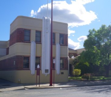
Heading down Faithfull Street (named after one of the early settlers in Wangaratta) the art-deco Court House is on the right, and was built in 1938. It is still used as a court house, and is one of the city’s most photographed buildings.
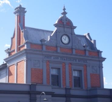
Turning around the corner into Murphy Street, the Post and Telegraph Office (PTO) is on the right; originally opened in 1874, but with modernisation since that time.
The Post Office has since moved closer to the main commercial centre of the city, and the building is now home to a popular coffee shop, and other retail outlets.
A plaque on the front of the PTO remembers three postal workers who died during fire fighting operations in 1943. A more obvious memorial to these brave people can be found on the Great Alpine Road - see the Great Alpine Road description for more details.
Just to the left of the PTO, Commerce House (99 Murphy Street) is a good example of commercial architecture from the art-deco period, and to the left of this interesting building, Glasgow House is typical of the commercial building style of the early 1900s. Slightly further down Murphy Street, Cafe Martini occupies part of the Bulls Head Hotel building (1866; the logo is still visible on the upper facade).
Almost opposite the PTO, the Visitor Information Centre (VIC) is housed in the former library building (1908). The library subsequently moved to Ely Street, and then (more recently) it moved in with the TAFE Library in Docker Street.
To the right of the VIC, the Grand Central Hotel opened for business in 1910, as did the adjoining Corrys Building, a two-storey building with an ornate upper facade.
Closer to the city centre, the stylish Irvings Chambers can be found at the north-east corner of Reid and Murphy Streets; a structure that was probably erected in the late 1840s, making it one of the first substantial buildings in Murphy Street. With its unusual tower (added in the early 1860s) it has been host to many different retail stores, and is currently the home of Reality Boutique and The Music Man.
Turning left into Reid Street, the Pinsent Hotel began life as a private hospital in the early 1850s, and was one of the first brick buildings in the new township of Wangaratta. It was later acquired by John Crisp who converted it to a hotel (the Wangaratta Hotel), and in the early 1920s, Annie Pinsent became the licensee, giving the Hotel its current name.
Almost directly opposite the Hotel, the Strand Arcade has an art-deco style facade, and was originally a cinema.

A quick skip over to the other side of Reid Street, and walking along the north side of the street (so that you can see the facades of the buildings on the south side) reveals the Exchange Building (1878). This well kept building typifies the ’rural produce merchant’ style of architecture that can be found in almost every Australian country town.
Just over a laneway, the former London Chartered Bank (at 49 Reid Street) was built in 1873, and is now occupied by an estate agent.
Making a u-turn, and crossing over to the south side of Reid Street (so that you can see the facades of the buildings on the north side), there is an unmarked facade from the Victorian era above a triple shop frontage, and to the right of this (on the north-west corner of Reid and Murphy Streets), another elaborate, and ornate, structure has its origin in about 1860.
The first building on this site was burnt down in 1860, having been built in 1854 by James Meldrum. The new building was built by the Potter Family, and in 1902 was purchased by Joseph Trotman (a local dignitary), and Joseph added the ornate second story.
The Osmotherly Brothers (Tom and Allan) bought the building in1956, and for many years this corner of Reid and Murphy Street was known as Osmotherly’s Corner. It has also been known as Potter’s Corner, London House and Trotman’s Building.
So, standing at Osmotherly’s Corner it is worth pondering that once upon a time, there were many more heritage quality buildings in the Wangaratta CBD, but by now you will have seen the best of what is left standing. All that remains now is to have a well earned break at one of Wangaratta’s excellent cafes.
See also the Wangaratta Cemetery Tour (PDF download; see link below).
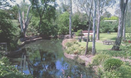
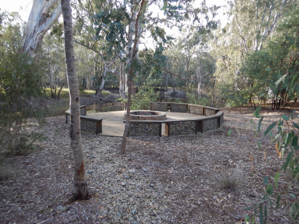
Merriwa and Kaluna Parks
Merriwa Park is a very attractive sunken garden (Victoria’s largest such garden) with a mix of native woodlands, and exotic flower gardens, which occupies much of the original King - Ovens River confluence; a great place to loiter on a hot day, and an interesting place to walk around.
The area that the Park now occupies lies at the base of a river terrace, a geographical feature carved out by the King River over thousands of years of erosional activity.
River terraces form part of a system of paired formations (one on each side of the flood plain) and are commonly known as swing terraces, since (over a long period of time) the river will swing from one side of the floodplain to the other.
Wangaratta CBD is largely built on top of a swing terrace, and as you leave the CBD area to drive (or walk) down into Merriwa Park, the height of the terrace forms an impressive feature, with a six metre height differential from street to the lowest point in the Park.
The fact that the King River swept in so close to the city centre (and in such a broad arc) created problems in the modern era, in that there was insufficient ability to cope with the floodwaters of the King River. The King is a major tributary of the Ovens River, and rises north of Mount Buller, with a very rugged (and large) catchment area that is capable of producing prodigious amounts of floodwater.
Flooding became a recurrent problem after European settlement, and after many years of flood emergencies it was decided to divert the King River away from its close proximity to the CBD, and to create an ornamental garden in the forcibly abandoned floodplain. Prior to this Merriwa Park was renowned as ’the place’ to go swimming and bathing in Wangaratta, with much of the recreation infrastructure of the town being at what is now Merriwa Park.
Flood levees were built to keep the King away from the CBD, and to artificially straighten out the river course, so as to improve its ability to cope with flood peaks. The resultant flat ground created by this engineering is what we now know as Merriwa Park, with the original course of the King River being still visible as a series of billabongs around the western and northern periphery of the Park.
Other interesting features of the Park include lots of tall timber, ornamental gardens, widespread usage of the former floodplain’s flat ground for tennis courts, and a good scattering of day visitor amenities.
The major feature of the eastern side of the Park is the flood levee, which mostly (but not always) succeeds in keeping water away from Merriwa Park.
On the opposite side of the levee, it is easy to walk down into Kaluna Park, another piece of the floodplain, but this time in a much more natural setting.
Kaluna Park has a series of signposted walking tracks, most of which make contact with the King River, thereby providing a nice opportunity to imagine what the original floodplain, and its riverine vegetation, looked like. An information board (just over the levee bank) from Merriwa Park has a map, and gives details of the walking track network.
As Kaluna is on the south side of the levee banks, it does get inundated whenever the King River gets to a moderate flood level. This means that it may not always be possible to tackle the walking tracks, and that they may be wet underfoot. The VIC (in Murphy Street) has a brochure on the Park, with a sketch map of the walking tracks.
Milawa Bike Path
There is now a dedicated cycling route from Wangaratta to Oxley, and on to Milawa, with a gravel pathway under your wheels all the way. The route starts in the south-west corner of the Wangaratta urban area, and basically follows the tracks of the now defunct Wangaratta - Whitfield Railway to Oxley, and then swings north on its way to Milawa.
See the link below for further details on this popular cycling route.
Murray to Mountains Rail Trail
The Murray to the Mountains Rail Trail currently runs from Wangaratta to Bright, following the 83km path of the former railway that ran between the two towns. The Rail Trail was progressively developed starting from the early 1990s, and the present infrastructure was completed in 2002; it is now used by about 50 000 cyclist a year.
See the link below for further details on this excellent Rail Trail.
Mullinmur Billabongs
The Mullinmur wetland area stretches over about 20 hectares of the Ovens River floodplain, and is located on the northern side of the urban area.
Vehicle access to this interesting part of town is via the Yarrawonga Road, and then the corner of Phillipson Street and Cambridge Drive, where there is a limited amount of car parking space.
The vegetation of the wetland consists of River Red Gums, Silver Wattles and Honey Myrtle; wildlife includes Barking Owls, Regent Honeyeaters, Egrets, Sugar Gliders and Possums.
There are a few variations on the walking tracks here, and these provide about two kilometres of walking options, all very enjoyable.
There are several opportunities to sit and admire the surroundings during the walk, making this a popular venue.
Museum
The Wangaratta Historical Society Museum can be found in Ford Street, and as mentioned in the Heritage Trail text above, the building was formerly a fire station, and dates from 1895, when the Country Fire Brigade was formed.
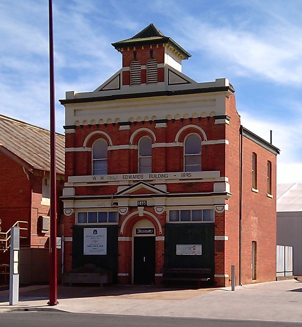
The fire bell on top of an adjoining tower has long gone, and to the left of the main entrance, there is a horse watering trough, one of many hundreds manufactured in Australia by wire maker, cum-manufacturer, William Bills during the mid-late 1800s.
To the right there is a memorial plaque detailing the civic endeavours of noted Wangaratta citizen William Henry Edwards (1864-1949), a blacksmith by profession.
The Museum houses many items of memorabilia, and artefacts, from Wangaratta’s interesting past, and is a great place to browse around.
The VIC has a brochure on the Museum, and this details the opening times etc. Even more information on the Museum can be found the link shown below.
One Mile Creek Pathway
This route basically follows One Mile Creek, a waterway that has its catchment area to the south-west of the city.
From end-to-end, the adventure starts at Cribbes Road (on the south-west side) and finishes at the Yarrawonga Road (on the northern side of the city).
In between these two end points there are many different combinations, with the end-to-end journey being about 5.3km.
See the link below for further details on this scenic urban walk.
Performing Arts Centre
Wangaratta’s Performing Arts Centre (WPAC, or PAC for short) can be found on the corner of Ford and Ovens Street and is the city’s main focus point for the performing arts. Prior to 2008, the Memorial Town Hall stood on this site, and this served as the municipal offices from 1867 to 1962. After 1962 it became the venue for events such as amateur theatre, dances and black-tie dinners during the Jazz Festival.
When the proposal to demolish the Memorial Hall, and replace it with the PAC, was first mooted there was considerable opposition to the idea, but the project went ahead and the city subsequently gained a first class performing arts venue.
The PAC has a varied program throughout the year, and the calendar of forth-coming events can be found via the link shown below. The Centre is well patronised, particularly during the Jazz Festival, and is a huge asset to the city.
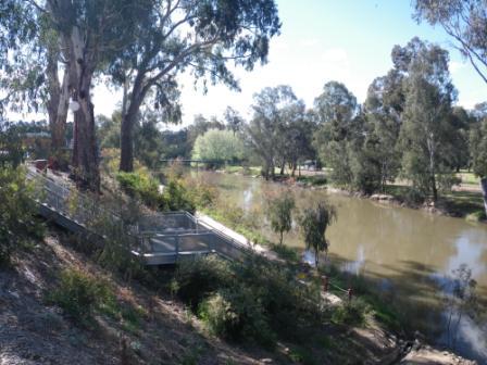
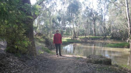
Riverside Walk [AWTGS-2]
The Ovens River rises north of Mount Hotham and from its headwaters flows past Bright, Myrtleford and Wangaratta before joining the Murray River in the backwaters of Lake Mulwala. In this section of the it’s journey to meet up with the Murray, the Ovens can still be quite fast flowing, however it does have its quiet sections, and these are where the city’s most popular swimming spots can be found.
Alongside the water, Wangaratta’s riverside walk provides a popular exercise routine for the city’s inhabitants (walkers, dog-walkers and cyclists), and will soon be extended (upstream to the Bickerton Street suspension bridge) to provide a few more kilometres of enjoyment.
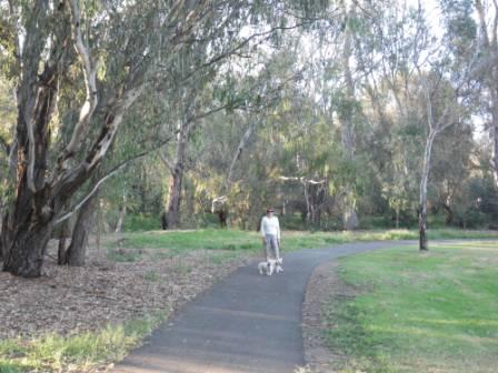
For the present, access to this nice piece of urban infrastructure is by parking (or walking) to the corner of Templeton Street and Baker Streets, and following the wide driveway that leads down to some riverside parklands. Alternative access is from the corner of Evans Street and Grey Street; this is on the northern side of the city centre, just off the Yarrawonga Road.
From either starting point, the walking track closely follows the left bank of the Ovens River downstream to College Street (an alternative access point, where there is also a reasonable amount of car parking space). There are several minor detours along the way, all of which lead to riverside picnic areas, most of which are easily accessible given normal river flows (some get submerged in high water). In any case, scenery is excellent, with continuing views of the scenic Ovens River, its riverine vegetation and birdlife.
HUME FREEWAY - ACCESS
Wangaratta was for many years host to the Hume Highway, but with the opening of the Freeway, ended up on a bypass, making the centre of town a much nicer place. From south of the city, access involves taking the first sign-posted Wangaratta exit; this leads on to the old Hume Highway, which in turn (as Tone Road) leads easily to the CBD (the old Highway is called Murphy Street in the CBD, Parfitt Road once you get north of the Ovens River).
An alternative route into Wangaratta involves staying on the Freeway for a few more kilometres, and then taking the Greta Road exit. Veering left from the exit, this leads into Greta Road, which joins up with the old Hume Highway about a kilometre south of the CBD. The Greta Road exit is part of a full clover-leaf junction, so this is also an option for southbound traffic.
East of the city, there is a third Freeway interchange; this one providing access to the Great Alpine Road as well as Wangaratta. When heading north, Wangaratta is to the left, the Great Alpine Road to the right, and vice versa when heading south.
Just to the north of town (about 10km), the final interchange junction is sign-posted Wangaratta, and involves a looping left turn for north bound traffic. This then leads into a section of the Old Hume Highway (Parfitt Road), and takes you into the city centre via the Thomas Mitchell Bridge over the Ovens River.
From the north, this same intersection also involves a looping turn to the left, and then right - again arriving at a section of the old Hume Highway, not far north of the city.
GREAT ALPINE ROAD (Wangaratta, Bright, Mount Hotham, Omeo, Bairnsdale)
MURRAY to MOUNTAINS RAIL TRAIL
Wangaratta Cemetery Tour PDF download
Wangaratta Performing Arts Centre (PAC)
Wangaratta Visitor Information Centre
Intro Screen on a fresh browser page
COPYRIGHT © 1995-2024, Chris McLaughlin.