ELDORADO
(www.northeastvictoria.online)
The historic little enclave of Eldorado, once famous for it gold and tin mining (from the 1850s to the 1950s), is a very popular destination, and is perhaps best-known for its alluvial gold dredge.
In its heyday, the town had a series of ‘suburbs’, with Napoleon Flat, Sebastopol Flat and Woolshed Valley being the main outlying areas, giving an overall population in the district of about 7000.
The historic village of Eldorado grew up around the pastoral property Eldorado founded by a retired captain of the Royal Navy. Captain William Baker arrived in Sydney in 1837, and in 1840 (along with many others) moved south to the Ovens District, taking up the pastoral run which he christened Eldorado.
It is not known why the name Eldorado was chosen, but it was certainly appropriate, given that gold was subsequently discovered in the area in 1852. This lead to a Gold Rush all over the North-east, and whilst Eldorado was once famous for its gold mine, it is now popular with visitors from all over Australia, and is perhaps best-known for its gold dredge (details below).
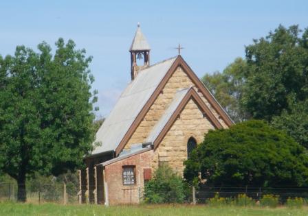
Eldorado is also a town of churches; St Judes Anglican Church was built in 1870, and is classified by the National Trust; St Augustines Catholic Church was also built in 1870, and is made of handmade bricks; and finally the Uniting Church, which was built in 1914, replacing the previous building which was constructed in 1870.
Two of the original buildings in the town remaining intact are the bakery and the police station, both of which are now private homes.
Other items of interest in and around town include the Eldorado Museum, situated in a former schoolhouse, which is home to many reminders of the past, particularly in relation to the region’s mining history. More details on the museum can be found via the link shown below.
The Museum also has a small brochure which describes a number of historic sites around the township.
Accommodation wise, there are a number of holiday houses for rent in, and around, the township (Wangaratta VIC has the details; see the link below); please note that the Gemstone Caravan Park has now closed.
Food wise, McEvoy Tavern serves meals most days of the week, but check their website (link below) for opening times.
For picnickers, Gunhouse Park (in the centre of town) has tables and chairs with plenty of shade, and an adjoining toilet. A series of story boards near Gunhouse Park provides quite a detailed history of the town, and its environs, and these make interesting reading.
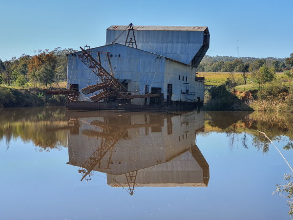
Cocks Dredge
Cocks Dredge was one of many that were used world-wide to process gold from the vast deposits of alluvial soil that are scattered around the globe. Amazing wealth was generated by such operations, but in many places the environmental costs were high. Dredges had previously been used in the river valleys of places like Colorado and New Zealand, and were introduced to Victoria at the end of the nineteenth century; Cocks Dredge is one of few intact machines found anywhere.
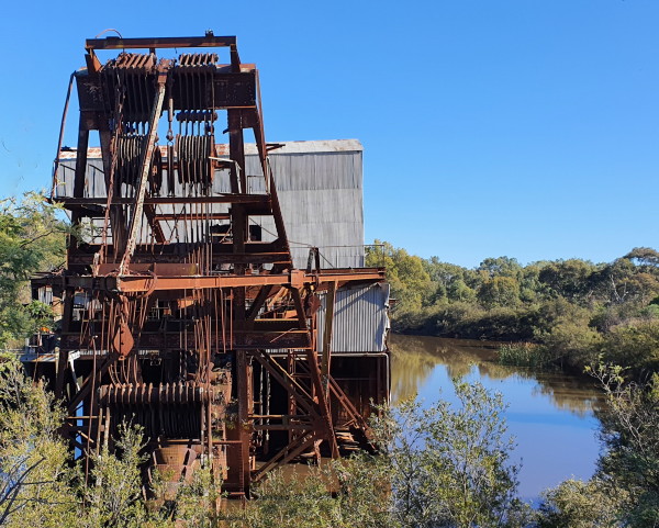
Weighing 2,500 tons, Cocks Dredge now rests (floating) in a pondage it helped create; the Dredge stopped working in 1954, and up until then had obtained about 80,000 ounces of alluvial gold and 1,450 tons of tin.
The signposted turn-off to the Dredge is a few hundred metres before the town boundary, and having located the signposted access road, you then need to turn into the car park.
Apart from admiring the Dredge from the carpark, you can also take the gang-plank and have a look at this monster's innards. There is also a walking track that circles around the pondage that the Dredge is floating on; this is a nice 15min leg-stretch.
There is also a walking track (AWTGS-2) from the centre of Eldorado that is a popular way to get to the Dredge.
The overall distance from the town centre is about five kilometres (this assumes that you will take the loop track around the Dredge). Allow about two hours for this outing, as this will give plenty of time to check out the innards of the Dredge.
Parks Victoria has a handy PDF that details all you need to know about the Dredge (and dredging) and this file can be found on their website (see below).
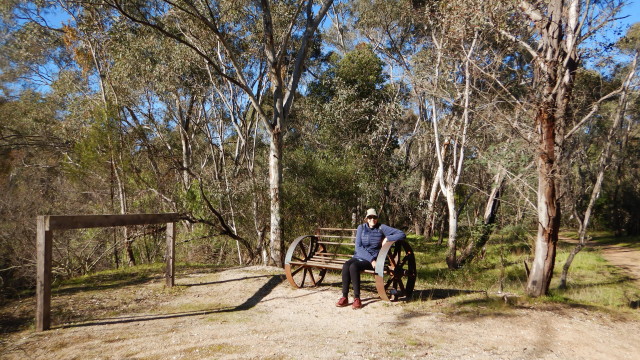
Reids Walk [AWTGS-2]
Reids Walk is a short stroll through a former alluvial gold mining area, and when all of the information boards are in place, will provide an outline of alluvial mining history in this area.
You can access the walking track by taking McEvoy Street (from near the centre of town), and then parking alongside the signposted walk start. This leads down towards Reedy Creek, and then follows this waterway upstream to a suspension bridge over the Creek.
In either case, on the way, there is widespread evidence of the impact of alluvial gold mining on the local environment, as well as some opportunities to get down to the Creek and take a dip.
The walk more or less finishes at the pedestrian suspension bridge, just short of the Woolshed Valley Road. Having inspected the bridge (there is a new bridge here, right alongside the old one), it’s time to make a u-turn, and head back to the township.
Walking distance is about 1.1km each way, and the time taken overall is about 45 minutes.
An alternative option is to start walking from the centre of the village (where there is a handy map) and return to the village via Firebox Bakery, giving an overall pedestrian distance of about 3.6km, and a walking time of about one hour.
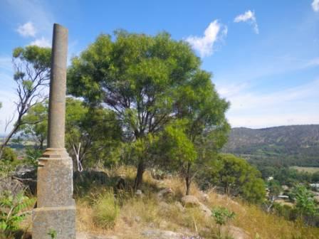
Monument Hill [AWTGS-3]
This rugged outcrop of granite guards the north-west corner of Eldorado, and is home to a monument to Farrier Edwin Bawden who died whilst serving with the Imperial Bushmen during the Boer War of 1900-1901. The original memorial plaque is on the northern face of the Monument, whilst a new brass plaque (supplied by the RSL in 2004) adorns the western face. The upper section of the actual Monument is missing, a salute to a life cut short.
There is a notional walking track route up to the Monument, but (at present) it is fairly difficult to find. In the meantime there are two different access routes to choose from, and (as with most things in life) there is an easy-ish option and a hard option.
Easy-ish. Drive out of town by taking the Woolshed Valley Road for about 800m (measured from the centre of town) and turn right onto a grassy laneway, directly opposite Colin Angus Drive. Follow this laneway upslope to a vehicle turn-around area, passing a Parks Victoria sign on the way.
Having parked your vehicle, Monument Hill is the high ground immediately on the township side of the laneway, and from the laneway, you need to scale the rocky slopes to get to the summit. Allow about 10 minutes to get to the summit, and about eight minutes to get down again. There is no formal pathway, so you need to keep the summit in sight, and be prepared for some rocky terrain as you gain altitude.
Do not wear shorts for this outing, and have some good footwear, and a good pair of gaiters, to keep out some of the more aggressive seed pods out of your socks.
Hard. Park your vehicle near GunHouse Park, and walk up the Tarrawingee Road for about 100m, to where Percy Street heads off to the left. Follow Percy Street for about 50m to an unsignposted grassy laneway heading off to the left. This leads to a small forlorn looking water tank on a pedestal, and this is where the action begins.
The Monument is visible at this point (high on the hill to the right of the laneway) and from here you need to head onwards, and upwards, to get to the summit.
As mentioned, there is no formal pathway, so you need to keep the Monument in sight most of the time, and be prepared for some rocky terrain as you gain altitude. Allow about 15 minutes to get to the summit, and about 10 minutes to get down again.
As well as the steep terrain, there are some fearful weeds en route, and it is wise to not wear shorts for this outing, and to have some good footwear, and a good pair of gaiters, to keep out some of the more aggressive seed pods out of your socks.
There are plans to cut a formal walking track through to the Monument, and the route of this is shown on some maps of the township. Once cut, this should provide a much easier route than those described here.
See also the Beechworth via Eldorado and Woolshed Valley tour, and the description of Chiltern - Mount Pilot National Park, for additional items of interest in the area.
BEECHWORTH via Eldorado and Woolshed Valley
CHILTERN - MOUNT PILOT NATIONAL PARK
Wangaratta Visitor Information Centre
Intro Screen on a fresh browser page
COPYRIGHT © 1995-2024, Chris McLaughlin.