TALLANGATTA
(www.northeastvictoria.online)
The present township of Tallangatta is quite new, as the old one was drowned when the wall of Lake Hume was raised in the 1950s. The original township developed in the 1850s, pushed along by nearby mining, timber and pastoral interests, but was to survive for a mere 100 years.
In 1918, the River Murray Commission unveiled plans for a new super-dam at the confluence of the Mitta Mitta and Murray Rivers, and part of this initial design included the news that the existing town of Tallangatta (also shown as Toorak on some maps) would need to be relocated. However, Stage 1 of the project (completed in 1936) left Tallangatta untouched, but it was expected that inundation would be an option at sometime in the future.
Finally, in the early 1950s, the dam wall of Lake Hume was raised, and time was up for the old township. A site near the railway siding of Bolga (on the now dismantled Wodonga - Cudgewa Rail) was selected as a suitable place for the new town, and the big move began, with the new township being officially opened in 1956.
The Tallangatta and District Museum (at 75 Towong Street) has heaps of well collated information on the big move, as well as many other aspects of local interest for history buffs.
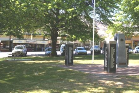
Present day Tallangatta is slightly off the Murray Valley Highway, and makes an excellent base camp for touring the surrounding area. In peak holiday periods this is a busy place, as it provides many opportunities for boating and fishing, as well as touring.
The town celebrates the anniversary of its new life by holding a Fifties Festival in October of each year; see below.
Accommodation options include the Lakeland Caravan Park (on the shores of Lake Hume), with the town also having several motels, as well as some holiday cottages and B&Bs.
Food wise, there are two hotels (the Tallangatta Hotel and the Victoria Hotel), several very good cafes, and a good array of take-away options. Contact the Corryong VIC for further information on accommodation and eateries. Rooftop Maps, Upper Murray Adventure Map has all the details for successful exploration of the Tallangatta area.
There are plenty of things to see and do around Tallangatta, and things of interest close to town include . . .
High Country Rail Trail
This scenic rail trail follows the path taken by the former Wodonga - Cudgewa Railway, and leads from the eastern side of Wodonga through to the site of old Tallangatta, with a gap in the pathway at the former Sandy Creek Railway Bridge.
Access from Tallangatta township is by cycling up to either of the Murray Valley Highway entrances to the town, with Wodonga being to the right, and Old Tallangatta being to the left. More details on this great ride from Bike Paths, Rail Trails and Cycle Routes on the Homepage.
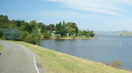
Lakeside Walking Track
The Lakeside Walking Track can be reached by taking Queen Elizabeth Drive from the centre of town, and following this to the waterfrontage. The Lakeside Walking Track then heads off to the east (upstream) following the shoreline of Lake Hume quite closely, before swinging off to the right so as to make a loop around the township, with some great views of the Lake, and surrounding hill country, on the way.
Old Tallangatta
As mentioned above, the original township of Tallangatta is now underwater, however the old townsite can still be viewed from a roadside lookout, about five kilometres to the east of the new town. The High Country Rail Trail passes by the lookout, so this makes a nice short ride from town.
However, there is plenty of car parking space here (including a long pull-in for caravans) so Highway travellers can get a peep at the views.
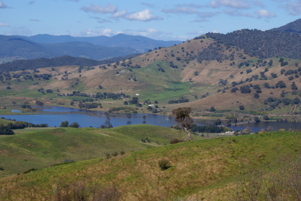
The Lake needs to be super-low before any of the human infrastructure of the old town becomes visible, however it is interesting to imagine how the settlement would have looked in the pre-dam days.
Tallangatta Lookout
Tallangatta Lookout is a short drive (about 500m) to the west of town, and provides excellent views of Lake Hume’s waters stretching away into the distance; it is only when you get to vantage points like this that the enormity of the Lake really strikes home.
The Lookout is clearly signposted on the Murray Valley Highway, and involves a short detour from the main road. There is plenty of room for turning around at the car park, but it is best to not take a caravan up this access road.
Intro Screen on a fresh browser page
COPYRIGHT © 1995-2020, Chris McLaughlin.