HARRIETVILLE
(www.northeastvictoria.online)
Harrietville is one of Victoria’s many sub-alpine villages, this gem, with its beautiful tree-lined streets, being situated at the confluence of the East and West Branches of the Ovens River.
Like many towns in the North-east, Harrietville came to life as a gold mining settlement during the early 1850s, and was also a transit point for supplies to the Dargo, Omeo and Crooked River Goldfields.
The township has provided tourism related services since the 1930s, and is still is a popular ’off-mountain’ dormitory for the Mount Hotham ski-resort; it is busy and energetic in the ski season, and still very enjoyable once the snow melt starts.
Accommodation options include motels, a hotel, cabins and a riverside caravan park, making this a good stop-over point before tackling the ’high road’; see the links below, and the ‘Where to Stay’ listing available via the homepage.
The town also has a general store, a fuel outlet and some popular cafes.
Coming in from Bright, Tavare Park is to the left, just before the Ovens River (East Branch) Bridge, and is one of several convenient places to take a break.
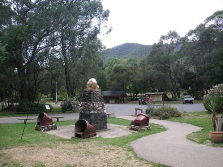
Pioneer Park is also to the left, just after the Bridge, and items of interest here include, life-like statues of two gold miners, other gold era memorabillia, a memorial to the work of Ferdinand von Mueller, picnic facilities, plenty of shade, toilets, and easy access to the rest of the township.
The Recreation Reserve is to the right, just before the alpine gradients start to appear, and this is also a popular rest area.
There are several short walks, in and around, town that provide a nice glimpse into the town’s history, and beautiful surroundings.
Bungalow Spur Track - Tobias Gap
Notes on walks in the area can be found in a brochure entitled Harrietville Tracks and Trails, available at the Bright Visitor Information Centre, and at several locations in Harrietville.
Bon Accord Track
The first part of the Bon Accord Walking Track (which ultimately leads up to Mount Feathertop and Mount Hotham) can also be enjoyed on a casual basis (that is, without tackling the steep sections that lead to the alpine area).
The track is mostly a narrow, single file footpad, and the terrain requires a good set of walking shoes/boots, as well as a set of trekking poles.
Access to the start of this pleasing walk [AWTGS-3] is by taking Bon Accord Lane (from opposite the entrance roadway that leads to the caravan park) and following this through to the edge of the township.
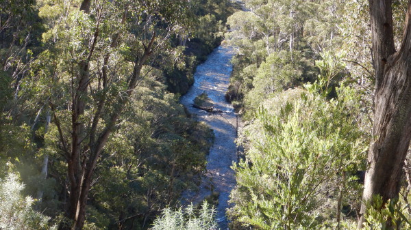
This places you alongside the East Branch Ovens River, the valley of which can be followed upstream for about five kilometres to a bridge over the Ovens at the Washington Creek confluence.
There is good signage at the trail head, but take care to step it out on the correct foot pad.
Once at the confluence, there is plenty of flat ground to have lunch on, and then it is time to make a u-turn.
For the technically minded, the GPS data at the bridge is 36:55:40.9 / 147:04:48.2, and the altitiude is 606m.
The full outing (that is, to the bridge, and back) covers about 11km, but you can turn around at any time so as to shorten the outing. Allow about four hours for the full tour, as described.
There are many excellent views of the Ovens River from the track, as well as great views of the forest, and the high country, and it would be a pity to rush this walk.
During winter there are several great views of the snow capped peak of Mount Feathertop, as well as of the ridgeline of The Razorback. Later in the year, the wattle blooms are exceptional.
An alternative access point is from Pioneer Park (on the left as you drive in from Bright). From here take the riverside track upstream. This will lead you to the trail head as described above, but giving an overall distance of a little over 12km, and a walk time of about 4.5 hours.
Bright To Harrietville
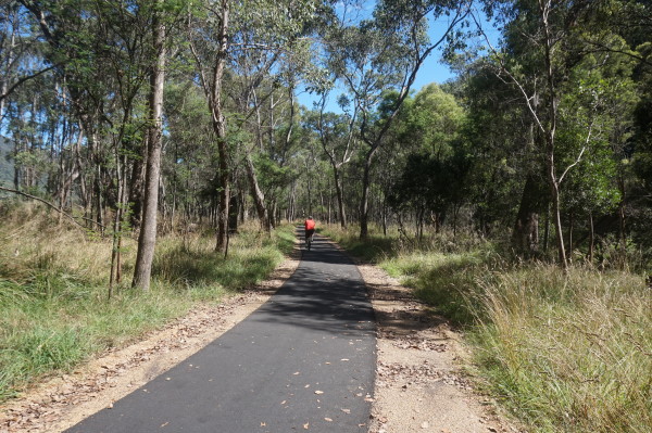
The Bright to Harrietville shared pathway (pedestrian and cycle) basically follows the GAR from Bright to Germantown, and the next section (that includes several new bridges) leads off to Freeburgh, Smoko and Harrietville.
The complete route covers about 24km (each way) and offers a mix of surroundings, with the best scenery to be found between Germantown and Freeburgh, and then from McMahons Road through to about a kilometre beyond the Harrietville Trout Farm.
However, the complete journey is very enjoyable, and it is a popular outing from both ends of the trail.
The Bright Visitor Information Centre (link below) has more info on this great project.

Bungalow Spur Track - Tobias Gap
The first part of the Bungalow Spur Track (which ultimately leads up to Mount Feathertop) can also be enjoyed without going all the way to the alpine area.
This is mostly a narrow, single file footpad, and the terrain requires a good set of walking shoes/boots, a set of trekking poles, a good ration of food, and about 1.5 litres of water per person.
The route taken here is clearly marked on Rooftop Maps Mount Feathertop - Hotham and on Spatial Vision Maps Bogong Alpine Area.
The track has its origins in the early 1900s, when, at the instigation of Robert James (Jim) Tobias and the Harrietville Progress Society, a track was cut, following the ridge system up towards Mount Feathertop.
In 1925, the Feathertop Bungalow (a hotel) was built, and operated successfully until it was destroyed on Black Friday, 1939. Long before that tragic event, the track to the Feathertop Bungalow had become known as Bungalow Spur, a name that endures today.
Tobias was born in Bright (1870) and was PostMaster at Harrietville from 1899 until 1915. He was a very enthusiastic photographer, and Tobias Gap, and Picture Point, are named in his honour.
The action starts at the eastern end of Feathertop Lane, where there is a sign-in book for all walkers.

This is at an altitude if 557m, and from here the foot track heads off on a gentle slope, the start of a 4.6km, 600+m climb to Tobias Gap.
However, the track is well engineered, and is rated as a moderately hard walk [AWTGS-3], but not super-strenuous.
Landmarks on the way include excellent scenery, the sounds of gurgling water from various cascades way down below, and remarkable wattle blooms in late September.
Picture Point (a favourite spot for morning tea, 840m altitude) is encountered after about two kilometres, and from here it is a further 2.6km to Tobias Gap (1138m).
Both Picture Point, and Tobias Gap, are sign-posted, and both have a seat to rest on.
The return route is by retracing your footsteps, with many great views of the valley floor on the way back down to the start.
Travel time (including breaks) will have been about four hours.
Ovens West Track
The Ovens West Track (a continuation of Mill Street) is a vehicular track that leads off to the south of the township, basically following the path of the Ovens River (West Branch) upstream.
It is an enjoyable walk to follow this track through to a ford across the river, and then return to town.
This was a major route for the gold miners, and there are still many relics from this era visible to the right, and left, of the roadway.
Take care to listen out for the occasional vehicle, as this route is used by 4wd travellers to access the range country to the east, and south, of Mount Buffalo.
The complete walk (to the ford, and back) takes about two hours, and is rated AWTGS-3.
Riverside Walk
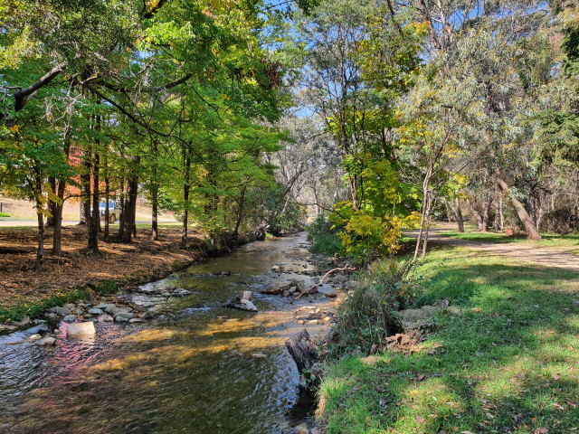
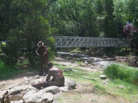
The Riverside Walk [AWTGS-2] starts at Pioneer Park (township side of the Ovens River Bridge), and follows the East Branch upstream for about a kilometre. Turn around at the Bon Accord Track access, and return to the starting point.
Allow about an hour for this 'there-and-back' walk.
A new bridge (built in 2023) at the end of the trail (that is, just before the Bon Accord Spur Track goes off to the right) enables walkers to cross the river, and to join up with the Tronoh Dredge walks (see next description).
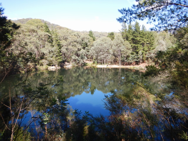
Tronoh Dredge
The Tronoh Dredge Workings (a lake that is a legacy of the alluvial gold mining era; see the introductory section of the book for details on gold mining) is located just to the north of town, and offers a 1.5km loop [AWTGS-2] around the Tronoh Diggings.
Initial access (vehicular) is by taking the Mount Feathertop Road from the Bright side of the Ovens River Bridge (known as School Bridge), and following the signposts to the waterside car parking and picnic area.
There is plenty of shade here, and this is a popular place to spend a few hours. Some people take to the water here for a cooling swim; however this is a venue for experienced swimmers only, and is not suitable for beginners, or small children.
An extension of the above walk is to park at Tavare Park (just over the Ovens River; that is, on the Harrietville side of the Ovens River Bridge) and from there, follow the sign-posted walking track through to the Dredge. This adds about a kilometre to the main walk.
Another variation on this walk is to set out from the caravan park, stepping it out to the GAR.
From here, keep straight ahead, following the bitument of the Bon Accord Track as it curves around to the right.
Once in sight of the Ovens River (800m) hang a left, and follow the levee bank to a footbridge over the River (a further 600m).
Cross over the bridge, and follow the narrow footpad to the Tronoh Dredge car parking/picnic area.
Having completed the loop of the Workings, return to the footbridge, and then turn right, making your way to Tavare Park.
From here, turn left, and follow the GAR back to the caravan park turn-off, and then the caravan park itself.
This will have been a four kilometre loop - one of the many popular walks from the caravan park.
Charley Miley Walking Track
The Charley Miley Walking Track [AWTGS-2] leads off from the sports oval (north side of town) and meanders through a former gold mining area, before returning to the township, and covers about three kilometres (allow about an hour for this loop). The walk is named after Charley Miley, a former world champion axeman, and resident of Harrietville.
Alpine Getaways (accommodation bookings)
Harrietville Historical Society
Bright Visitor Information Centre
BOGONG ALPINE WAY(Bright - Mount Beauty - Falls Creek - Omeo - Mount Hotham - Bright)
GREAT ALPINE ROAD (Wangaratta, Bright, Mount Hotham, Omeo, Bairnsdale)
Intro Screen on a fresh browser page
COPYRIGHT © 1995-2024, Chris McLaughlin.