MYRTLEFORD
(www.northeastvictoria.online)

Myrtleford is located near the confluence of the Buffalo and Ovens River and, like many towns in the North-east, owes its existence as a township to the gold rushes of the latter half of the 19th century.
The township formed around a pastoral property known as the Myrtle Creek Run, but when gold was discovered in the nearby Buckland Valley, thousands of fortune seeking hopefuls had to cross the Ovens River on their way to the goldfields.
Expectedly, a small township developed around the crossing place, and the town was known as Myrtle Creek until 1871, when it was renamed Myrtleford.
Traditional gold mining continued in the area until about 1900, when alluvial (dredge) mining took over, lasting until about 1920.
The Ovens Valley Railway (Wangaratta to Bright) came to town in 1890, and this drove a rapid expansion of the town’s tourism infrastructure, particularly the ability to service the newly constructed Mount Buffalo Chalet.
Tobacco growing was a major agri-business in the Myrtleford area for many years, but modern day Myrtleford is as much about tourism as it is about agriculture.
Amongst the town’s many assets, the Murray to Mountains Rail Trail passes through the town centre, and it is about 30km from here to Bright, and about 50km to Wangaratta. See the link below for more details.
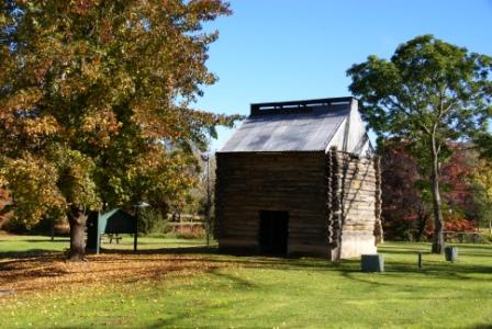
Barwidgee Park (just on the Wangaratta side of the urban area) is home to a good example of the original tobacco drying sheds, and it is worthwhile stopping here to learn something of the techniques used in times long-past.
Accommodation options include motels, a hotel, cabins and two caravan parks; the town also has a wide range of shops, services, cafes (pizza being a speciality - see below) and tourist infrastructure.
Myrtleford is also home to a rich Italian heritage, with the annual La Fiera Festival showcasing much of this heritage. The Festival is held in mid-May each year, and is a celebration of Italian culture, with music, food, wine, entertainment and art providing a very enjoyable occasion. See the link below for more details.
Reform Hill [AWTGS-3]
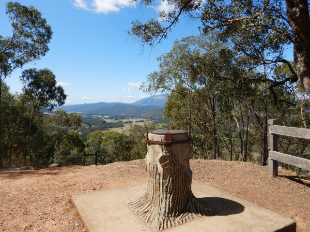
Reform Hill was the site of a significant gold mining enterprise in the Myrtleford area, and was a major employer at the time. In present times, Reform Hill is renowned as an enjoyable place to go and admire some great views of Myrtleford, and its environs.
The walking track loop described here takes about two hours to complete, and burns a fair amount of blubber in its 3.45km.
There are many storyboards on the way, and these cover a variety of information, all of them worthy of a quick stop.
All of the tracks described deserve some care as there is loose terrain, as well as several gold mining relics in the area; small children and dogs should be kept under restraint.
A good set of walking shoes/boots are recommended, as are a set of trekking poles.
If you prefer, it is possible to drive almost all the way to the top of the peak (via the separate access road), leaving only a short stroll to get to the main lookout.
The Great Alpine Road (GAR) passes through the main business area of Myrtleford (Myrtle Street) and you can access the start of the walk to Reform Hill by parking near the information board/gold stamper, just off the GAR (left when heading out of town towards Porepunkah, right when coming in from Porepunkah).
Heading off, up-slope from here, it is about 150m to a t-junction where you need to turn left. The walking track now meanders around the hillside for about 400m, to a t-junction where there is a minor footpad that leads downslope to the Hume and Hovell Memorial (erected in 1924 to commemorate the centenary of their discoveries).
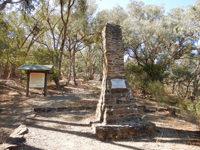
After having viewed the Memorial, retrace your steps to the previous junction, and continue upslope to a t-junction, where you need to turn left. Prior to this there is an information board to read, regarding the construction, and operation of the Reform Hill Ventilation Shaft.
The route now leads to the former Myrtleford Reservoir, and the walking track follows the perimeter of this structure. The reservoir operated from the late 1800s to the mid 1920s when it was deemed inadequate for the growing township.
Continuing on, it is a short distance to a signpost that indicates the Reform Hill Lookout to the right, and the Poverty Reef Mine to the left. Our route keeps to the right at this point, and a small snig track off to the left is soon encountered.
This leads to the vehicular access track for the car parking area, and can be ignored.
Continuing around the hillslope, there are many grass trees to admire, before reaching another signposted intersection after about 250m from the snig track.
Turn left here for the Reform Hill Lookout, now a mere 150m away.
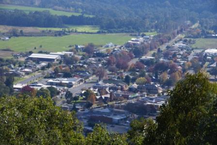
Once at the Lookout, there is a picnic table with great views of the township, as well as Mount Buffalo.
The views of the township are particularly rewarding during autumn, when all of the streets are picked out by a blaze of colour.
Return to the previous intersection, and make your way downhill (that is, follow Spur Track) towards another t-junction (750m away).
Here, you need to turn left, for a short stretch of track (about 300m) to another t-junction.
Turn right here, and it is a gentle descent to the initial t-junction near the start of the walk. Turn left here, and your vehicle will be in sight.
It must now almost be time to reward yourself at one of Myrtleford’s excellent cafes.
Riverside Loop [AWTGS-2]
This is a loop walk of about five kilometres that follows a section of the Murray to Mountains Rail Trail, and then the Ovens River (or vice versa).
The walk starts out from the small parkland in Clyde Street, alongside the War Memorial, and the memorial to Albert Lowerson VC.
From here, head west (that is past the shops, with the Post Office on your left) to meet up with Smith Street.
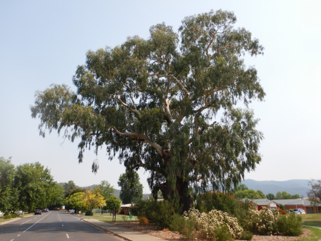
This leads past the Big Tree (an ancient river red gum) with its informative story board.
At the end of Smith Street, you need to make a left turn onto Princes Street, and then carefully swing right, taking the footpath/service road that leads west (that is, towards Gapsted) out of town.
This takes you past the Phoenix Tree, a timber sculpture created from the trunk and roots of a river red gum.
The sculptor was Hans Knorr (1915-1988), a local artisan who was an internee at the Whorouly POW camp; the carving was unveiled in 1986.
Continuing on, the historic tobacco kilns come into view on the left, and you can either cross the GAR at this point (take care) or continue on for about 100m to where there is a pedestrian tunnel under the GAR.
Once at the small parkland, there are toilets, plenty of shaded picnic areas, as well as the tobacco kiln.
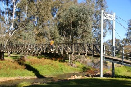
Taking the bridge (which leads over Happy Valley Creek) follow the walking track for about two kilometres to the next road access.
This is the best section of the trail, with two river crossings (over the Ovens River, at bridges) as well as some very enjoyable riverine scenery.
The end of this section of the trail is marked by a small carpark, as well as a nicely muralled toilet block.
Swing left here, and follow the signage as the Trail crosses from one side of the roadway to another, eventually leading back to the roundabout near the Foodworks Supermarket.
Alternatively, swing left into the access lane way that leads to the Bowls Club, and the caravan park, and then curve around to the right to the pedestrian bridge over Happy Valley Creek (this bridge is upstream of the bridge over the Creek already mentioned).
Allow about 90 minutes for the walk, as this will allow plenty of time for loitering at the best views etc.
GREAT ALPINE ROAD (Wangaratta, Bright, Mount Hotham, Omeo, Bairnsdale)
MURRAY TO MOUNTAINS RAIL TRAIL
Myrtleford Visitor Information Centre
Intro Screen on a fresh browser page
COPYRIGHT © 1995-2025, Chris McLaughlin.