WANGARATTA to WHITFIELD
(www.northeastvictoria.online)
TRAVELLING TIME: up to an hour, depending on your interests.
DISTANCE COVERED: about 65km.
OVERVIEW MAPS: Touring map of Victoria.
DETAILED MAPS: None required.
SHOPS and SERVICES: Wangaratta is the closest main commercial centre to the start of this tour, and offers a wide range of shopping and services. Other than a winery, there are no shops or services between Wangaratta and Whitfield on this route.
ACCOMMODATION: Caravan parks (and a range of other accommodation options) at Wangaratta and caravan parks (and motel units) at Whitfield. There are also several boutique accommodation options in the Greta and King Valleys.
WHEN TO GO: Anytime, but avoid any particularly hot or wet days.
ROADWAY DETAILS: Bitumen most of the way; a short run of gravel after Myrrhee.
OTHER INFO: Another fascinating part of Victoria, great scenery and plenty to see and do. Distances quoted may vary by several kilometres from one vehicle to another.
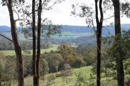
The King River is a major tributary of the Ovens River, and joins the Ovens close to the heart of Wangaratta (the confluence of the two rivers can be found by strolling through Merriwa Park, and then Kaluna Park). The King rises north of Mount Buller, west of Mount Speculation, and in its upper reaches offers a combination of waterfalls, mountain streams and rugged bushland. In its middle and lower reaches the King has created a very scenic valley, with great mountain scenery on both sides, and a perfect floodplain in the middle.
Explorers Hume and Hovell passed through what is now known as the King Valley in 1823. Hume named the Valley after another explorer, Phillip Parker King; Phillip was the only official son of the former New South Wales Governor, Phillip King, and explored much of Australia's northern coastline.
There is easy access to the Greta Valley from many parts of the North-east, however the route described here starts from the intersection of Tone Road (the old Hume Highway) and Greta Road, just near Coles Supermarket, Wangaratta.
With the tripmeter set at 0.00 at this intersection, the route heads south out of town, passing the Wangaratta airport, then crossing over the Hume Freeway via an overpass. You then need to take care at the Snow Road intersection, an off-set junction where you basically keep straight-ahead.
The bitumen now leads to a long run of pleasing farming country that continues all the way to Myrrhee.
Passing through the scattered settlement of Greta, the route now leads to Greta South, where you need to fork left at a y-junction, not far beyond the Greta South School, and about 35km from Wangaratta. This junction is not particularly well signposted, so it pays to slow down after having driven past the School.
Apart from the great scenery, landmarks in this section include the 15 Mile Creek Outdoor Camp (see www.boec.vic.edu.au for more details), Brookfield Farm (cafe, maze and accommodation - see www.brookfieldmaze.com.au for more details) and the gradual climb up to Myrrhee.
Just prior to entering the environs of this rural community, there is a side road (off to the right) that leads to the local recreation reserve, where there is plenty of room to stretch your legs, as well as a toilet block.
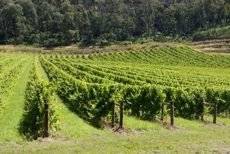
Coming into Myrrhee, there are many hectares of vineyards to drive past, as well as several wineries.
Passing by the Soldiers Memorial Hall (on your right) there is a signposted turn-off for Whitfield which leads to the Whitlfield - Tolmie - Mansfield Road. You can either take this turn off, or continue straight-ahead through the village itself, on to another signposted turn-off to the same roadway.
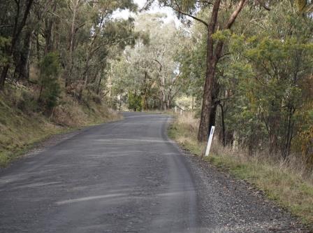
In either case, you will soon be on a gravel-earthen road that winds through some excellent forested areas, and joins up with the bitumen of the Whitfield - Tolmie - Mansfield Road on a sweeping bend. Take care here, as this is a downhill run for traffic coming in on your right, and vehicles can be moving quite fast.
Having merged in with the traffic, the roadway now makes a consistent descent to the western side of Whitfield, with some more great views on the way.
See the route description King Valley (link below) for a continuation from Whitfield.
See also . . .
BENALLA - TATONG - STRINGYBARK CREEK - GRETA WEST LOOP
MANSFIELD to the KING VALLEY (via Lake Nillahcootie, Tatong, Stringybark Creek and Powers Lookout)
ROSE RIVER VALLEY (Myrtleford, Lake Buffalo, King Valley)
Intro Screen on a fresh browser page
COPYRIGHT © 1995-2020, Chris McLaughlin.