BIKE PATHS, RAIL TRAILS and CYCLE ROUTES
(www.northeastvictoria.online)
BEECHWORTH RAIL TRAIL
[and Flame Trees Mountain Bike Trail]
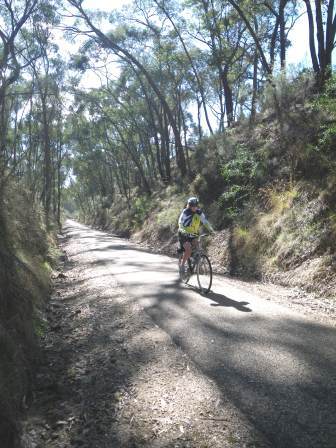
This Rail Trail runs from Everton Station (altitude 236m) to Beechworth (altitude 550m), following the path of the former railway that ran between the two towns. Everton to Beechworth is about 95% uphill, making the return journey a nice downhill run in cruise-control.
Distance covered is about 15km, and you should allow about 90 minutes for the journey (one-way, obviously the downhill run will be much faster than the uphill). The Trail is well suited to hybrid road bikes, as well as mountain bikes.
Most of the road crossings encountered are at road level; two have an overpass, but note that some maps of the area show the overpass locations incorrectly. Care is required at each of the unsegregated intersections.
There are several shuttle services operating out of Beechworth, Wangaratta and Myrtleford that will help position bikes for you, and/or come and get you from your chosen destination, and take you home. Your luggage can also be handled by the same companies.
As with any other cycle trip, weather watching should also be a part of your trip planning, with hot weather and wet weather being times to avoid. Dehydration will be a major problem on days of 30+, and wet weather creates miserable cycling conditions. The cooler months of the year often provide ideal cycling conditions, with a nice sunny day in autumn or winter being hard to beat.
Mobile coverage along the Trail is almost 100%, with Telstra currently providing the best outcome. Many riders take a small repair kit with them, including a spare inner tube, and the necessary tools to fix simple problems.
Don’t forget to take some nibbles in case you get peckish, and at least one litre of water per person.
Visitor Information Centres in the North-east have a brochure on the Rail Trail, and other cycling opportunities in the area, and this is well worth consulting prior to setting off.
Beechworth has a good array of shops and services, as well as a wide range of accommodation options, including motels, hotels and caravan parks (Lake Sambell and Silver Creek) and is a great place for a stop-over. See the Beechworth description (link below) for more details.
Setting off from Everton
Everton Station is a key stop-over on the Murray to Mountains Rail Trail; see the MTM description for details of how to get to Everton etc. Everton Station is about 2.5km from Everton township, so with a short detour, you can also access the Everton General Store, Everton Gardens Caravan Park and the Everton Hotel.
Setting off from Everton Station, take the Murray to Mountains Rail Trail east for about 400m, and then swing left onto the Beechworth Rail Trail. This leads into a section with a low gradient, with things getting steeper once you make contact with Diffey Road. Just after this brief contact, the first of several bridges are encountered. The Trail now leads past a pine plantation (on your right), and then a sustained climb, up to where the Trail makes contact with Diffey Road once more.
The Trail now parallels Diffey Road for several kilometres, crossing it once more before arriving at the former Baarmutha Station. There is a picnic table at the station site, as well as a typical railway station sign (saying Baarmutha of course) but no shade.
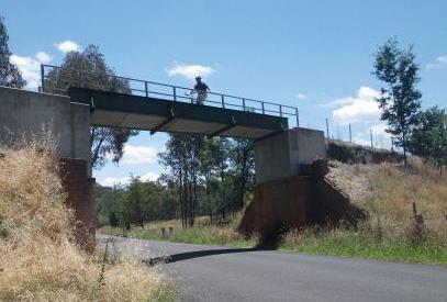
From Baarmutha, the gradient flattens out, giving a nice final run into the historic township of Beechworth. This involves crossing Diffey Road once more, followed by Fighting Gully Road (via an overpass), and then Bartsh Road.
Beechworth is now within easy reach, and the Trail makes a broad sweep to the north, getting ready to arrive in town via the appropriately named Railway Avenue.
The Rail Trail terminates at the former Beechworth Railway Station, and from here you need to swing left into Albert Road to get to the main commercial area of the township.
Setting off from Beechworth
This is an easy ride, being mostly downhill, with great views to briefly admire. As mentioned in the section header, there are several tour operators in the Beechworth - Myrtleford area that will organise a bike shuttle for you, so there is no need to tackle the uphill return to Beechworth if you don’t want to.
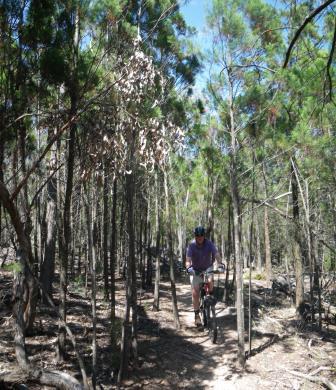
Flame Trees Trail (optional detour for mountain bikes only)
The Flame Trees Trail is a nicely graded mountain bike track that weaves in and out of the Rail Trail at various points, and makes a nice detour from the Rail Trail for mountain bike riders, or a mountain bike ride in its own right.
The start of this optional detour is at the Baarmutha Railway Platform, about one kilometre south of the first Diffey Road intersection (assuming that you are approaching from the Beechworth direction, this is about five kilometres from town).
At the downhill side of the Flame Trees Trail, you once again link up with the Beechworth Rail Trail, which then links in with the Murray to Mountains Rail Trail (MMRT) about 400m east of Everton Station.
Flame Trees is a single track route, and weaves to the south of the Rail Trail on its way west, tracking north of the Rail Trail on the return to Baarmutha.
An alternative link to the MMRT is to swing south onto Horseshoe Gap Road, and follow this (and the subsequent Cemetery Lane) to meet up with the Trail about five kilometres east of Everton. This is an unsealed route, but the surface is quite good enough for hybrids and mountain bikes. The views are excellent, and this is a mostly downhill ride.
If you want to drive directly to the start of the Flame Trees Trail, then you need to turn into Diffey Road (shown as Newey Road on some maps) from just on the western edge of Beechworth - this leads into Diffey Road, and then to the former Baarmutha Railway Station. There is a limited amount of car parking space at the ’Station’ and from here it is a short ride to the start of the Flame Trees Trail.
From the other (that is, downhill) end of the Trail, you need to take Diffey Road from Everton, this southern approach having the advantage of much roomier car parking.
See also THE DIRTY DOZEN website for more details.
MURRAY to MOUNTAINS RAIL TRAIL
WANGARATTA to BEECHWORTH LOOP (via Tarrawingee and Buckland Gap)
Intro Screen on a fresh browser page
COPYRIGHT © 1995-2020, Chris McLaughlin.