WANGARATTA - BEECHWORTH LOOP
(via TARRAWINGEE and BUCKLAND GAP)
(www.northeastvictoria.online)
TRAVELLING TIME: About 60 minutes (Wangaratta to Beechworth, and back down to the Great Alpine Road at Taylors Gap).
DISTANCE COVERED: 60km.
OVERVIEW MAPS: Touring map of Victoria.
DETAILED MAPS: None required.
SHOPS and SERVICES: Wangaratta has a full range of shops and services; Beechworth has a good array of shops and services.
ACCOMMODATION: Wangaratta has a wide range of accommodation options, including a nice riverside caravan park; see www.visitwangaratta.com.au for more details. Beechworth has a wide range of accommodation options, including motels, B&Bs, hotels and caravan parks (Lake Sambell and Silver Creek).
WHEN TO GO: Anytime.
ROADWAY DETAILS: Sealed road all the way.
OTHER INFO: Distances quoted may vary by several kilometres from one vehicle to another. See also the Beechworth town description.
This route starts by utilising a short stretch of The Great Alpine Road (GAR) which starts on the northern edge of the Wangaratta CBD, just north of the Ovens River Bridge. Alternatively, you can take the GAR exit from the Hume Freeway, about five kilometres east of Wangaratta; this is a full option interchange, so you can access the GAR from the north or southbound lanes.
Assuming that you start from the great city of Wangaratta; on the way out of town the Road passes through a small remnant section of red gum, floodplain forest, and the Hume Freeway interchange is encountered about five kilometres out of Wangaratta.
This is quickly followed by the Firefighters Monument (on the right, near the Petticoat Lane intersection); the monument commemorates the service and sacrifice of ten volunteer firefighters who lost their lives in this area during the 1943 Bushfires.
This was one of several events that lead to the creation of the present day firefighting service, the Country Fire Authority (CFA) in 1945. There is very little dedicated parking near here, so take care with passing traffic.
From the Monument It is then a further five kilometres to the small scattered settlement of Tarrawingee, and the turn-off to Beechworth and Yackandandah (the C315). Swinging left onto the C315, just around the corner, the Plough Inn (National Trust classified) serves an excellent meal, but not every day of the week. An anecdote from history has it that Ned Kelly used to ride his horse into the main bar of the Plough Inn.
Adjoining the Hotel, Ladsons Store (also known as Carinya) is a two-storey brick building built in 1860 by Thomas Ladson. Ladson ran the store until 1880, and then sold the property to Hopton Nolan. Nolan passed the store on to his son Thomas, and since then the property has been home to four generations of Nolans. The buildings were classified by the National Trust in 1984, and in 1986, after a long period of neglect, the Nolan family decided to restore the landmark building to its original glory.
Leaving Tarrawingee behind, the 24km route to Beechworth now heads for some rolling hill country, and not far out of Tarrawingee, there is a sign-posted turn-off to Tolpuddle Dairy, specialists in goat cheese products.
The floodplain of the Ovens River is soon left behind, and it is a steady climb up towards the historic township of Beechworth, with sandy soils and granite outcrops becoming evident as the township is approached.
Dropping down a small valley, Golden Ball Bridge provides dry passage over Hodgsons Creek, and was the site of a hotel (The Golden Ball Hotel) in the Kelly Era; rumour has it that this was where Aaron Sherritt told tales to the constabulary about the Kelly Gang.
Indigo Winery is just before Golden Ball Bridge (to the right), and is open for wine tasting most days of the week, with food being served on weekends and holiday periods. More details at www.indigovineyard.com.au.
GlenBosch Estate Winery is on the left, just beyond Indigo Winery; more details at www.glenbosch.com.au.
Continuing towards Beechworth, the geographical feature known as Flat Rock is to the left, and provides a nice vantage point of the rugged terrain northwards Eldorado and Mount Barambogie.
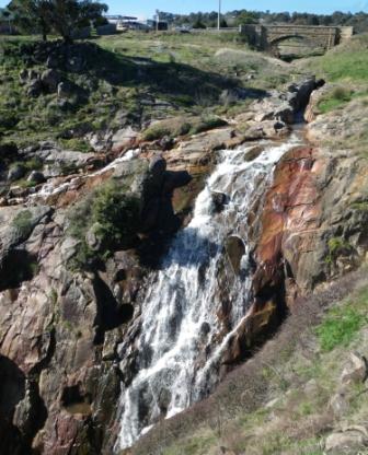
Continuing on the C315, the famous Black Springs B&B is a short distance down the bitumen (on the left), and the town centre is now only a few minutes away. This final run involves crossing Newtown Bridge, a stone (mostly granite) structure over Spring Creek that was completed by Scottish stone masons in 1875. The new bridge replaced a wooden bridge which was slightly upstream of the present structure. A large water-powered mill once stood at the head of the falls (just downstream of the bridge), supplying the town with locally ground wheat.
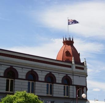
Just beyond this structure there is a memorial obelisk that commemorates the discovery of gold in this area in 1852, with the roadway swinging to the left of this structure for the final run to the town centre via Ford Street. See the Beechworth description for things to see and do in this great town.
Return to the Great Alpine Road
Heading back towards the GAR involves taking Camp Street/Albert Street from the centre of town, and then swinging right onto Kerferd Road (the C524, signposted Myrtleford, a route also known as the Buckland Gap Road).
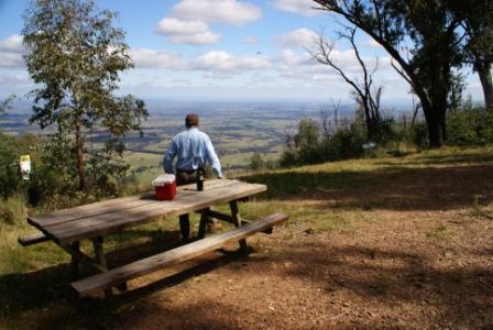
After leaving the environs of Beechworth, the C524 completes a brief climb to Buckland Gap, and then begins its alpine style descent back to the valley floor. The most notable aspect of the descent is the views over the Ovens River floodplain; these are quite spectacular, particularly on a hot day when there is a noticeable heat haze.
At the Gap there is an information board on the left telling the story of the Royal Oak Hotel, a well known watering hole that stood here from about 1858 to 1958.
Prior to the descent, there is a signposted left turn to Murmungee Lookout where more great views await you. This is a gravel run of about two kilometres, with the gravel usually being quite well graded.
Near the end of the descent (on the left, in the midst of the scattered settlement of Murmungee) there is a memorial to the explorers Hume and Hovell, one of many such memorials in North-east Victoria that commemorate the importance of this 1824 epic.
The C524 meets up with the GAR about 15km from Beechworth, about 22km from Tarrawingee, and just west of Taylors Gap. Turning left here puts you on track to continue towards the high country on the GAR, whereas turning right leads back to Everton, Tarrawingee and Wangaratta.
At this point Myrtleford is about 11km away (to the left); Bright is 42km away (also to the left); whilst Wangaratta is about 34km to the right.
BEECHWORTH (via ELDORADO and WOOLSHED VALLEY)
Beechworth Historic Park website
Beechworth Visitor Information Centre
Intro Screen on a fresh browser page
COPYRIGHT © 1995-2020, Chris McLaughlin.